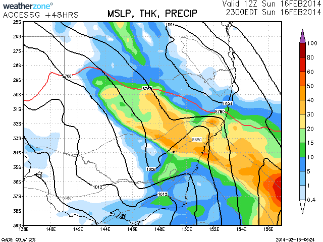
Rain is finally falling from this long awaited and much needed rainfall event. There are pockets amongst this rain band of moderate to heavy rainfall and it seems models predict more substantial falls by late Sydney evening. Falls of 50mm are not out of the question. in some suburbs given the model predictions. It seems other areas in NSW may even receive heavier rainfall with falls between 50 to 100mm overall and some of these heavier patchy falls may be in regions affected by severe drought.
The drought situation across NSW is critical with some farmers down to their final stock feed. Price of feed has increased dramatically due to demand. There are hints rain may also occur in southwest Queensland from rainfall events in the near future.
Dam Capacity in the Sydney catchments Warragamba Dam is sitting at 84.5% as of 11th February so there is no shortage of domestic water for Sydney from the previous year's consistent rainfall that filled capacity to near 100% on two occasions. The rise in the dam wall construction project by 5 metres completed in 2002 would have added a substantial amount of storage capacity. And of course there are plans to raise the level by 23 metres in the next project if it goes ahead.
Intermittent rain here at the moment but at least persisting. Interesting to see how this low develops and interacts with the moisture indeed as it nears better access to moisture!
Further to the above post, the rain across Sydney is consistent but as at 12 noon 15/2/2014, the falls have been light across the city.
Up until 9 am Saturday morning, falls around Sydney have been very light anywhere from ‘Nil” in a few suburbs up to 5.5 mm. Only 2.5 mm around where I live and 2.4 mm at nearby Prospect. A brief moderate shower around 9 am has boosted the figure around Blacktown by a further 0.5 mm for the period 9 am to 12 noon.
Interestingly Richmond and Windsor in Sydney’s NW have had 8 mm each during the 3 hour period 9 am to 12 noon.
Overnight some big totals in far south west NSW including 60 mm at Karpa Kora (A farm or cattle station NE of Pooncarie), 95 mm at Pooncarie, 78 mm at Burtundy Station (Cattle farm or station), 78 mm at Willow Point, 68 mm at Benilkie and 62 mm at Balranald. This area is relatively isolated from any big town but generally south west of Broken Hill or NE of Mildura.
In adjacent north west Victoria, 68 mm fell at Werrimill and 56 mm fell at Annuello. The rain passed over Mildura but unfortunately it appears that the rain guage was not working and hence a figure was not available when I last looked.
Further east the rainfalls lessen in intensity and amount but Hay collected 34 mm. Southern NSW around Albury and environs collected 22 to 23 mm from light steady rain or drizzle and Cabramurra collected 25 mm till 9 am. Elsewhere falls were lighter or non existent especially towards the NE of the state.
This system still has time to deliver more rain in areas where it is needed most and the BOM models do show 25 to 50 mm across a wide swath of the state especially across the east as the weekend progresses.
Harley, you are correct, it seems that rain has been light today a few moderate patches this morning. Let's sees what happens tomorrow. There is an upper trough coming through and it may trigger some activity.
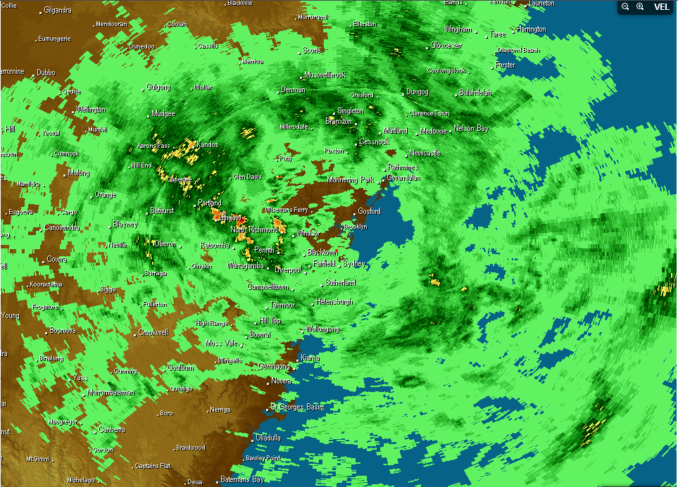
There's a stationary convergence zone on the northern outskirts of Sydney today visible on the radar. The winds are northerly on the central coast and southerly in the Sydney basin and westerly on the mountains. With an upper trough coming through i think we could see a low pressure spin up on the coast around broken bay this afternoon? Heres hoping as we could use a good few hours of heavy rain.
As requested, I have complied some rainfall totals for the 24 hour period to 9 am 16/2/2014.
Generally, light patchy showers and light rain has been a feature for Sydney and while it has been persistent, the rainfall totals have been minimal to light with only isolated totals reaching 10 mm or more.
During this period, Narrabean recorded 14 mm (The highest) followed by 12 mm at Mona Vale. Richmond had 11 mm and nearby Windsor had 10 mm. There were no other totals exceeding 10 mm. The rest of Sydney had 2 mm to 9 mm but 3 mm to 4 mm across the southern half of Sydney was common. There was 5 mm at Blacktown where I live.
There have been slightly more moderate falls between 9 am and 12 noon but the falls range from 1 mm to 4.6 mm including 3 mm at Blacktown. The falls are widespread but lacking significant intensity.
There have been some better falls elsewhere but the higher totals are isolated in nature rather than extensive.
Canberra city and environs had 16 to 31 mm but much lower totals outside the region especially to the north and east. A small area centred on the Brindabella Ranges and Snowy Mountains had big totals including Mt Ginnini – 57 mm, Corin Dam – 52 mm and Cabramurra – 39 mm. Batlow had 64 mm (Probably local topography influencing what was going on). Finally Burrinjuck Dam (Yass region) had 39 mm.
Another area that received anything of significance were isolated farming properties or small communities along the Darling River or Western NSW such at Waterbag Station – 29 mm, Tilpa 51 mm and Cobar 63 mm.
The only other area to receive anything of significance was a small area around Orange being 28 to 42 mm including a total of 35 mm at Mandurama.
A pattern is emerging from this event in which there are some reasonable rainfall totals but the totals are localised or isolated and hit and miss. The rain is widespread but many areas are missing out on the good totals. The relief from the dry is patchy and of course, the northern inland of New South Wales has had nothing to date.
The southerly change has gone through Sydney and there are further showers but there is the promise of some good rainfall totals north of Sydney. Further, I am aware of some heavy shower activity, possibly thundery on the southern Tablelands not too far from Braidwood that should boost rainfall totals in that area.
The southerly just hit here and it brought strong gusty wind and sheets of heavy rain for about ten minutes