Following the recent landfall of Tropical Cyclone Megan over the southwest corner of the Gulf of Carpentaria, moisture spread southwest deep into the interior of the Northern Territory and Queensland.

As a result, steady rainfall between Thursday 21 March and Tuesday 26 March featured across a vast desert region. The rain was long lived and steady rather than torrential in nature. Cumulative weekly rainfall totals topped 160 to 240 mm around Alice Springs which was more than enough to generate flooding along the usually dry Todd River.

The figures as shown on the attached weekly rainfall plot for the Alice Springs region approach the average yearly rainfall for the town.

Heavy rainfall drenches inland Australia turning the red centre to the green centre March 21 to March 26 2024.
Cumulative 7 day rainfall plot for the Alice Springs region to 9 am Friday 29 March 2024. As shown, rainfall from the event topped 180 mm up to 243 mm around Alice Springs which is approaching the towns average yearly rainfall. The result was flooding along the usually dry Todd River.

So far this year, 278.6 mm of rain has fallen at Alice Springs to 9 am Friday morning 29 March 2024. The average yearly rainfall for Alice Springs is 283.1 mm (Source Weatherzone). As such, another 4.5 mm of rainfall would be needed for the average yearly rainfall to be reached which is incredible for a town located within the heart of Australia.


The best way to see the red centre of Australia is from an aircraft and as shown in the photos, the affected regions is generally desert with little or no vegetation cover. The photos of the affected region are taken from around 12,000 metres flying over Australia in 2016.

Heavy rainfall drenches inland Australia turning the red centre to the green centre March 21 to March 26 2024.
The best way to see the inland is to see it from the air flying over the region in an aircraft. Images of what the region usually looks like being desert and salt pans taken during 2016 when flying across the region. It was this region across the Northern Territory that received the heavy rainfall.
Heavy rainfall drenches inland Australia turning the red centre to the green centre March 21 to March 26 2024.
Southern Northern Territory is truly the red centre. This is what the region looks like. Photo taken in 2016 from 12,000 metres whilst traveling over southern Northern Territory. This area has received upwards of 200 mm of rainfall from the event.


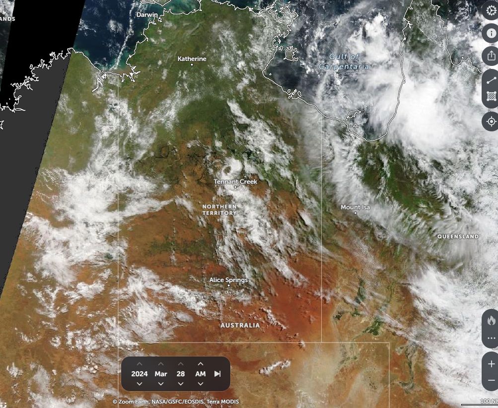
Extensive and thick cloud over the past few days has resulted in a remarkable transformation of the red centre. The latest satellite photos of the affected region shows greening occurring and even a transformation to a “Green centre” across some regions.

Heavy rainfall drenches inland Australia turning the red centre to the green centre March 21 to March 26 2024.
Zoom Earth (NASA) March 23 2024 - Thick cloud over the region provides steady long lasting rainfall across the Northern Territory.
Heavy rainfall drenches inland Australia turning the red centre to the green centre March 21 to March 26 2024.
Zoom Earth (NASA) - A greater view of the extensive cloud mass stretching from inland Queensland to Northern Western Australia during March 23 2024.


Floodwaters are visible near Tennant Creek (Northern Territory).

Heavy rainfall drenches inland Australia turning the red centre to the green centre March 21 to March 26 2024.
Zoom Earth (NASA) - Tennant Creek is generally another dry area with much of the region desert like country. However, this event has transformer the area. As shown, thunderstorms lie to the north of town and floodwaters can be seen north west of the town. Image - March 26 2024.
Heavy rainfall drenches inland Australia turning the red centre to the green centre March 21 to March 26 2024.
Cumulative rainfall for inland and eastern Queensland to 9 am Friday 29 March 2024. As shown, there are large regions where cumulative rainfall topped 100 mm to 200 from the event.


There are even pockets across northeast South Australia which are amongst Australia’s driest regions that are showing signs of turning green.

This shows how much rain has fallen from the ex-tropical cyclone.

Heavy rainfall drenches inland Australia turning the red centre to the green centre March 21 to March 26 2024.
Cumulative weekly rainfall for South East Queensland including Brisbane and Sunshine Coast for the week ending Friday 29 March 2024. As shown cumulative rainfall totals easily exceeded 100 mm for much of Brisbane and the wider region during this event.

The cloud tracked south then southeast across Queensland which brought a long lived period of steady rain across much of inland Queensland before passing out to sea across southern and eastern areas of the state.

This is likely to be the last major rain event for the season for the affected regions but it was also a major event which has had a dramatic impact across vast swathes of the inland.

Various satellite photos are attached showing the cloud mass that brought the rainfall. Included are the cumulative weekly rainfall plots for some of the affected regions for the week ending Friday 29 March 2024.

s2Member®