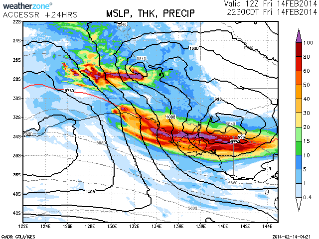
 South Australia southern and south east region is expected to receive substantial falls of rain today and hopefully this will be sufficient to put out any bush fires! South Australia has been experiencing drought and some record heat wave conditions with temperatures into the 40C and above on many days this summer including Adelaide. More than 70mm of rain and flooding due to blocked drains have occurred in Adelaide causing chaos on the roads with their heaviest rain in 40 years! More rain is predicted today as the system winds across the state!
Rainfall totals would be mostly in the 50mm range but falls of up to 100mm are possible if the models hold correct. The system which was in north western Australia creating moderate to major flooding has begun to break down and the associated cloud band will spin off into the southern parts of South Australia in spectacular fashion! Significant rainfall should also be experienced in the deserts across the north of the state from another region of activity.
The associated low pressure system and trough with cloud band should exist the region and move into NSW today and over the weekend providing much relief from one of the worst droughts on record!
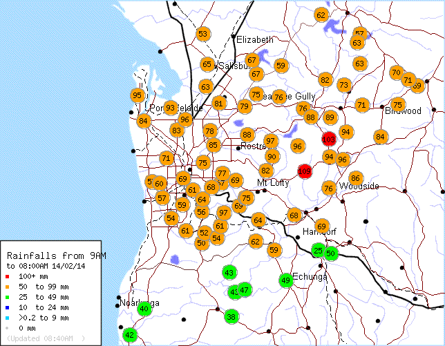
Impressive totals for Adelaide – up to 100mm in the hills!
Impressive totals for Adelaide – up to 100mm in the hills!
Impressive totals for Adelaide – up to 100mm in the hills!
Placed a rainfall map of the totals on this article!
Placed a rainfall map of the totals on this article!
Placed a rainfall map of the totals on this article!
The final rainfall totals for Adelaide is impressive considering the city has sweltered through a summer that had delivered a staggering 13 days where the maximum temperature has reached 40C including 10 such days where the maximum temperature has reached 42C.
This rain event is quite amazing for a city that has experienced such a hot dry summer to date and demonstrates two significant weather events for the summer period. The rainfall event is relatively localised to Adelaide. Rainfall totals are much lighter further east and south although some worthwhile falls are starting to occur around Whyalla further north.
The rain has continued throughout Adelaide after 9 am but so far falls are nowhere near as heavy. This will give the city a reprieve from the oppressive heat endured this summer.
Of interest, the rainfall plot in the earlier post shows the heaviest fall as being 109 mm to 8 am. By 9 am the final total for the 24 hour period for the heaviest fall was 110 mm at the same location.
The small town of Snowtown north of Adelaide has had a major rain event during the afternoon worth considering given its location. The rain guage shows a deluge durng the afternoon of the 14 February as follows:-
11 am – 2 mm.
11.30 am – 3.4 mm.
12 noon – 3.8 mm.
12.30 pm – 4 mm.
1 pm – 6 mm.
1.30 pm – 7.4 mm.
2 pm – 15.6 mm.
2.30 pm – 25.6 mm.
3 pm – 35.8 mm.
3.30 pm 53.2 mm.
4 pm – 70.6 mm.
4.30 pm – 78.6 mm.
5 pm – 80 mm (The rain clears with the finally tally at 80 mm).
Much of this falls in 2.5 hours between 2 pm and 4.30 pm being 63 mm for that period. This is an isolated fall for the region.
That is quite significant for Snowtown and Adelaide to have such rainfall totals. Some are mentioning since the 1960's.
That is quite significant for Snowtown and Adelaide to have such rainfall totals. Some are mentioning since the 1960's.
That is quite significant for Snowtown and Adelaide to have such rainfall totals. Some are mentioning since the 1960's.