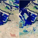

Major storm and flooding impact the United Arab Emirates – April 16 2024
The United Arab Emirates is not usually associated with storm events and flooding episodes due to its climate and location. The area generally experiences a desert like climate with limited…
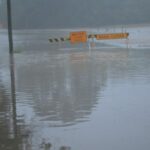
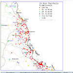
Major rain and flood event for Sydney and Wollongong – 5 and 6 April 2024
As indicated within a previous post, a significant rain event was anticipated to unfold across Friday and Saturday 5 and 6 April 2024. At that time, weather models anticipated an…
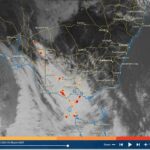
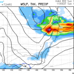
Potential for a significant rain event for coastal New South Wales – Thursday to Saturday 4 to 7 April 2024
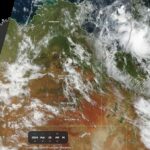
The final burst of summer for 2023/2024 will conclude during Monday and Tuesday due to the passage of a significant weather change. As shown in the Himawari satellite photo of…