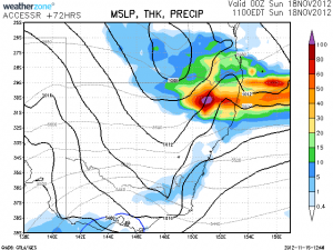
 There is the potential for some decent rainfall totals over northern NSW as a system winds up in the region particularly overnight Saturday into Sunday. This has been on the cards for some days. Interestingly, the usually excited GFS model was in disagreement this morning on the positioning of this event moving into SE Qld. Storms are possible immediately behind the rain region.
Some storms if the right conditions occur could become quite severe with very large hail and strong winds. Some are even talking the possibility of tornadoes given the low level wind shear environment.
There is a little concern in terms of the mid-level cloud and now the SE change that is expected into Brisbane.
What are people's thoughts for Saturday? Last I checked the Bureau model and GFS had different locations for this to occur!
I wasn't thinking much of a rain system. More of an afternoon storm system? Seems pretty dry in the upper around the afternoon until development kicks in?
Yes I know there could be storms and some severe storms. I am not as fond on the mid-level cloud though the mid-levels 500hPa up are generally fine. I heard of a forecast mentioning isolated tornadoes – what are people's thoughts?
Well the LLJ is looking particularly potent! pushing 35-40knts last time I saw at 925 from the NE. Western downs is the locality of this.
Looking at the current 18z set up and it looks like there is very good potential to see some severe storms tomorrow. Low level winds look quite dynamic and deep moisture should allow for lower bases so I would not rule out the possibility of anything tomorrow. I am favoring the Northern Tablelands from Guyra north and I'm sorely tempted to chase.
Headed up there for tomorrow's action but not as happy with the mid-level cloud. I guess we will see.
Well we just through Guyra just before 2am. I don't know how to explain this but was this a case of indecent exposure or is this schoolies week Guyra style? These chicks flashed themselves at us – the things that can happen in storm chase trips – this takes the cake!
Hi, we may have not been able to catch the high based major cell near Toowoomba but we had a nice developing cell near Stanthorpe but the anvil from cells to the west cut out the heating. The cells near Inverell were too far. However, out of the dull moments, Colin got swooped by an owl- it only went when he threatened to punch it.
I hope your onto some nice storms Jimmy! Looks like a potential super cell in the Darling Downs and a nice right and left spliting cell near Inverell earlier.
Hi, we may have not been able to catch the high based major cell near Toowoomba but we did had a nice developing cell near Stanthorpe but the anvil from cells to the west cut out the heating. The cells near Inverell were too far. However, out of the dull moments, Colin got swooped by an owl- it only went when he threatened to punch it.
I was watching that cell near Toowoomba. It seemed to move NE and passed just to the west of the city. It seemed to be a large storm and the core went red on the radar. It appears that a smaller storm cell developed in front of it north of Toowoomba.
Wow, some impressive storms in SE Qld tonight. This cell which is the southern most warned storm over the Lockyer Valley is showing a very interesting doppler return and it appears that rotation is intensifying in this cell!
Was there a supercell somewhere between Evans Head and Lismore not long ago? I would 2 loved 2 have checked the radar just a bit earlier.
Cell now has a specific dangerous storm warning!
Seems we are not the only ones who question late warnings from the BoM
Murray John, there was a nasty black core tracking Woodburn to Ballina a while ago. Trees down near Woodburn and a number of calls to the SES for help I have heard.
Congratulations on those who got onto the beast – Michael Thompson, Jeff Higgins, Andy…et al. Great stuff. It was a very powerful supercell. It obviously took on a nice shelf cloud appearance when it hit the moisture! Can't wait to see more pictures and video.
Take a look at the visible satellite image for this storm near Toowoomba.
Nice satellite image for this event! I posted it on http://www.extremestorms.com.au.
I read on Weatherzone that hail up to 8 to 10 cm was recorded just north of Pittsworth. Pittsworth is SW of Toowoomba on the Gore Highway. It would have come from that intense storm cell that moved NE. Seems like the big hail fell across a rural area. The Weatherzone report did not mention damage reports from that event.
Looking at rainfall from the event, the Lockyer Valley stands out. Gatton – 96 mm but nearby Lake Clarendon Alert 114 mm and much of Brisbane especially north of the river received 60 to 90 mm. Much of the rain from the storms was concentrated in that Lockyer Valley region towards Brisbane.
Teamed up with MB yesterday and proceeded with a 900km return chase to the Darling Downs. We managed to get onto the storms from initiation and watch some of the most amazing structure and lightning I have ever witnessed in Australia. The way the cells rapidly intensified into mesos was incredible, US like in some ways. Here are two of my favs from the chase
Wall cloud with RFD behind starting to throw out giant hail near Pittsworth.
One of the thousands of intense CG strikes in front of the storm near Oakey.
James
what happened near woodburn last night? does any have any info as it sounds like the cell in NSW that moved north through that area has produced etheir a severe microburst or a tornado. there is a report of localised severe structural damage to houses there.
I chased yesterday with James Harris and also met up with Matt Smith and Shane Watson. We were onto the beast supercell from the first cumulus cloud near Milmerran and 5 hours later to north of Oakey. It was epic. The inflow was strong almost all the time – just some brief outflow which was overcome quickly. The lightning out the front of the storm was insane and dangerous and started some fires. A real US-type chase, with 900km on the clock by the time we got home. These are in sequence. We got some hail from the first cell, with the main supercell then forming just to its north. We avoided letting the huge hail get us – plus the structure was so impressive – gotta love the weather.
MB
Wow, those photos are epic Michael!
That lowering in the third shot Michael, what is that? Is that inflow or a really intense hail packed outflow? That looks phenominal and very dangerous at that point! Also i love the beaver tail in the last couple, what amazing storm structure!
Here’s the radar for the supercell that tracked north east towards Ballina and caused the significant damage at woodburn.
See : 128km Radar Loop for Grafton, 04:00 17/11/2012 to 12:00 17/11/2012 UTC
Looking at the cell when it was over Woodburn, Just next to Evans Head and I wonder if the damage wasn’t actually caused by a tornado. There appears to be a notch in this cell and the worst outflow occurs further north near Ballina itself. Maybe worth a look MB?
Hail core Jeff. Around the time of the second photo was when it looked possible to produce a tornado structure-wise. Then it was all HP.
Been too busy with work to go through more pics or check video. I don’t have any other info about the Woodburn damage – Halden Boyd posted some lightning pics at the time of it, but doesn’t show what might have been going on.
Great photos Michael. Great to see so many people out there. Here is one photo I took on Saturday. Such an amazing storm!
Some more amazing pictures added by Michael Bath and Michael Thomas! Wow!
Hi Jeff Brislane, we, Colin Bryant and I did a brief damage survey enroute Sydney. I doubt there was a tornado in this. isolated houses sustained damage and often weaker structures. We will post images online when we get a chance. Still recovering from a major drive and early 3:15am arrival. Then I went to work!
Hi Michael Bath, I guess I was not there to be able to comment. However, the second image shows a worrying sign in terms of any chances of tornadoes. A dense core of rain and hail is dropping from the storm at the back. We saw something similar to this in 2004 near Nyngan. The storm became outflow dominant after that stage. It is critical that cooler air does not work its way under any developing surfaced based mesocyclones. It seems either the storm was not moving rapidly or the upper level support was just not enough to get things going. I mean the strong inflow seems to have been there!
Hi Jimmy,
Shortly before taking the photo which I posted, the storm did produce several lowerings which made it approx. half way down to the ground. I would not confidently call these funnels but they did have a cylindrical/cone shape. They were not very long lived but did look very convincing. Unfortunately, I do not have photos at that stage as we were driving. Really hard work navigating, trying to avoid rain, get in position etc! The lightning was also very unnerving.
I assume others probably saw these lowerings as well?
Yep certainly saw a few of those Michael. I got one of them on video and Im pretty sure MB got a heap as well. Will try and get some time to put those videos online soon.
Jimmy your spot on re the outflow from the RFD causing havoc. There were a number of times where it was getting very organised and looking likely something may happen but then the outflow would kick it out just a little ruining any chance. The storm wasnt moving rapidly especially at the start however got going a little later. Maybe it wasnt support upstairs?
I had the kestrel out and was recording average wind speed of around 35km/h with gusts to 45km/h in the first and second photos increasing to 40km/h average and 50km/h gusts in the third photo. That was about the strongest it got before dropping back down in the latter photos.
Great to hear James, look forward to seeing the footage.
Regarding the RFD, I think the two photos below illustrate this nicely. Note in the second photo the scud forming from the RFD pushing out and the precipitation starting to fall into (what was) the inflow notch. When the storm started moving to the NNE, in theory the SRH should have increased.
Hi James Harris, you also got some excellent images! I look forward to seeing the funnels. Was the rotation very rapid guys?
Okay, I obviously don’t know how to post here properly.
Here is what was meant to be the first photo-
Under the anvil shield, a low contrast LP appears behind the rain of the monster! The stage Colin has was a little more clearer. It then went into rapid decline from there.
I mean what else could go wrong on this particular chase – this is Jimmy arriving home from the recent storm chase!
In seriousness, this was an opportunity to inspect the damage from the Woodburn event.
and…
and this one..
..and finally the sign. The damage here seems more consistent with microbursts. It was widespread and hit and miss with weaker structured or poorly designed homes.
Awesome work chasing those cracking storms everyone