
The city of Fort Mc Murray lies approximately 56.43 degrees north and 111.22 degrees west in north east Alberta (Canada). Some 80,000 residents live within the municipal region.
The climate features severe cold winters with snow and summers are short due to latitude although it can reach 30C during the short summer season. The highest temperature recorded is 37C on 10 August 1991 while the lowest is minus 50.6C on 1 February 1947.
Rainfall is relatively low at 464.8 mm per year and snow cover is assured during the long cold winter. The bioclimate is generally boreal moist forest which provides some background to the climate of the region.
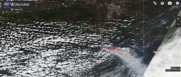
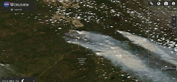
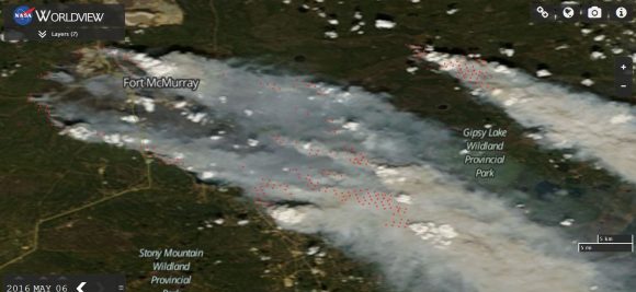
A wildfire within this region is highly unusual which has caused the evacuation of over 80,000 residents. As seen from NASA'S Terra MODIS satellite, vast plumes of thick smoke casts a shadow across over the region. It appears the worst of the fires is to the east and south east of the urban areas and fires have been fanned by dry southerly winds.
Using the NASA's Worldview system, the fire hot spots have been overlaid across the image to provide a better image of the hot spots.
There is also a separate fire burning north of the Gipsy Lake Wildland Provincial Park. At the time the satellite passed over, a cold front had passed through and winds were north west which would help fire fighters. Conditions are now cooler than that of recent days.
Recent maximum daily temperatures that have occurred are:-
1 May 25C.
2 May 27C.
3 May 33C (This was the day when the fires took hold as seen in media reports).
4 May 32C.
5 May 19C.
6 May 20 (To date).
A forecast top temperature of 27C is being made for May 7 with cooler conditions to come thereafter.
Recent overnight minimum temperatures for the same period are:-
1 May 1C.
2 May 4C.
3 May 11C (The nigh time conditions have been cold).
4 May 10C.
5 May 12C.
6 May 8C.
It can be seen that the minimum temperatures have been somewhat cold during this period which makes this event incredible.
When reviewing rainfall data for February to May, it can be seen that it has been dry. The heaviest rainfall has been 11 mm recorded on April 13 2016. The forest has dried out over recent months and given the right conditions, a fire has taken hold and reached such catastrophic levels.
It appears the worst of the conditions are over as long range forecasts do point to colder conditions and some rainfall which will help to ease the fire situation and assist fire fighters in containing the blazes across the region.
CREDITS
1 - Accuweather - Weather data for Fort Mc Murray for 1 to 6 May 2016.
2 - Fort Mc Murray Alberta Canada Climate data.
3 - NASA (Worldview) TERRA MODIS using fire and hotspot overlays acquired 6/5/2016.