A remarkable sequence of weather events has recently unfolded across South - Eastern Australia from strong early October heat to a significant rain event that resulted in flooding for some locations.
Tuesday 3 October 2023
During Tuesday, a second burst of heat resulted in maximum temperatures across Sydney reaching the mid to high 30s for the second time this month. Maximum daytime temperatures across Sydney again reached between 35C and 37C as follows:
- Sydney Airport - 37.2C.
- Badgerys Creek - 36.8C.
- Richmond - 36.8C.
- Penrith - 36.5C.
- Horsley Park - 35.8C.
- Observatory Hill - 35.7C.
This is remarkable as this is the third time this September and October that daytime temperatures have surpassed 35C across much of Western Sydney.
High daytime temperatures were also recorded across North West New South Wales including 36.7C at Bourke.
The start of October 2023 has been hot for Bourke and surrounding regions including 38.5C on the 1st then 39C on the 2nd then dropping slightly to 36.7C on the third. Cooler weather during the 4th ended the run of hot days.
During Tuesday, the developing cloud mass and its size limited the area impacted by the heat to eastern, northern and the upper north western areas of the state.
In addition, there have been worsening bush fires or grass fires affecting regions such as what occurred at Bermagui (New South Wales Far South Coast) and areas near Bairnsdale in Victoria.
Areas to the west and south west of the state under the influence of the cloud mass and rain were nowhere near as warm.
As such, a significant temperature contrast existed during Tuesday ranging from what occurred across Sydney (Mid 30s) to barely 20C along the southern state border areas of Victoria being the areas underneath the cloud.

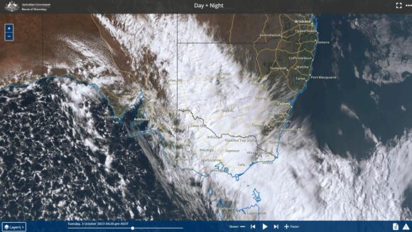
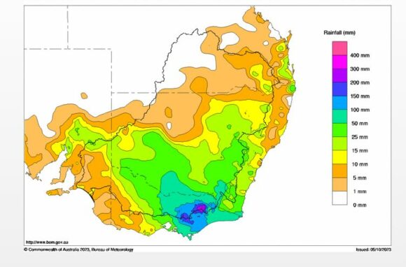
A developing cloud mass and strong cold front brought some significant rainfall and even thunderstorms to parts of inland New South Wales during Tuesday then into Wednesday. The cloud and rainfall trained over the same area for up to 24 hours before shifting further east and south. As such, some areas received significant rainfalls including:
- Balranald - 60.2 mm during Tuesday.
- Hay - 49.8 mm during Tuesday.
- Albury Airport combined rainfall through Tuesday and Wednesday as the event crossed through 2 recording periods - 61 mm.
Across Eastern and North Eastern Victoria significant rainfall doused fires, eased developing dry conditions and replenished dams and river systems. Total combined rainfalls topped 200 mm at isolated locations including:
- Mt Hotham - 254.2 mm.
- Falls Creek - 202 mm - (Up to 210 mm has fallen this month at Falls Creek).
- Mt Hotham Airport - 147 mm.
- Mt Moornapa - 143.8 mm.
- Mt Buller - 143 mm.
- Latrobe Valley - 127.4 mm.
- Lake Eildon - 121.2 mm.
- Benalla - 95.6 mm.
- Omeo - 91.2 mm.
- Bairnsdale - 90.4 mm.
- Dartmouth - 78 mm.


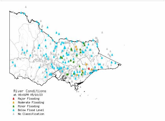
The heaviest falls occurred within the ranges and as a result, minor to moderate flooding has occurred as shown in the river conditions plot of Victoria derived on Thursday 5 October. Flooding occurred along the Ovens River at Wangaratta in North - East Victoria and along smaller rivers of South East Victoria.
Wednesday 4 October 2023
By late Wednesday, rainfall set in across Sydney after 5 pm but most of it had cleared by 10 pm. Rainfall totals ranged from 8 mm to 15 mm with the heavier falls across Sydney’s West. While not a significant event for the city, it did end the run of warm and hot weather for a while.
Attached to the post are:
- The cumulative 2 day rainfall plot for the Murray Darling Basin showing clearly where the heavier falls fell.
- The Himawari Satellite picture of Southern Australia showing the developing cloud mass across Southern Australia late Tuesday.
- The River Conditions plot for Victoria showing the rivers in flood following the rain event.
Despite the declaration of an El Nino event, this event has been significant especially for the areas that benefited the most. It has eased developing dry conditions and should allow farmers to finish their crops for the year. However, while this is said, it must be remembered that large areas of the state across the north did not receive such high totals and thus dry conditions are still prevalent and continue to worsen.
