
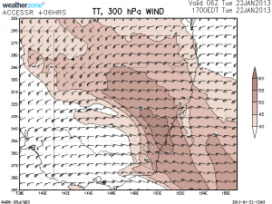
 Hi Everyone, I know this is a little early and i know that Tuesday and Wednesday should see storms fire up again along the NSW east coast, but i'm really excited by what the GFS model is throwing up for Friday and Saturday. So much so that i've started this thread about the potential. I plotted Fridays 06z run this evening using the last 00z data and the setup for the far Southern Tablelands and South Coast is looking very promising! Strong turning winds increasing in speed aloft, a fairly strong cap around 20c, good LI and a potential triple point setting up by 06z and a very sharp upper trough approaching rapidly. The only thing out is the CAPE but with the other factors so favourable i don't think CAPE will be a problem.
Saturday is also looking promising with a second upper trough coming through and favorable instability but less favorable shear. What do others think? Could we have a setup capable of producing multiple supercells or even an isolated tornado?
Regards Jeff.
I have seen potential for storms as well. I am taking a flexi day Tuesday and will have a look at what happens around the Southern Tablelands around the Bowral area. Looking at the models for Tuesday, it appears that coastal areas including Sydney, Blue Mountains and the Southern Tablelands have opportunities for storms but it would not be advisable to go much further inland.
There is a southerly change moving north along the coast during the afternoon and this is one reason why I am heading towards that area. The BOM Access model show dew points around 16C to 17C range when looking at 5.40 am this morning and surface temperatures around 30C in that region early afternoon. I have looked at the temperatures at 500 level for the afternoon and the models suggest a region of minus 10C across that region as well as Sydney.
Chance of storms are forecast for places such as Bowral, even Goulburn, Canberra, Bathurst and Lithgow. For Sydney, the forecast appears to suggest greater chance for storms in Sydneys west.
Hopefully there will be activity in that area and this would represent the first set of storms for 2013 that I can enjoy.
But what do you think about this Friday and Saturday Harley? I putting it out there by mentioning the chance of an isolated tornado. I'll see what the 12z run is now suggesting but I hope it stays firm.
Today, I had another good storm chase and for the first time, I used three cameras. I targetted the Mittagong / Bowral / Berrima area as suggested in my earlier post.
Small thunderstorms began to develop in the area between 11.30 am and 12.30 pm. At the same time, I was watching a distant storm cell to the north obviously over the Blue Mountains. This may have been the storm cell that may have reached the Richmond area. I took a small number of long distant photos of the storm cell using my Nikon 3200 DSLR camera which is the first time I have used this camera when doing storm photography.
Two small cumulonimbus cloud towers developed close to me so I drove from Berrima to a lookout just west of Bowral where I experienced a short rain shower from one of the cloud towers. An unexpected lightning flash and thunderclap not too far away startled me only because I was watching a developing storm cell off to my north towards Mittagong rather than the storm cell which was to my east.
I drove back to Mittagong and I had a good view of that storm. It kept on developing and becoming more intense. Once it reached a certain threshold, I began to see cloud to ground lightning strikes. Once onto the Hume Freeway, I finished up driving into a torrential burst of rain from that storm and as I was descending the steep section of hill north of Mittagong, I drove into a hail shaft. I am not sure of the size but the hail fall was copious and prolific.
There was so much hail fall that a large number of motorists found driving conditions too difficult and pulled off to the side of the road. I pulled off as well to take photos and I managed to take at least 2 before the hail eased.
Once safely back onto the freeway carriageway, I progressed north at a slow speed due to the heavy rain. Amazingly, I drove into another burst of hail fall but the hail was not as intense as the first one.
I broke out of the storm just south of Pheasants Nest. I reached Pheasants Nest and pulled off the freeway where I had spectacular views of this storm and its cloud formation. Amazingly another intense portion of the storm was approaching me from the south west so I decided to stay where I was.
I took a number of photos. I attempted to video tape the storm but as the storm front passed over, gale force winds and heavy rain ended any chance of me video taping it. There was too much wind and rain spray. I spent the next 40 minutes or so watching the heavy rainfall and downpour that occurred.
Note:- I have looked at the nearest weather station for Pheasants Nest on the BOM website and an isolated weather station at Avon Dam Fire Tower recorded 42 mm of rain from this storm. This shows the intensity of the storm in that area.
Following that storm, I waited an hour due to further storms developing to the west. I finished the day with a further chase and concluded the day with a thunderstorm around the Crossroads / Casula area.
I will need some time to work on my photos as I have film and photos from 3 cameras to work on. I will work on these and post photos as soon as possible.
Jeff:- I have not looked at the weather conditions for Saturday. I have to go to Batemans Bay. If there are storms in that area Saturday, I will be able to intercept them but at this stage, I have not looked properly.
Storm at Penrith today
Funnel Cloud from same cell
Close up of funnel
Helicopter & Funnel!
I started out at Penrith watching the storm above for about 15 minutes before chasing it north. I ended up at Karrajong on the edge of the rain core. Didn’t see any hail myself. Managed to get some lightning on video as I watched the cell move north from Kurrajong and then went to work.
Nice base funnel there Jeff – good catch!
High contrast storm from today near Wellington.
Fabulous rural mammatus skycape there Jeff.
I now start on my photos. This storm developed at Mittagong then traversed north east. I am at Braemar looking north towards this. I had to be careful as by this stage the storm had reached a threshold and began to produce some significant cloud to ground lightning.
The next image shows a base turning green and I new there would be hail. To take this one, I was crouching low to the ground to try and reduce my chances of being struck by lightning. I was next to my car. Immediately I took this, I got back into the car for safety reasons.
Hail fall:- The next photo is taken moments later. I am on the Hume Freeway just north of Mittagong heading down that steep section of hill. It was here I ran into the hail. I managed to pull over where it was safe to do so to take this photo. Many other vehicles were pulling over due to hail, gale force winds and heavy rain.
Following this short break, I drove towards Phesants Nest. I drove into another burst of hail shortly after. Nearing the Pheasants Nest twin service stations and rest stop, I broke out of the storm and I was stunned at the base of the storm. This is the northern side of it whereas the first photo of the sequence is the southern and eastern side. I am looking south and south east. Again , I had to be careful due to lightning strikes.
The final photo is the view looking west at the same time. This storm had a thick dark rain free base. I made an attempt to video tape the rain but there was too much wind and rainfall plus rain spray. I spent 40 minutes or so watching the rain. I did see brief hail but very small in the portion of storm that passed over me at this locality. The main impact at Pheasants Nest was wind and heavy rain whereas earlier on, it was rain, hail and wind.
This storm went NE and appeared to go into a weakening phase as it crossed the coast.
Jeff, I have a look at Saturday. At this stage the area around Albury and south west slopes looks interesting for storms when looking at some models although that may change. I will not be able to chase down there as I have to go to Batemans Bay. However there seems to be some potential for storm activity around the Canberra / Cooma / Braidwood area for Saturday afternoon. If that does occur, then I will be able to target this area on my way down.
If storm activity does occur across the south west slopes of NSW, one would need to keep in mind its a public holiday which may / may not become an issue especially if accommodation needs to be sought at the end of the day.
Jeff, that is an excellent photo. I like the mammatus cloud formation.
Nice mammatus there Jeff Brislane – classic shot. I agree what you said, it was easy working with the perfect lighting!
Thanks Harley & Con, the mammatus was great for such a marginal storm! Here is a time-lapse of the early cell further south east.
Looks like my forecast for the far Southern Tablelands was spot on for yesterday. Looks to have been an impressive severe thunderstorm south of Cooma and then another severe thunderstorm through Canberra. There is also the possibility that the Canberra storm may have produced a brief tornado. Wish I was there!
Jeff, where did you hear of this tornado? People were chasing yesterday and if it occurred in Canberra, there should be ample evidence of it.
Don’t worry found it! Looks like a ground circulation in my opinion connected to the circulation above. Looks to be inside the core and does it seem to be behind the shelf cloud? Some sort of boundary interaction?