


Update: The very heavy rainfall anticipated is not being consistently predicted on the current models for today. It seems that with ample moisture, rain totals of up to 10-15mm of rain is likely in some areas although GFS still has heavier rainfall possible in the Hunter Valley.
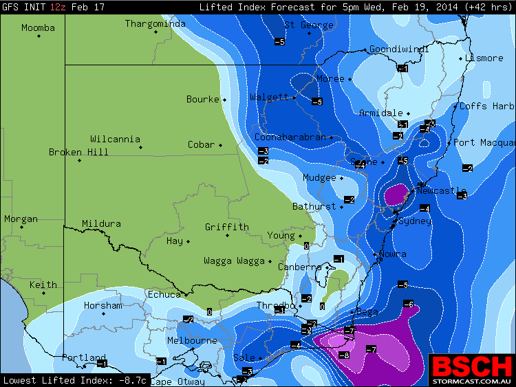
A localised very heavy rainfall event seems now more and more likely to occur from just north of Sydney Central Coast to the lower Hunter Valley. Both models GFS and the Bureau Access R models are placing high precipitation of up to at least 80mm in this region.
The storms may develop rapidly in the afternoon as very moist tropical air combines with surface heating in a possible region of convergence creating instability. Early in the afternoon, the rain event may be northwest of this region in a narrow band in the North West Slopes. The system then centres on the lower and southern Hunter Valley regions about early evening and after sunset. Given there has been at least some rain in these areas on Sunday, any further rain may cause localised flash flooding.
Latest model has the heavy rainfall now within the Sydney metropolitan area! Look out for boundaries tomorrow and the focus for development of storms along those boundaries will create the favourable environment for thunderstorms spawning heavy rainfall! This could also occur during the rush hour period – children pick up time through evening. Just be careful Wednesday.
Latest model has the heavy rainfall now within the Sydney metropolitan area! Look out for boundaries tomorrow and the focus for development of storms along those boundaries will create the favourable environment for thunderstorms spawning heavy rainfall! This could also occur during the rush hour period – children pick up time through evening. Just be careful Wednesday.
An intense rain cell passed over Auburn / Granville on my way home from work after 5 pm. There was water cascading across the road as stormwater drains could not handle the intensity of rain. No thunder claps heard or lightning observed. This was just an intense rain cell. The BOM rain plots to 6 pm for Metropolitan Sydney shows 24 mm of rain falling in that area following the event. It is also identified that Newcastle City (CBD) has had more than 60 mm from this event but this is very localised. The rest of Newcastle has had much less similar to what has occurred over much of Sydney. Finally, there appears to be a fall of 76 mm from a thunderstorm around Canberra.
An intense rain cell passed over Auburn / Granville on my way home from work after 5 pm. There was water cascading across the road as stormwater drains could not handle the intensity of rain. No thunder claps heard or lightning observed. This was just an intense rain cell. The BOM rain plots to 6 pm for Metropolitan Sydney shows 24 mm of rain falling in that area following the event. It is also identified that Newcastle City (CBD) has had more than 60 mm from this event but this is very localised. The rest of Newcastle has had much less similar to what has occurred over much of Sydney. Finally, there appears to be a fall of 76 mm from a thunderstorm around Canberra.