
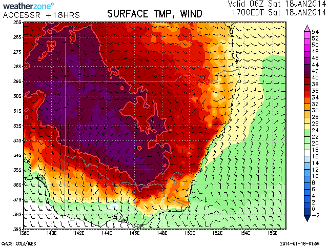
 Emergency warnings are still in place for regions in north western Victoria and eastern South Australia as bushfires threaten communities with the wind change causing the concerns. In NSW, particularly the inland, it will be very hot with expected maximum temperature at Ivanhoe to hit 44C and many other locations to reach into the low 40s. Some farmers are suggesting that this drought is more severe than many other droughts given the extent of the lack of rain and intense heat! The situation is critical across most of Australia with some areas receiving very little if any rain.
It seems, the end is in sight for some locations as the tropical low winds its way down western Australia dragging tropical moisture and introducing cooler conditions across the interior. Another trough of low pressure may develop in NSW in several days into early next week with the possibility of widespread moderate rainfall.
It seems Albury is expected to hit the low 40s today – canberra 40C. Quite hot!
Further to this, its already 37C in southern NSW at 12 noon. If the 40 degree temperature is reached in this region, according to records, it will be the longest stretch of 40C days ever recorded. Looking at the records, over the past 40 years there is a run of 4 days last year 2013, 2009 and 1987. It appears that there was a 4 day run in January 1939 as well. That achievement is under threat at the moment. I do stress, it has been hotter as there was a 44.8C Feb 9 (2009) and a 44.6C on 3 January 1990 and according to the local paper, 46.6C on 13 January 1939. Those very extreme temperatures will not be broken during this current episode.
The cool change will only slowly make its way through Southern NSW. It is suggested that Wagga Wagga wil have one more day of 38C on Sunday. It seems that the dome of heat will push towards the Central West today through to Monday giving Dubbo a possible 3 days of 38C plus temperatures before cooling down after Monday. It is interesting to note that temperatures along coastal Victoria are only between 19C and 22C at 12 noon. A big difference when compared to 12 noon on Friday.
Further to this, the temperaure at Albury Airport has reached 40.2C at 1.30 pm today and 40.5C at 2 pm. It gives this region 5 consecutive days of 40C temperatures and a new local weather record for the most number of 40C days in a row – Now stands at 5.
Another record tumbles! western Sydney is hot again but nothing unusual. Looks like 1939 made its impact on many locations around Australia with many records set at that time.
Today Penrith reached 39.9C at 3.30 pm, 40.6C at 4 pm and right on 40C at 4.30 pm. Badgereys Creek reached 38.7C. Across Sydney, the higher temperatures are relatively limited in extent. Canberra has reached 39C at 3.30 pm before some storm activity but with little rainfall and Wagga Wagga reached 41.7C. The heat reached into far western Sydney but again the coast has been spared. There is some thunderstorm activity around Cooma north towards Canberra as well as some activity over the Central Tablelands but these seem to be high based producing little rainfall so far. Interesting Cabramurra has reached 30C again which is warmer than that at Observatory Hill Sydney. This is likely to be the last day that this occurs as the cool change will now move through.
I must say I don't recall a period of time that spans the most part of 6 months with little rain and just a brief period of rain in between probably since 1982 at this latter time of the year! And this drought seems to be effective across a major part of the country at least towards the east and southeast but it seems also across the Top End. Any thoughts?