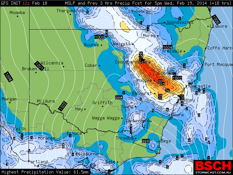
It seems rain is still likely to occur to provide top up rain from the previous rainfall from last Sunday. There is the chance of localised heavier rain with thunderstorms but the likelihood of very heavy rain along substantial boundaries are not favoured on both models. The GFS has still sided with heavy rainfall in the Hunter Valley and North West Slopes but not supported by the Bureau models.
Update:
So what eventuated from this event - 50mm fell at Gosford during the heavy rain and storms as well as a heavy fall in Nobbys Heads.
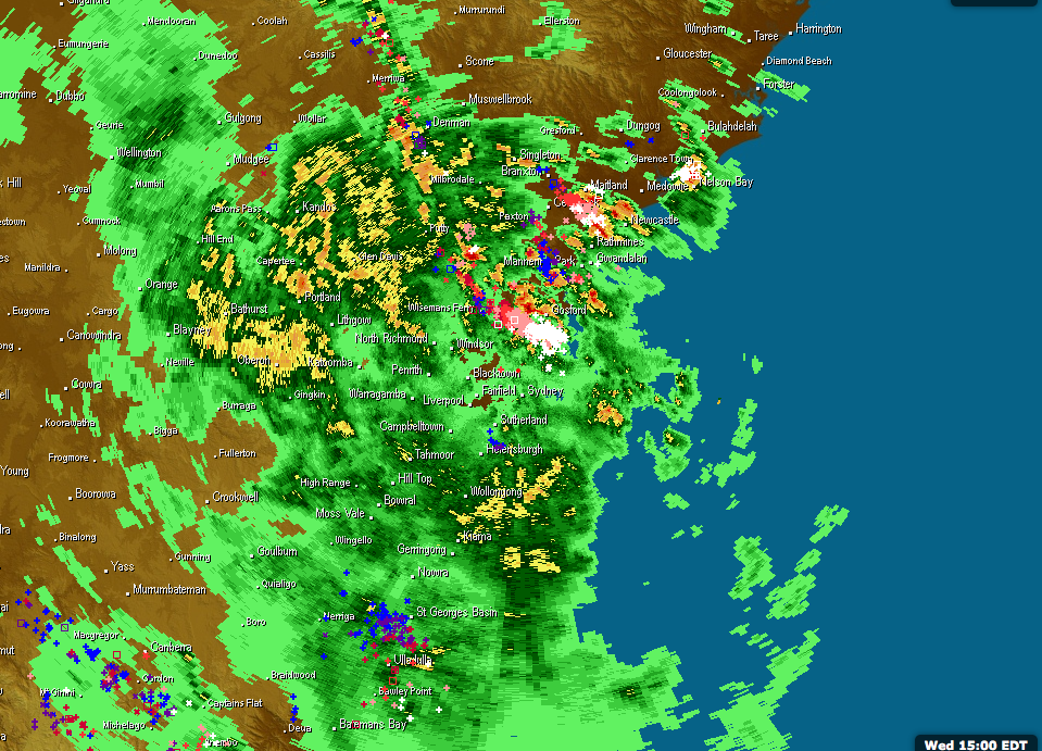
Here is the radar from about 3pm - a dense active area of lightning near Gosford this afternoon
Today it is going to be very humid with dew points in the 22 to 23C range with the Bureau Access model even suggesting 24C – welcome to the real February.
Band of rain NW if Putty and heading SE towards Sydney. More activity in the NW Slopes and also developing in the Hunter Valley.
Latest GFS models again has substantial falls of rain across Sydney of the order of 40mm or more across the region. The soundings are railway tracks or moist all the way up. 2pm soundings indicate sufficient instability in Sydney and precipitation beyond 27mm above 3 hours. So it will be interesting to see what occurs this afternoon – it might get interesting during rush hour.
Interesting to see the bands of heavy rain and the associated warnings on the Central Coast!
Tuggeranong (Southern Canberra ACT) has been drenched in what appears to be two thunderstorms or rainstorms. Either way, the totals for Tuggeranong Town Centre are impressive as follows:-
1.48 pm – 4 mm.
1.50 pm – 6 mm.
2.30 pm – 49.4 mm (That is 43.4 mm in 40 minutes).
3 pm – 63.6 mm.
3.30 pm – 65 mm (The storm is certainly easing by this time).
4 pm – 65.6 mm.
4.30 pm 66.4 mm.
5 pm – 74.2 mm.
5.30 pm – 75.8 mm (The second storm is nowhere near as intense). The first storm would have created havoc and possibly localised flash flooding.
This appears to be highly localised as nearby rain guages show much less rain in the vicinity of 25 to 49 mm range.
On my way home from work today, an intense raincell has passed over Auburn / Granville but no thunder heard. Rain guages in that area shows at least 24 mm to 6 pm. The downpour did cause water to overflow stormwater drains and slow traffic for a period as it passed over.
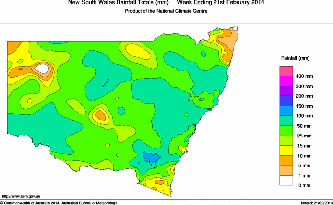
I have added a rainfall totals map for the week that best illustrates the rainfall and how widespread it was across NSW!