Weather models appear to identify a possible rain event across inland New South Wales and Northern Victoria for the period covering 17 and 18 April 2015.
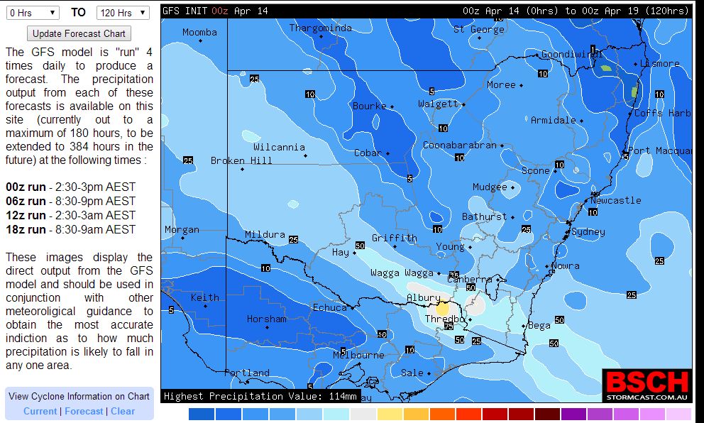
In particular, when reviewing models at the present time, it is identified that a large portion of southern and western New South Wales and the northern border regions of Victoria stretching from the Great Dividing Range north west to Broken Hill is earmarked to receive useful rains. The model posted from GFS (attached) is similar to the Bureau of Meteorology model in which it suggests falls within the range of 25 to 50 mm across the region with higher totals across the ranges of the Great Dividing Range.
Longer range models even suggests an east coast low forming by Monday 20 April with more rain being concentrated along the New South Wales South Coast.
If this eventuates, this could be important given that it could mark the term "The Autumn Break" meaning the first big rain event after a dry summer. Farmers rely on the Autumn break to replenish moisture into dry soils and to establish cropping lands for the new season. This year given that models are indicating an El Nino year which brings drier than normal conditions, this event if it eventuates could potentially be crucial for some of the southern farming regions of the Murray Darling Basin.
Weather forecasts are suggesting showers or rain conditions for places like Albury, Wagga Wagga, Temora, Tumut, Hay during the Friday and Saturday period from this event.
http://www.extremestorms.com.au/possible-nsw-rain-event-17-and-18-april-2015/
http://www.extremestorms.com.au/possible-nsw-rain-event-17-and-18-april-2015/
http://www.extremestorms.com.au/possible-nsw-rain-event-17-and-18-april-2015/
Hi Harley you beat me to it – it looks like rain could be widespread then followed by more rain further east – will see how the models react!
Hi Harley you beat me to it – it looks like rain could be widespread then followed by more rain further east – will see how the models react!
Hi Harley you beat me to it – it looks like rain could be widespread then followed by more rain further east – will see how the models react!
This system is delivering or has delivered a rain event along a narrow corridor of southern New South Wales and northern Victoria generally consistent with the model provided.
However, it is interesting to note just prior to crossing through southern and western New South Wales, this system delivered some unusual rainfall totals to eastern South Australia but north of the Flinders Ranges. For the 24 hours to 9 am 17/4/2015, the following occurred:-
Quorn – 112 mm.
Black Rock – 100 mm.
Bruce and Orroroo – 92 mm.
Oolla Wirra – 73 mm.
Braemar and Minburra – 72 mm.
Willowie – 63 mm.
Mc Cays Well – 62 mm.
Hawker – 56 mm.
This is remarkable for April considering this area is on the edge of the outback and within or close to the driest regions of the country.
The plot showing this is attached.
This system has pushed through Northern Victoria including the Mallee. In particular, Mildura (Not normally associated with heavy rainfall) received 15 mm of rain to 9 am 17/4/2015 then another 56.2 mm to 6.30 am 18/4/2015.
Heavy rain has been falling across North East Victoria where many areas have received around 50 mm although this is limited to the ranges and the highlands. It is known up until 6.30 am 18/4/2015 that places like Mt Hotham and Mt Buffalo has received in excess of 90 mm. Falls Creek has received 94 mm at the same time.
For places around Yarrawonga and Deliliquin, falls continue with 41.6 mm and 29 mm being recorded to 6.30 am. Even at Albury Airport a fall of 35 mm has fallen.
With rain still falling, this could be termed the Autumn break in some southern New South Wales areas given that this is a sizeable rain event over many hours and an important event given that it is soaking the soils.
This system will continue throughout Saturday.
http://www.extremestorms.com.au/possible-nsw-rain-event-17-and-18-april-2015/#comment-2847 Rain is falling across southern New South Wales and Northern Victoria. This is a significant event and probably termed the Autumn Break given the nature of what is occurring. The heaviest falls are within the ranges. This should continue for several more hours.
http://www.extremestorms.com.au/possible-nsw-rain-event-17-and-18-april-2015/#comment-2847 Rain is falling across southern New South Wales and Northern Victoria. This is a significant event and probably termed the Autumn Break given the nature of what is occurring. The heaviest falls are within the ranges. This should continue for several more hours.
http://www.extremestorms.com.au/possible-nsw-rain-event-17-and-18-april-2015/#comment-2847 Rain is falling across southern New South Wales and Northern Victoria. This is a significant event and probably termed the Autumn Break given the nature of what is occurring. The heaviest falls are within the ranges. This should continue for several more hours.
Harley Pearman, have any flood warnings or watches been issued?
Harley Pearman, have any flood warnings or watches been issued?
Harley Pearman, have any flood warnings or watches been issued?
There are no flood warnings in place and river levels appear to be steady for the Ovens, Kiewa and Upper Murray Rivers.
Please find attached a satellite photo of the event. The cloud mass is extensive across New South Wales and Victoria causing the event. It appears much of the western flanks of the cloud comprises thick cirrus and there is a clearing trend crossing through Central Victoria with drier air pushing through.
Much of this would be nimbostratus cloud. Its interesting to note that at Albury Airport, air temperature and dew points are 17C or close together indicating a very low cloud base.
This system should push further east throughout Saturday.
Please find attached the 24 hour rainfall plot for North East Victoria to 9 am 18/4/2015.
Final totals for the period include:-
Falls Creek (Mt Mc Kay) 97.4 mm.
Mt Hotham 92 mm.
Mt Buffalo Chalet 92 mm.
Mongans Bridge – 69 mm.
Granite Flat 63 mm.
Yackandandah – 58 mm.
Yarrawonga received 43 mm.
Albury 35.8 mm.
Most areas within the hills and ranges have received reasonable totals.
Interestingly, the Bureau of Meteorology has just issued a flood watch only for the Kiewa, Ovens and Mitta Mitta as a heads up should significant stream rises occur but there is no current flooding occurring.
The system will spread further east today and it is likely rain should ease in the affected area.
Hi Harley Pearman that was what I had pre-empt.
Hi Harley Pearman that was what I had pre-empt.
Hi Harley Pearman that was what I had pre-empt.
To conclude this article and event, the system cleared the region by late Saturday. Further large falls occurred across the affected area for the 24 hours to 9 am 19/4/15 including:-
Cabramurra – 40 mm.
Thredbo AWS – 39 mm.
Corowa – 38 mm.
Falls Creek – 37 mm.
Harrietville – 36 mm.
Mt Buffalo Chalet – 32 mm.
Dartmouth – 29 mm.
Hume Dam, Hunters Hill and Wodonga – 28 mm.
As a final cumulative total, Falls Creek received 134.4 mm from the event and Mt Buffalo Chalet had 124 mm.
Rivers in the area did rise but did not reach flood levels and indeed water levels are now stable or falling.
A band of rain did eventually pass through NSW from the event but falls were lighter when compared to those in the south and south west of the state.
The final rain plot for New South Wales for the 24 hours to 9 am 19/4/2015 is attached for the record.