Following recent storms and heavy rain, a dramatic turn of the weather is now developing across south east Australia. The turn of events shows how variable and dramatic weather can be over the space of a few days across south eastern Australia.
A strong high pressure cell now in the Tasman Sea will dominate much of eastern Australia until Saturday. Hot dry north west winds should become a feature and maximum daytime temperatures are predicted to rise to well above average.
When compared to recent days, this is quite significant. It was only last Saturday at Blacktown where the maximum temperature struggled to reach 20C. However by Friday, the maximum temperature may reach 39C. This shows the contrast of what is occurring.
A burst of hot weather is expected to infiltrate much of inland New South Wales and much of Victoria probably except the coastal regions of south east New South Wales being the south coast, far southern coastal Victoria and the higher regions of both states (Alpine areas).
Forecast models and official forecasts suggests temperatures reaching as high as 43C at some inland centres such as Ivanhoe and Tibooburra. Additionally, many centres are expected to have their first 40C days for the summer season including Gundagai, Griffith, possibly Young and even Penrith.
Some maximum forecast temperatures for the three days include:-
Albury - (Wed 34C), (Thu 38C) and (Fri 37C).
Broken Hill - (Wed 39C), (Thu 41C) and (Fri 41C).
Corowa - (Wed 34C), (Thu 41C) and (Fri 37C).
Griffith - (Wed 40C), (Thu 42C) and (Fri 40C).
Gundagai - (Wed 34C), (Thu 37C) and (Fri 40C).
Hay - (Wed 41C), (Thu 43C) and (Fri 41C).
Ivanhoe - (Wed 40C), (Thu 43C) and (Fri 43C).
Penrith - (Wed 36C), (Thu 37C) and (Fri 41C).
Tibooburra - (Wed 39C), (Thu 42C) and (Fri 43C).
Young - (Wed 35C), (Thu 38C) and (Fri 40C).
A feature of the hot spell is:-
1 - It should last three days until a cooler change moves through on Saturday.
2 - It will be more prevalent across the inland.
3 - It will extend to parts of the coast such as Sydney, the Hunter Valley and north coast but the 40C temperatures should remain mostly an inland phenomena.
4 - The south coast of New South Wales is expected to miss much of the heat so places like Ulludulla and Narooma are not expected to experience much heat due to sea breezes.
5 - Far southern Victoria is expected to remain much cooler especially during Thursday and Friday.
6 - The hottest regions are expected to be around places such as Bourke, Cobar, Griffith, Hay, Mildura and Wilcania during the afternoons of Wednesday, Thursday and Friday.
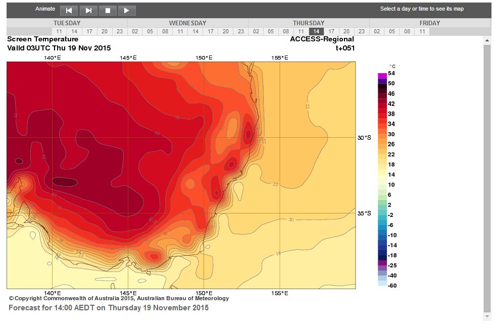
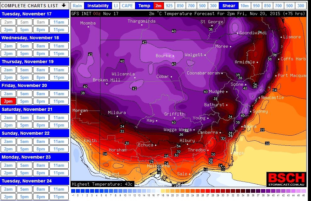
The attached plots show:-
1 - The forecast temperature from the Bureau of Meteorology ACCESS model for 2 pm Thursday afternoon for south east Australia.
2 - The forecast temperature from the GFS model for 2 pm Friday afternoon.
For Wednesday 18 November, some hot to very weather infiltrated much of inland New South Wales, Northern Victoria and eastern South Australia as forecast.
Around Adelaide, maximum temperatures reached between 38C and 40.7C depending in location. At Whyalla (South Australia), it reached 39.6C. Several centres across eastern South Australia saw maximum temperatures reach 40C or slightly higher.
It reached 41.6C at Renmark (South Australia) with dewpoints of minus 6.2C indicating very dry air.
At Mildura in north west Victoria, it reached 40.9C at 3.49 pm and that came with dewpoints of minus 1.4C which indicates how dry the air is. Hopetoun in the Wimmera (NW Victoria) had 40.5C while Swan Hill had 39.5C.
Hay in the western Riverina of New South Wales had 38.2C and Deniliquin had 35.3C.
Further east, the heat was a little less intense and 34C to 36C was common at many centres.
Some of the heat filtered into the Sydney basin and much of Sydney city had between 34C and 36C although Holsworthy had a top of 36.8C.
Interestingly, a weak southerly change impacted the south coast early so places such as Merimbula and Narooma only had 24C as their maximums due to the impact of cool maritime air. That change is only skirting the coastal strip but it does show big differences in temperature due to wind direction.
This hot spell will continue for another two days across most south east areas.
A feature of Thursday 19 November is the late maximum temperature readings from many weather stations and the duration at some centres where the temperature reached or exceeded 30C. For example:-
1 – The maximum temperature at Ivanhoe (NSW) was 42.2C but at 7 pm, it was still 41.2C. That came with dew points of minus 0.9C.
2 – At Deniliquin (Riverina NSW), the temperature reached 39C but it was still 37.5C at 7pm.
3 – At Hay (Riverina NSW), the temperature passed 37C at 12.30 pm but at 7 pm, it was still 38C. A late reading of 40.9C was recorded at 5.30 pm by the local weather station which is a very late maximum.
4 – At Griffith (Riverina NSW), the temperature passed 30C at 9.30 am and it was still 38.3C at 7 pm. The maximum recorded was 40.6C .
5 – At Swan Hill (NW Victoria), it reached 39.9C but the temperature passed 30C at 9.30 and it was still 37.7C at 7 pm.
6 – Mildura has certainly felt the heat in which the temperature passed 30.4C at 9.30 pm. A maximum of 41.8C occurred but at 7 pm, it was still 40C.
This is showing the extent and longevity of the heat across some inland locations.
The heat has spread across large areas of interior New South Wales and northern Victoria and it did reach 38.9C at Yarrawonga and 37C at Albury Airport.
Maximum temperatures over 40C were common at many inland centres including Wilcania.
Much of the South Coast of New South Wales has again missed the heat and moderate temperatures in the low to mid twenties prevailed due to sea breezes. However at Nowra, it reached 39.3C. This was unusual because sea breezes prevailed at centres along the south coast which moderated temperatures considerably.
The heat infiltrated into Sydney again and maximum temperatures peaked very late in the day over 37C across areas of the western suburbs including Penrith, Richmond, Horsley Park, Blacktown and Camden. It reached 38.5C at Penrith and 37.5C at Richmond.
Friday will be the hottest day during this period with 41C forecast for Sydney before a late or evening south east wind change. This will conclude the hot spell for the Sydney region.