 Many areas across eastern NSW are under Total Fire Bans due to continuous long dry spell and heat expected today. There are already many blazes across NSW and with low humidity, expected thunderstorms, lightning strikes may spark new bushfires. In Sydney for instance, temperatures are expected to peak in the mid 30s. Many parts of NSW and Queensland have experienced seriously dry conditions with very little rainfall for more than 3 months. Coupled with high temperatures and strong winds through August and September, this has made conditions very critical.
And there is very little relief in sight with possible high temperatures again expected next weekend! Rainfall is desperately needed to ease drought and the bushfire conditions.
I just got some prompted information from Glen that a bushfire emergency and evacuations are occurring near Salt Ash – a region near Port Stephens.
This was from http://www.rfs.nsw.gov.au/dsp_content.cfm?cat_id=683
Browns Road, Salt Ash
ALERT LEVEL: Emergency Warning
LOCATION: Browns Road and Lemon Tree Passage Road, Salt Ash
COUNCIL AREA: Port Stephens
STATUS: Out of Control
TYPE: Scrub fire
FIRE: Yes
SIZE: 5 ha
MAJOR FIRE UPDATE AS AT 13 Oct 2013 14:56: A bush fire is burning out of control in the Tilligerry State Conservation area and is currently threatening properties in the areas of Browns Road and Lemon Tree Passage Road, Salt Ash. more
RESPONSIBLE AGENCY: Rural Fire Service
UPDATED: 13 Oct 2013 14:05
Mooreland Fire
ALERT LEVEL: Emergency Warning
LOCATION: Mooreland Road, Fingal Bay
COUNCIL AREA: Port Stephens
STATUS: Out of Control
TYPE: Scrub fire
FIRE: Yes
SIZE: 10 ha
MAJOR FIRE UPDATE AS AT 13 Oct 2013 14:43: A bush fire is burning out of control to the west of Fingal Bay. An emergency alert telephone message has been sent to residents in the area. more
RESPONSIBLE AGENCY: Rural Fire Service
UPDATED: 13 Oct 2013 14:37
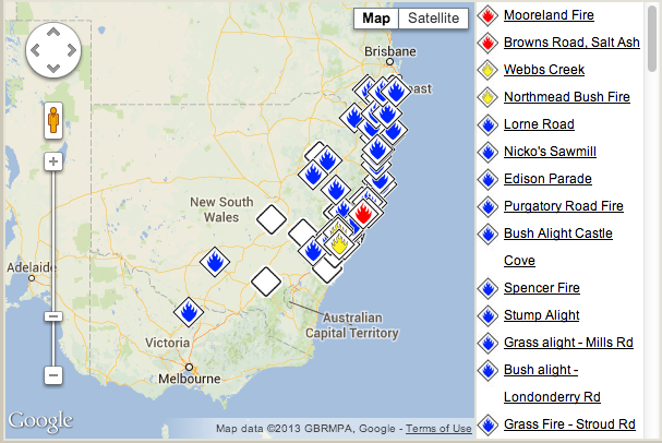
Here is a map with locations of the bushfires for today.
Temperatures on Sunday were well above the average across large areas of NSW especially Sydney, Hunter Valley and North West of the state. The highest temperatures recorded were 37C at Walgett and Lightning Ridge. Williamtown (Newcastle) recorded 36C while much of Sydney enjoyed 34C to 36C range with Penrith recording 35.2C.
A big feature of the day were the hot dry NW winds coming ahead of the cold front. Another feature were the very low dew points. In particular once the NW winds had become established dew points fell into the negatives which included:-
Penrith – Negative 5.2C.
Bega (South coast) Negative 3C.
Cobar – Negative 10C.
As samples. Dew points only increased once the cold front approached and cloud cover increased.
A small number of fast moving thunderstorms preceded the cold change around the Gunnedah / Tamworth / Quirindi region but dropping little rainfall.
Overnight Sunday / Monday, the change passed over Sydney which brought very little rainfall across Western Sydney but falls of 2 mm to 7 mm were evident closer to the coast.
It is interesting to note that the weather event of Sunday 13 October was a carbon copy of the weather of Thursday 10 October that saw temperatures reach up to 36C to 37.8C across Sydney which preceded a dry cool change for Friday.
This has been the trend for September and October to date which has already seen 13 days of 30C temperatures for the season at Blacktown as at 16/10/13 with more similar weather on the way.
At Blacktown where I live, the maximum daytime temperatures leading up to the 13 October have included 31.4C (9/10), 36.8C (10/10), 24.7C (11/10), 31.3C (12/10), 34.6C (13/10), 21.2C (14/10), 25.6C (15/10) and at least 31C for the 16/10. This shows a wide maximum temperature swing for the corresponding days over such a short period. A feature has been 1 or 2 days of NW winds preceding a dry wind change for 1 or 2 days then a return to the hot dry weather.
Either way, the stand out days have been the 10/13 for the 37C day for Sydney and the 13/10 for the heat / wind and such low dew points.