 A significant rainfall event is expected to develop over eastern NSW during the 14th to 15th October 2014 in response to rapid cooling in the upper atmosphere and onshore winds in the southern part of the low. Rain fall totals may exceed 100mm in regions along the Hunter Coast with pockets of 150mm being predicted. The Hunter region had received very little rain during the past month or so so this would be a case of too much rain too soon and probably will lead to flooding along the coastal parts.
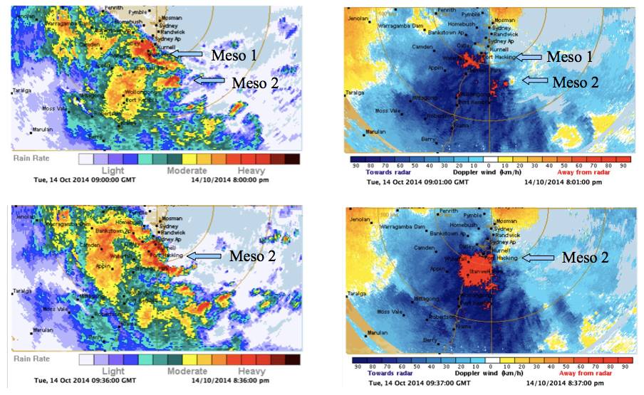
Update: An intense east coast low complete with couplets on doppler radar. Very strong winds were reported from near Wattamolla to Kurnell with winds of the order of 130km/h in one observation! 161km/h from the south! The circulation passed near the Sydney Airport with very heavy rain accompanying the winds as well as cloud to ground lightning! In the Blue Mountains, snow and ice has caused the closure of both the Great Western highway and Bells Line of Road! Temperatures were hovering near and below 0.5C with precipitin most likely snow!
128km Sydney reflectivity radar
See : 128km Radar Loop for Sydney (Terrey Hills), 11:00 13/10/2014 to 11:00 14/10/2014 UTC

64km Sydney reflectivity radar - check out the spiral bands
See : 64km Radar Loop for Sydney (Terrey Hills), 11:00 13/10/2014 to 11:00 14/10/2014 UTC

128km Sydney doppler radar scan
See : 128km Radar Loop for Sydney (Terrey Hills), 11:00 13/10/2014 to 11:00 14/10/2014 UTC

A significant rain / storm event certainly passed over Sydney last night. Please find attached the rainfall figures for the event although the final figures for 9 am 15/10/2014 includes some morning showers across parts of Eastern Sydney.
The heaviest totals include:-
Bundeena – 142 mm.
Oatley – 127 mm.
Marrickville Golf Club – 124 mm.
Canterbury – 121 mm.
Strathfield – 116 mm.
Airport and Little bay – 101 mm.
Carnarvon Golf Club – 96 mm.
Royal National Park – 91 mm.
Riverview – 76 mm.
Where I live in Blacktown, big falls of 56 to 60 mm occurred to give a comparison.
This does not tell the full storey.
Today, Auburn Council’s Drainage Engineer analysed the rainfall figures for the Carnarvon Golf Club at Lidcombe which is within the Council jurisdiction. Here, 95 mm fell during the event which excludes the morning showers. It is found that 73 mm of that fell between 9 pm and 12 midnight. That has fallen 2 mm shy of a 1 in 10 year event. It is rated between a 1 in 5 and a 1 in 10 year event, closer to a 1 in 7 or a 1 in 8 year event when considering the flooding impact.
A weather station at Sans Souci being a public school recorded 61 mm between 6 pm and 9 pm and 66 mm between 9 pm and 12 pm which is a significant event. A weather station at Canterbury recorded 91 mm between 9 pm and 12 midnight, effectively 30 mm per hour for 3 hours. A weather station at Little Bay recorded 61 mm during the same period (An average of 20 mm/h for 3 hours).
One other interesting recording is Strathfield where 88 mm fell between 9 pm and 12 midnight which is just under 30 mm per hour.
This demonstrates the intensity of the storm across pockets of Sydney under the more intense cells at up to 30 mm per hour and hence the problems that occurred.
I did observe some degree of flooding at Auburn on my way to work across parklands adjacent to Duck River in Mona Street.
This storm was interesting because I have personally never seen such a storm in such an environment with an east coast low out to sea over so many hours. There were a number of lightning strikes and some very loud thunderclaps.
In addition to the Sydney event, some big rainfalls occurred further south earlier in the day especially around Narooma on the South Coast including:-
Barlows Bay – 153 mm.
Narooma – 127 mm.
Regatta Point – 126 mm.
Central Tilba – 118 mm.
The figures are till 9 am 14/10/2014.
Heavy rain later spread to Ulladulla with 129 mm falling between 9 am and 6 pm 14/10/2014 and 152 mm at nearby Lake Conjola during the same period (An average of 25.5 mm per hour).
It is identified though that the very big falls in excess of 100 mm are indeed hit and miss and only a few localities received the very big totals.
Wow Harley Pearman – incredible rainfall totals for a short time event as well as powerful winds!
Wow Harley Pearman – incredible rainfall totals for a short time event as well as powerful winds! Thanks for posting the rainfall statistics on the page!
Wow Harley Pearman – incredible rainfall totals for a short time event as well as powerful winds! Thanks for posting the rainfall statistics on the page!
Some of the rainfall totals are impressive for the short duration.
The event at Sans Souce has also been analysed in which 127 mm fell between 6 pm and 12 midnight. It is determined using the Rainfall Intensity in MM/HR and Return Periods Table that the rain guage appears to have recorded a 1 in 20 year event for that locality for a 6 hour rain event.
Strong winds were also a feature. The media has reported a wind gust of 161 km/h at Wattamolla in the Royal National Park but I could not verify that. However, I have verified some strong wind gusts at 2 coastal weather stations being:-
Sydney Airport
10.19 pm – Wind gust to 106 km/h.
10.36 pm – Wind gust to 107 km/h.
11.30 pm – Wind gust to 106 km/h.
3 am (15/10/14) – Wind gust to 102 km/h recorded.
Average wind speeds are much lower but these are peak wind gusts.
Bellambi (Illawarra)
9.43 pm – Wind gust to 100 km/h.
6.59 – 7.01 am (15/10/14). Several wind gusts to 102 km/h recorded.
Hi Harley Pearman, is it true that after the 161km/h gust that of peculiar behaviour in direction occurred from the east and north when really it should have been from the southerly direction?
Hi Harley Pearman, is it true that after the 161km/h gust that of peculiar behaviour in direction occurred from the east and north when really it should have been from the southerly direction?
Hi Harley Pearman, is it true that after the 161km/h gust that of peculiar behaviour in direction occurred from the east and north when really it should have been from the southerly direction?
Jimmy, I am unable to locate the wind data for the weather station despite some detailed research. Probably if I had viewed it within 2 days after the event, I could give you a better answer.
However, I have found through the Australian Weather News that a wind gust of 161 km/h is confirmed (Roughly 87 knots) at 9 pm at a direction of 180 degrees / 132 degrees (Southerly / south east direction). Some other reports suggests it occurred at 9.02 pm but direction not given.
I have also found that another gust of 135 km/h is recorded here but direction is not given at 9.10 pm.
Interestingly at 8.52 pm when viewing the Australian Weather News data, a wind gust of 115 km/h is recorded at Kurnell which is not too far away from a direction of 290 degrees / 72 degrees (Another direction). It appears that something of interest was going on with respect to winds in the area.