
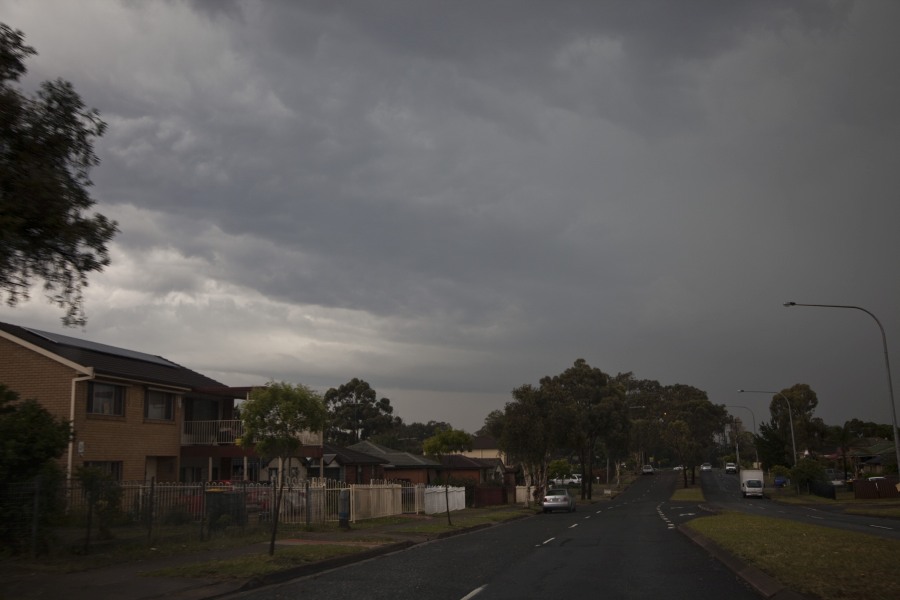


 With an upper trough approaching the region, heat and moisture at the surface, conditions were ideal for thunderstorm development from early afternoon. In fact, numerous storms developed across the Central Tablelands and approached the Sydney region. One cell in particular showed signs of intensifying and moved left along what seemed to be a boundary. This cell had developed rapidly and a rain free base developed Londonderry with possible hook echo signature on radar. The storm was reasonably active lightning wise and continued to move towards Box Hill. Hail was reported in Riverstone as I drove through confirmed by Nick Moir. I ventured further north positioning near the possible second hook echo where slightly larger thumps occurred in the Box Hill vicinity.
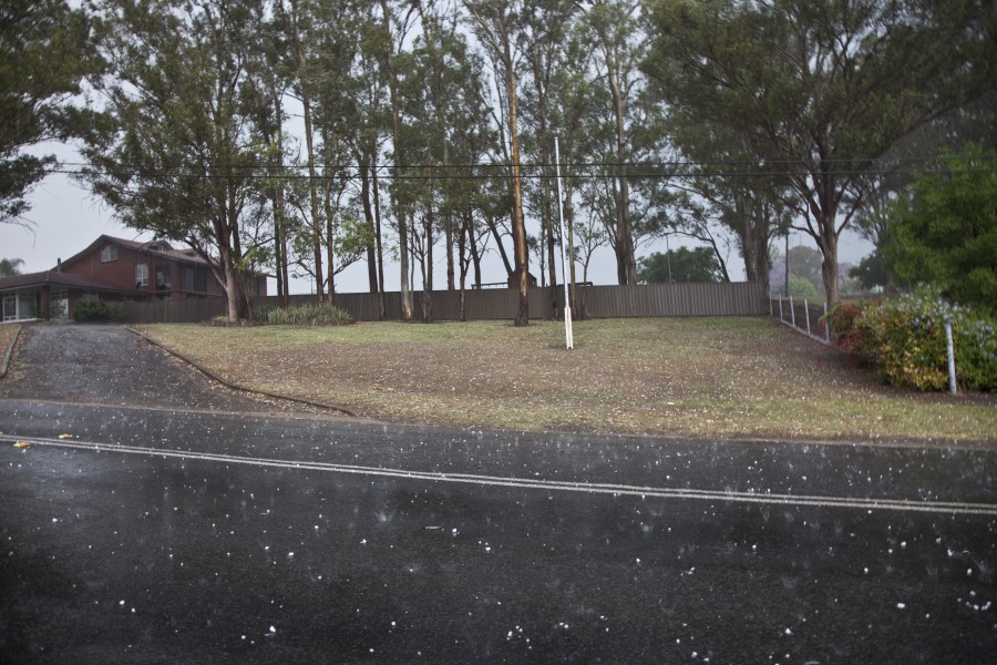
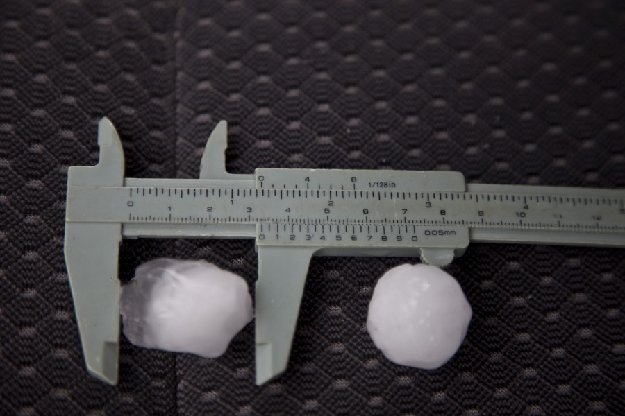
While in this region, I did not pursue the cell towards Glenorie and simply decided to measure the hailstones further back in the main path. Hail was measured at maximum 3.3cm in diameter.Strangely enough, I look across the road and there was what looked like a larger one! I crossed the road only to find an actual golf ball - a real golf ball, and another one and another one - probably about 6 to 8 golf balls outside of a farm fence was just wierd! I have never observed this in all my years of storm chasing!
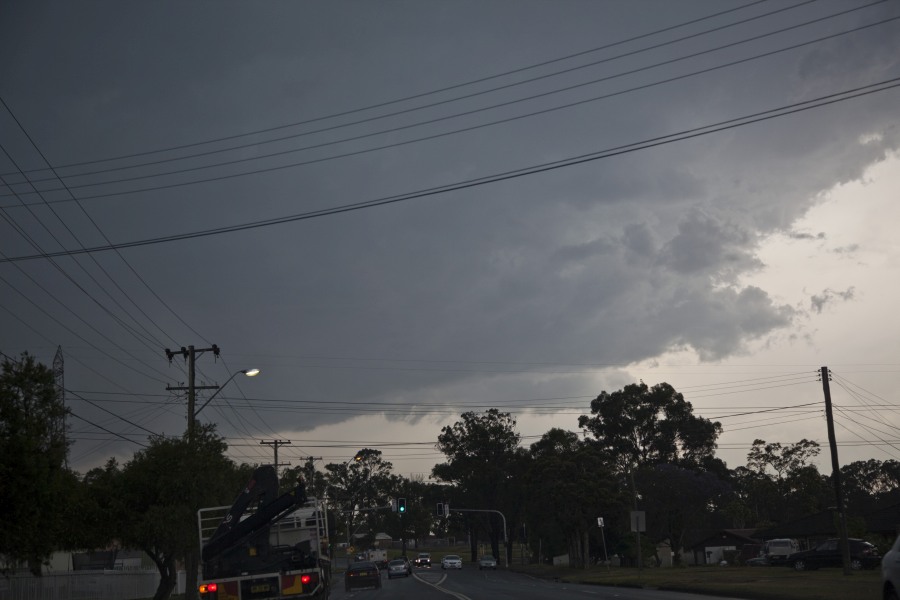
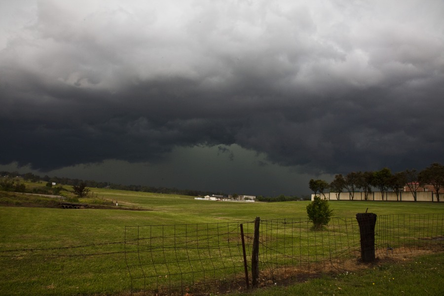
Moving further along the path, its seems the hail sizes were consistent. Looking generally southwest, out of the haze it seemed another cell was approaching. Trying to find another vantage point was fruitless and amazingly, the storm had made its presence known quite quickly - this storm was moving in rapidly.
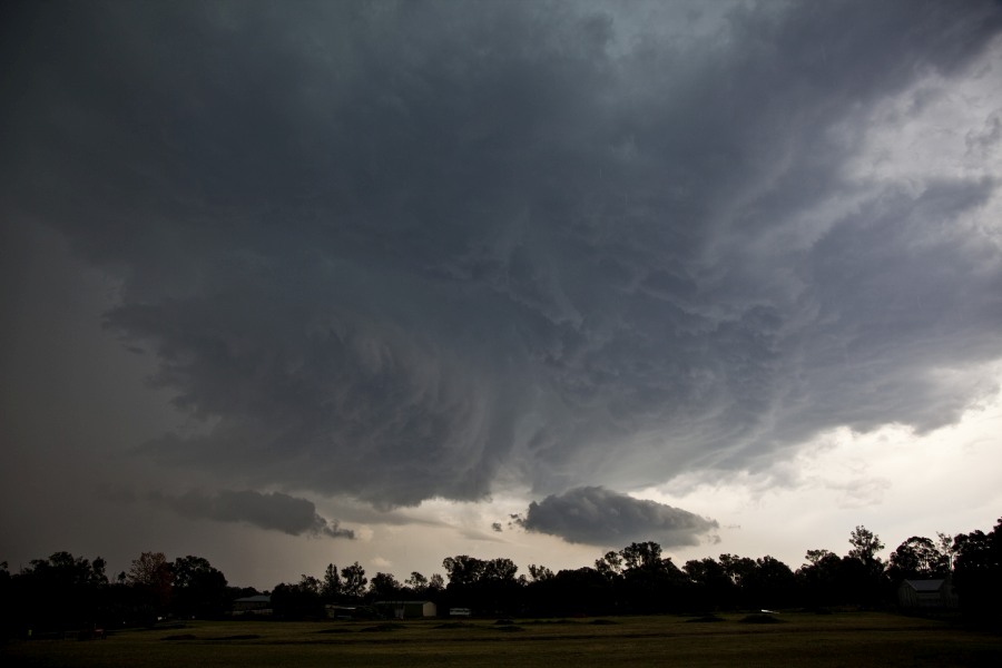
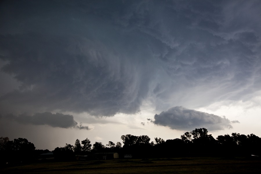
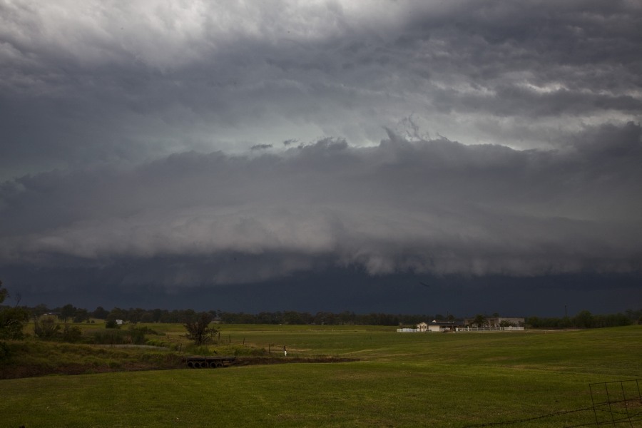
Finding a position not far from the measured hail, tripod was set up filming for immediate time-lapse. The storm had appeared out of the haze and was a sculptured shelf cloud structure. As the low base appeared, lightning could be observed pulsating behind. A bowl lowering also appeared on the south side of this particular storm segment. Time-lapse was shot of this lowering but alas nothing significant in terms of obvious rotation picked up. The shelf cloud spread overhead and rapidly moved northeast. Some strong pulsating lightning bolts were observed as the shelf cloud became less defined. Some intense precipitation was also observed to my west and northwest that came from another core.
Initially giving chase, it was evident this was a mass of rain and storm activity and I turned back meeting with Nick Moir for an evening pizza with discussions of the storm chase.
See : 128km Radar Loop for Sydney (Terrey Hills), 21:00 04/11/2014 to 21:00 05/11/2014 UTC

See : 64km Radar Loop for Sydney (Terrey Hills), 21:00 04/11/2014 to 21:00 05/11/2014 UTC

See : 128km Radar Loop for Newcastle, 21:00 04/11/2014 to 21:00 05/11/2014 UTC

Added a video http://youtu.be/4BBViLMtvh4
A couple of shots from yesterday, 1st is from the intense lightning around 1500 at Parramatta
the 2nd shot is from the storm that produced hail in Sydney’s NW , it had nice structure and inflow courtesy of the NE inflow the photo was taken at 1545,
Hi Con, that is an awesome strike! Nice structure also with this fast moving severe storm.
Hi Con, that is an awesome strike! Nice structure also with this fast moving severe storm.
Hi Con, that is an awesome strike! Nice structure also with this fast moving severe storm.
Hi Con, that is an awesome strike! Nice structure also with this fast moving severe storm.
Thanks Jimmy, Yes they were fast moving , I’ve included another shot with a bit better contrast, certainly brief but organised before outflow took over.
Thanks Jimmy, Yes they were fast moving , I’ve included another shot with a bit better contrast, certainly brief but organised before outflow took over..
Yes very compact system given the speed it moved and the inflow causing good relative inflow for a short period! Here is the video of mine added to the report http://youtu.be/4BBViLMtvh4.
Yes very compact system given the speed it moved and the inflow causing good relative inflow for a short period! Here is the video of mine added to the report http://youtu.be/4BBViLMtvh4.
Yes very compact system given the speed it moved and the inflow causing good relative inflow for a short period! Here is the video of mine added to the report http://youtu.be/4BBViLMtvh4.
Yes very compact system given the speed it moved and the inflow causing good relative inflow for a short period! Here is the video of mine added to the report http://youtu.be/4BBViLMtvh4.
Please find an account of this event.
Wednesday afternoon, I took a half day flexi and left work just after 12.30 pm. Looking to the west, I saw two small thunderstorm towers in their developing stage so I decided to head along the M4 Motorway and drove to Penrith.
I turned off the M4 Motorway at The Northern Road and drove south to a newly developing suburb around Mulgoa. I turned into the suburb and found a good lookout and watched the storm develop further. By this time, the northern cell had weakened but the southern cell began to consolidate and intensify.
Even though this was an insignificant storm at this stage, it appears that this set the stage for a later storm. The photo below shows the storm in its initial stage.
At this location, I was experiencing light rain but the raindrops were quite large and rumbles of thunder were audible within the cloud.
This storm being the first at around 1.30 pm does not look significant but the second photo shows the same cell but later as it began to pass over me. I then relocated further west.
As I was driving west, I saw an impressive and a powerful cloud to ground lightning strike in front of me but further west striking something within the nearby hills. I thought there would be more but there were not. This produced a powerful thunderclap.
The rain core passed over me bringing a substantial shower but it was localized with no hail.
Even though this was occurring, I had the impression that the environment within the area was not ruined. All the time, I could see another separate storm cell encroaching into the area from the north west.
Thanks Harley Pearman for posting the report of your chase before the big storm occurred. This was what I saw from Bidwill to a certain extent! Then it took off big time!
Thanks Harley Pearman for posting the report of your chase before the big storm occurred. This was what I saw from Bidwill to a certain extent! Then it took off big time!
Thanks Harley Pearman for posting the report of your chase before the big storm occurred. This was what I saw from Bidwill to a certain extent! Then it took off big time!
Thanks Harley Pearman for posting the report of your chase before the big storm occurred. This was what I saw from Bidwill to a certain extent! Then it took off big time!
I attach the radar image of this courtesy of work staff who Emailed this to me as the storm was at its peak.
The cell barely to the south of Penrith was of interest. The photo above almost correlates with this cell as shown on radar.
I am underneath that cell showing red on the radar. It produced a strong downpour where I was.
I was aware and could see the cells further south but elected not to pursue that.
As the storm traversed south east, it went into decline. The next storm to the north west began to show signs of rapid development and I had a good view of it. Its base was relatively high.
Following the first storm, I did note a new burst of sunshine and there were enough breaks in the cloud to allow new heating to occur. As this was occurring, I elected to drive north along The Northern Road towards Richmond.
Jimmy, this is the storm that produced the hail but it is in its infancy as it comes off the Lower Blue Mountains. I was watching a separate storm cell to the north east but let that one go as I favoured the one coming off the Lower Blue Mountains.
I also have the Penrith weather station records available which I will add which is interesting:-
1 pm – Temperature of 28.6C with 16.5C dew points and 48% humidity with a peak wind gust of 11 km/h from the ENE.
2 pm – Temperature of 25.6C with 18C dew points and 63% humidity with a peak wind gust of 15 km/h from the south.
At 2.30 pm, the dew points peak at Penrith of 18.6C but the temperature falls to 22C here.
The dew points increase at the weather station after the initial storm cell passed and left the area.
This storm rapidly intensified as it came off the Lower Blue Mountains with new updraft towers and a thickening base which lowered. I skirted the edges of the rain shaft receiving rainfall intensities that varied as I drove further north. I did not experience any hail.
I could see an interesting base develop on its NW side and that was of particular interest to me.
I was stuck behind a slow driver but just north of Londonderry, I turned left and into a rural area and captured this cloud base on its extreme north west side. This had developed a green tinge.
A powerful lightning flash very close to me occurred with an ensuring instant thunderclap. I proceeded to take a sequence of photos and even some video of lightning.
This cloud as it developed further passed over me and I received a hail event. However I was in an area where the hail commenced to fall and so there was more hail further east and south but none further west. The stones were approximately 1 cm in size at this location.
It was not possible to pursue the hail east due to the road network, the 40 km/h school zones in play and traffic.
The photos above shows how the storm developed from a high base to what I see just outside Londonderry looking west / south west. That passed over me as it developed further.
I then drove further north and stopped to captured more images of the north west portion of the storm with its updraft towers.
This is another image of the updraft towers and inflow feeding into the storm cell as it moved SE. I saw many cloud to ground lightning strikes.
Following this, I saw an interesting storm developing further south so I headed back south and eventually towards Penrith. I realized that it was a squall was coming through at rapid pace.
I saw some very dark cloud bases but no opportunity to stop to photograph them.
Despite the traffic, I turned around and headed north along Castlereagh Road. I managed to barely keep ahead of it to Richmond. At Richmond, traffic slowed me down. The storm began to overtake me as I passed through Winsdor in slow moving traffic.
I then attempted to drive north along Putty Road to near Colo Heights to see if it was possible to get ahead of it but the squall had overtaken me. Upon seeing the cloud turn white to the west, I knew that it had overtaken me completely so I stopped and let the squall go. I returned home.
I certainly experienced heavy rain within the squall with much lightning around me as I drove towards Colo Heights.
This concluded the chase.
I did stop and take this image of the squall at Richmond before it came through.
It is also appropriate to provide some weather readings for Richmond at the time because they are interesting too.
Richmond Weather Observations (ID67105)
1.30 pm Temperature of 29C with 15.5C dew points. Humidity at 44% and a peak wind gust of 30 km/h from the ESE.
2 pm Temperature of 24.9C with 17.6C dew points. Humidity soared to 64% with a peak wind gust of 46 km/h from the ESE.
Dew points at Richmond peak at 18.3C at 2.14 pm.
At 2.56 pm here, the temperature is only 22.9C with 16.7C dew points but there is a peak wind gust of 76 km/h from the south west.
Rainfall readings
In terms of rainfall the heaviest totals occurred around Wilmott and Penrith where 34 mm and 30 mm fell. Much of the area around Blacktown received between 11 and 16 mm.
There is a reading of 28 mm near Erskine Park and 27 mm near Bossley Park.
The heaviest totals are by far within the far Western Suburbs of Sydney.
Lights falls occur on the coastal suburbs including 2 mm at La Peruse, 5.4 mm at Bondi and 4 mm at Narrabeen.