shelf cloud taken from Bondi Junctionas a line of storms made their way into sydney

Severe Storms and Storm Chasing
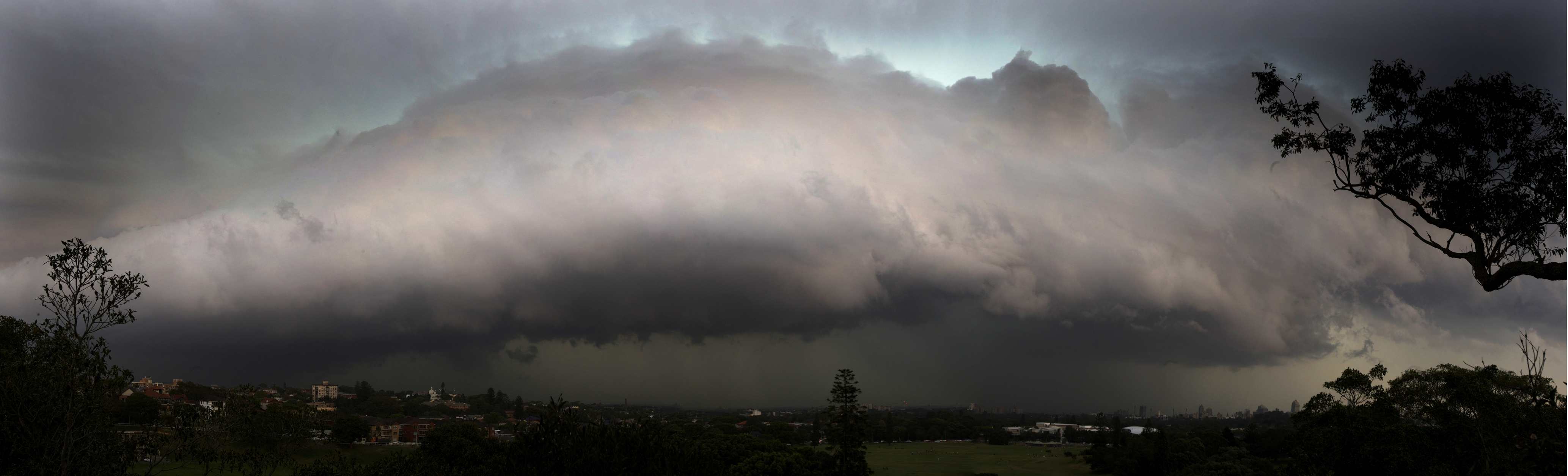
shelf cloud taken from Bondi Junctionas a line of storms made their way into sydney
Photographer for Fairfax Media and Oculi.com.au specialising in severe weather and bushfires
You must be logged in to post a comment.
Nice pic Nick, looks intense, Mustve been pretty bad up there for Sydney Airport to shut…Ive got some pics on the camera of the nice front over Batemans Bay, I’ll upload them tomorrow. It only brought some Rain, Thunder, and about 2 bolts of lightning and not much else for maybe 1 hour max… Havent had a good storm down here for a while, wouldve been nice if it developed a little further, it looked fairly intense just west of the ranges but then died off over the Bay… On the radar (same as belows link) you can see it sort of have a little clear-ish passage over Batemans Bay only to close up again once its gotten passed the town.There was a tornado at Bombala on the south coast too, radar doesn’t seem to show much except for a small intense cell, (bottom right just inland from the coast) at about 01:20 GMT Im guessing would be the cell in question… http://www.theweatherchaser.com/radar-loop/IDR402-canberra/2011-11-07-10/2011-11-08-10And this is the only news report I can find of it, which has pictures of the damage and the Tornado, http://www.bombalatimes.com.au/news/local/news/general/bombala-twister/2351241.aspx
Bombala tornado video
http://www.youtube.com/watch?v=CZwZSpaYIpo
http://www.youtube.com/watch?v=5CJb4SIeRuI
Regards,
Jimmy Deguara
The following are from storms from near Picton through to near Wollongong before it hit Stanwell Tops hail barrage!


Regards,
Jimmy Deguara
Great shots guys!!!Jimmy I must have not been far behind you.. came down to Stanwell from the Hume highway. Saw similar structure but did not get any hail. Copious amounts of CG’s in the Cronulla area however as the line moved through there!! Was quite spectacular.
To add to Jimmy’s post I’ve got a video of some interesting storm motion including rotation in a wall cloud like feature near Mt Kiera.
http://www.youtube.com/watch?v=USmh26Ga7yE
Jeff.
Thanks for that Jeff. If you get a chance, I would not mind seeing the hail footage.
Regards,
Jimmy Deguara
Hi Jimmy,Here is the hail footage.
http://www.youtube.com/watch?v=hN-szyFxOlE
Jeff.
Nice shots above guys. I was pretty busy at work and forgot about the developing storms until Jimmy and Jeff reminded me. I grabbed the camera and raced up to the top level of the car park at work and grabbed some video of the approaching cell. Nice gust front and plenty of lightning to go with it.

 Tonight (9th) a little cell developed at dusk over the western suburbs and tracked towards Port Hacking – packed a lot of CGs

Haha, I realised after watch the video footage a few time that the sign that blacks out is actually a speed warning sign that omes on the warn you if you are speeding :-)
Heading Towards Wollongong


Parked near Mt Ously looking South East
On Appin Road watching new updraft developing
New updraft has south east and north east inflow and develops rapidly