
Typhoon Soudelor has weakened from a Category 5 storm "Super typhoon" to a Category 2 storm quite rapidly. The storm is now currently 20.43 degrees north and 130.97 degrees east and models are now suggesting that the storm will approach and make landfall over the east coast of Taiwan.
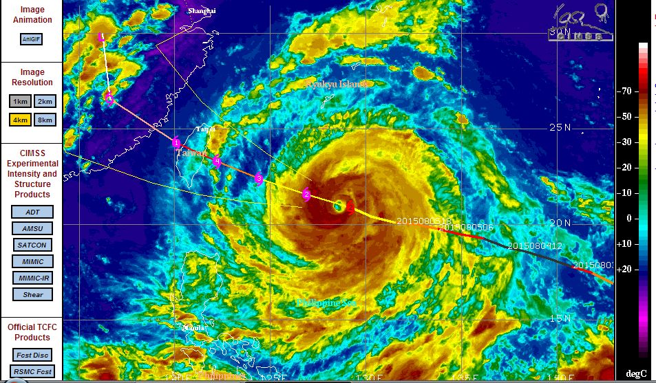
The attached CIMSS model acquired 6 August is showing a much weaker storm than that 2 days ago with sustained winds of 95 knots close to the eye (Approximately 176 km/h). However it appears that the storm is sustaining higher peak wind gusts of 115 knots (Approximately 213 km/h) near to the core.
Upon reaching a powerful category five storm, the storm attained winds of 155 knots (Approximately 286 km/h) with higher gusts estimated at 190 knots (approximately 350 km/h to 354 km/h).
However this only lasted for a period of one day. It is interesting to note that sea surface temperatures in its wake are 2C lower at 29C compared to the 31C prior to the storm passing over. Using the CIMSS model, the storm is expected to intensify to a Category 3 storm again and possibly a Category 4 storm as it nears Taiwan. It is again passing over 30C waters.
Currently, the storm has a central pressure of 975.7 HPA compared to 920 HPA during its peak intensity on August 4.
This storm is approaching Taiwan and based on models, it could pass over the island as a dangerous storm. Taiwan is a heavily populated country although fortunately a majority of the population live along the northern and western coasts because the central and eastern side of the island is rugged. There is a narrow mountain range along the centre with peaks rising to almost 4,000 metres in elevation. The city of Taipei is located to the north while extensive towns and cities line the west coast.
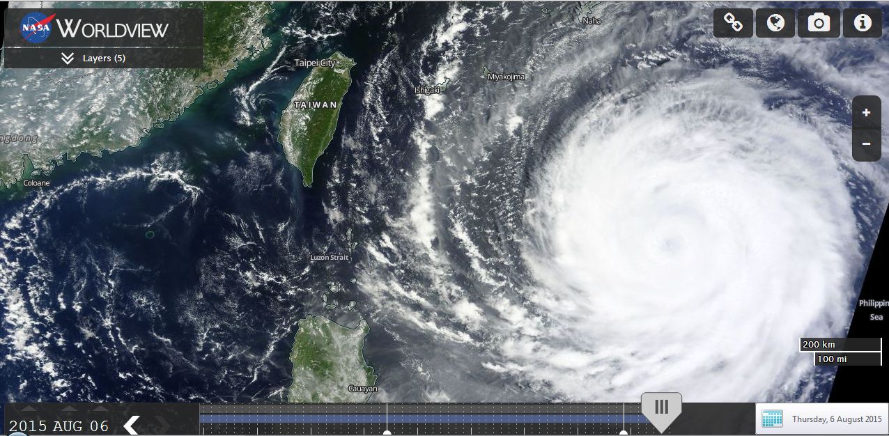
The MODIS (Moderate Resolution Imaging Spectroradiometer) Worldview image (Acquired from NASA 6/8/15) shows the typhoon approaching Taiwan which has been layered. Assuming it maintains its present course and speed, it appears that the storm would impact the island during Friday and into Saturday.
The MODIS Worldview system contains a facility to overlay population density onto a satellite image which is provided as Image Three. Assuming the storm maintains its path, it would be seen that the storm is headed for a region that contains a significant population (Both Taiwan and China). As shown:-
1 - Yellow (Lightest colour) represents a population density of 1 to 5 people per sq km.
2 - Dark Brown (Darkest colour) represents a population density of 250 people per sq km or more.
For Taiwan, Taipei is the major centre on the north side while Kao-Hsiung is the major urban centre at the south west side. There are sizeable cities between these including Feng yuan, T'ai Chung and Chang Hua.
There are still urban centres on the east coast such as Hua-lien and T'ai-tung but the population density does not compare to that of the west coast.
Should the storm maintain its present path as suggested by CIMSS (Image 2), it would hit the east coast as an intense storm then the narrow mountain range that traverses north to south across the island which would help to weaken the storm. This would probably create intense rainfall on the east coast. The storm would then pass between the major urban centres of Taipei and Kao-Hsiung. However the storm would pass over or near the urban centres of Chang Hua and Chia and others (Assuming the storm does not alter its path).
Certainly some very significant rain would occur on the east coast compared to the west coast.
The storm would pass back out to sea on the west coast being the Taiwan Strait as a weakening storm (Category 1) then make landfall on China and weaken into a rain depression.
Its going to be an interesting 2 days to see how the storm ends. Notwithstanding the details above, it is becoming more likely that the storm would pass over Taiwan unless the storm veers more north westerly that would change its current direction.