
As at mid afternoon Monday 28 September, Typhoon Dujuan is commencing landfall along the east coast of Taiwan being the same area hit hard by Typhoon Soudelor early August. The storm is coming ashore as a Category 4 typhoon on the Saffir Simpson Scale with winds calculated at 120 knots (Approximately 222 km/h) BY CIMSS.
The Central Weather Bureau of Taiwan has issued wind alerts with wind speeds of 51 metres per second with higher gusts to 61 metres per second.
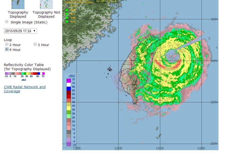
The eye of the storm is now starting to make landfall and the typhoon is moving west north west at 18 km/h.
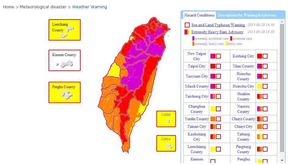
Several alerts and warnings are now in force especially across the east coast and mountainous areas.
Some of those alerts are specific for rain, flooding and probable flash flooding. Extremely Heavy Rain advisories are in force for some areas including but not limited to:-
Tagyuan City (Mountainous area).
New Taipei City (Mountainous area).
Yilan County.
Torrential rain advisories cover much of the northern part of the country and mountainous areas not covered by the Extremely Heavy Rain advisory. The typhoon is already producing some very heavy flooding rains including:-
Yilan County Datong Township 293 mm.
New Taipei City (Wulai District) 285.5 mm.
Taipei City (Beitau District) 244.5 mm.
Tagyuan City (Fuxing District) 240 mm.
being the highest figures for the 24 hour period from 2.10 pm 27/9/15 to 2.10 pm 28/9/15. It is expected that the rainfall figures quoted above and others will swell over coming hours as the storm passes over the island.
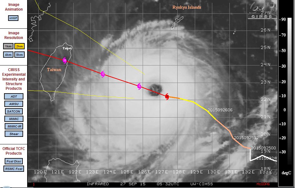
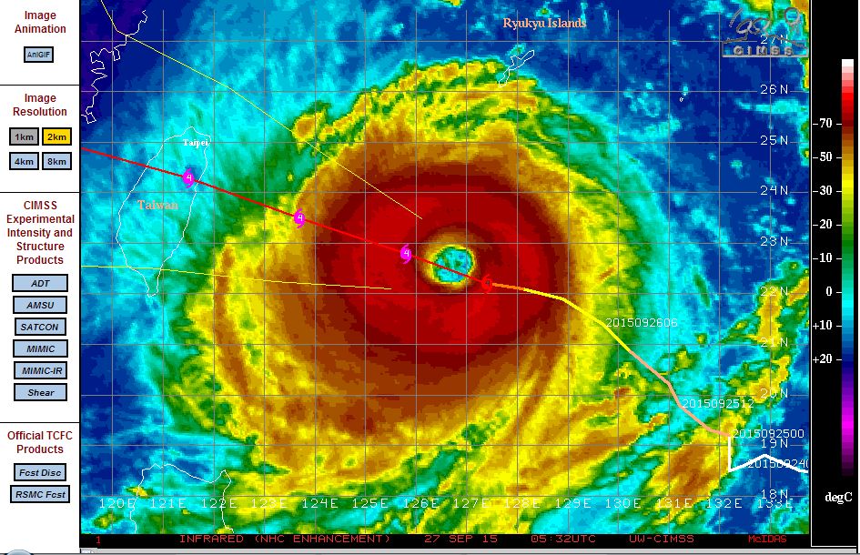
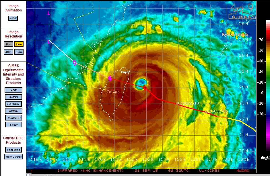
As seen in the CIMSS satellite photos and models, the storm sustains a clear eye with heavy rain bands surrounding the eye feature as it encroaches toward Taiwan. This is an intense storm capable of significant damage. It will be interesting to see the outcome given that the area would still be recovering after Typhoon Soudelor early August.
Following landfall over Taiwan, the storm will weaken significantly but will still be strong enough to make final landfall onto eastern China where it will end its life span.
CREDITS
1 – CIMSS (Various images) acquired 27 and 28 September 2015.
2 – Taiwan Central Weather Bureau (28/9/15) rainfall data, rainfall prognosis plot and radar image.
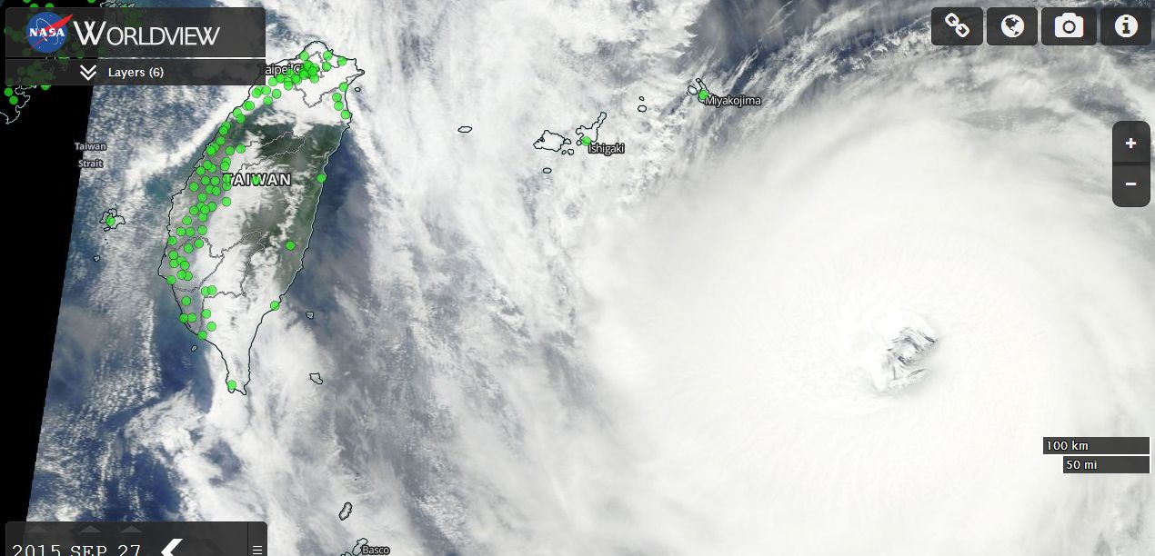
3 – NASA (Worldview MODIS) of the typhoon acquired 27/9/15.
Powerful Typhoon Dujuan has now crossed the country and the remnants of the storm has now made landfall over Fujian Provence (Peoples Republic of China). The storm has struck the same areas of Taiwan affected by Typhoon Soudelor early August compounding the recovery from that storm.
Based on news reports, there is a report of a single wind gust of 291 km/h coming from the Japanese island of Yonagunijima off the east coast of Taiwan and a wind gust of 246 km/h from Su Ao (Taiwan).
This storm was interesting because the eye collapsed rapidly just as the storm was making landfall along the rugged east coast of Taiwan. This is seen in the radar images where the eye fills in rapidly as the storm strikes a barrier which in this case is a mountain range reaching 3,997 metres in height (Yu Shan).
News reports indicate at least 7,000 fleeing the east coast cities on trains prior to train services being cancelled and more than 24,000 military personnel being mobilized to help with the disaster relief.
So far, there appears to be reports of 2 fatalities and 324 injuries as the cleanup commences.
The storm brought significant rainfall and according to the weather network and rain gauges across the country, some cumulative rainfall totals include:-
716 mm Wulai District of New Taipei City.
679 mm Wulai District of New Taipei City (Two gauges reporting).
634.5 mm Nangang District Taipei District.
625 mm Pingxi District New Taipei City.
582 mm Zhuqi Township Chiayi County.
580 mm Pingxi District New Taipei City.
521 mm Fuxing District Taoyuan City.
(Figures are cumulative for the 27, 28 and 29 covering the whole storm storm event).
Taipei has a population of around 10 million across its entire metropolitan area. Hence parts of this city has received in excess of 600 mm to 700 mm especially in areas closer to the mountains. The mountains of Taiwan has again influenced rainfall greatly. Such heavy rain creates issues of flooding, flash flooding and mudslides in such areas and similar to Typhoon Soudelor, this has occurred again.
A major cleanup is now underway including the restoration of power supplies and clearing of debris.
CREDITS
1 – Central Weather Bureau Taiwan (Rainfall data) 29/9/15.
2 – ACCUWEATHER 29/9/15 (Wind data and reporting).
3 – Dujuan Super Typhoon Thousands Evacuated from Taiwan 28/9/15.