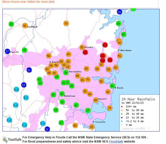
An interesting and quite significant weather event unfolded across much of Sydney during Tuesday night and early Wednesday morning. Most of the event occurred overnight and thus by daybreak Wednesday morning, the worst of the weather had passed well to the north.
Tuesday evening following a south east wind change, heavy downpours and even a thunderstorm swept across much of Sydney’s eastern suburbs. Much of the thunderstorm activity was not even noticeable from Blacktown at sunset with the storm cells hidden by low cloud and thus, no lightning was seen from where I live. If anything, most living in Sydney’s West would have been unaware of what was occurring along the coastal suburbs 20 to 30 km to the east.
Generally, no significant weather occurred other than a passing drizzle shower at sunset that brought little rainfall.
Well after sunset, a few very light showers occurred over Blacktown and Doonside between 8 pm and 10 pm.
However, between 12 midnight and 1.30 am Wednesday morning, a torrential downpour passed over much of Western Sydney including Parramatta and Blacktown producing some significant rainfall within a very short period of time. By 2 am, the event was over.
This event however short and sharp produced rainfalls of between 60 and 70 mm across Blacktown.
The evening and overnight events brought rainfalls of up to 91 mm across south eastern Sydney.
Rainfall topped 127 mm across parts of north east Sydney.
Far south west Sydney including Campbelltown, Camden and Luddenham completed missed the event and thus rainfall remained as low at 2 mm within these areas.
This event would have brought localized flash flooding and evidence of this was seen during my trip to work Wednesday morning. The heaviest rainfalls are:
- Mona Vale and Hornsby region - 102 mm to 127 mm.
- South east Sydney including the airport - 66 mm to 91 mm.
- Lower North Shore - 53 to 69 mm.
- Blacktown - 52 to 66 mm.
- Bankstown - 30 - 42 mm.
- Outer south west regions 2 mm.
By morning, the heaviest rainfall had pushed well to the north of Sydney into the Hunter Valley where large rainfall totals occurred including:
- Cessnock - 63.6 mm plus another 39.8 mm after 9 am Wednesday.
- Mangrove Mountain - 83.6 to 9 am Wednesday morning.
- Maitland - 92.8 mm for the 24 hours to 9 am Thursday morning.
Interestingly and as a result of this, the amount of rainfall for Sydney Observatory Hill for 2023 for January and February to Saturday 25 February now stands at 365.6 mm across 30 days. During the same period for 2022, 437.2 mm of rainfall had fallen. While slightly less than that for 2022 (Same period), the amounts are still high which is showing the lingering effects of the La Nina episode.

There are no photos available as the event across Western Sydney occurred during the early hours of Wednesday morning with the feature image attached taken during a torrential downpour of 2022.
