 The models are indicating a possibly active period coming up perhaps as early as Saturday. Both models seem to point to increase moisture feeding into a surface trough. An upper trough will assist in uplift to produce storms - some may be severe. Lets hope it comes off.
17 thought on “Storms on the horizon 27th October to 2nd November 2012”
Leave a Reply
You must be logged in to post a comment.
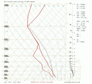
Storms on the horizon possible
Not reading too much into it yet, but the current GFS (18z) depicts a classic scenario for widespread severe storms on the 31st. Heck I'd even say tornadic supercells, but these things invariably go pear-shaped hehe.
Dave Croan suggested:
"Not reading too much into it yet, but the current GFS (18z) depicts a classic scenario for widespread severe storms on the 31st. Heck I'd even say tornadic supercells, but these things invariably go pear-shaped hehe."
The latest models have almost dropped that scenario you suggested! It seems more like a cloud band and rain with some very strong shear! Anyway, who knows what the final solutions from the varying models tend towards.
Noooooooooo…… I could enjoy storm chasing on the way to Brisbane…
The 31st has already caught me eye too..but as you say way too early
Its been very quiet to date. I have noticed the models for the 31 but early forecasts for the period do not look favourable for storms anywhere around Sydney or nearby regions. There seems to be lack of moisture. Even last Sunday when a possible storm was forecast for Sydney, I noted the low dew points and moisture. It would be nice to get that first big storm for the season. I am watching very closely to see what happens.
There still is hope for some activity with the systems in NSW and Queensland based on the current models. Most importantly, the moisture is beginning to head inland particularly in Queensland though NSW for some reason it seems to be limited somewhat inland at least. I nice trough is developing in Queensland exntending into NSW over the period. A nice cold pool seems to pass across the state from western Qld and NSW. I hope this cold pool does not stall.
I have seen early models especially for November 2 although they could change. I have allocated my flexi day off work next Friday so if the models are as good as suggested, then this could be my first real storm chase of the season. Only reviewing Weatherzone at this stage but still early. The BOM has revised its ENSO outlook for the season and El Nino is unlikely to occur. It is suggested the pattern will return more towards Neutral through November and the IOD (Indian Ocean Dipole) should tend back to neutral as well allowing for a return to more neutral summer conditions. This could be the start of the summer storms.
Mind you that cursed EC model is not having a bar of it, building yet another strong anticyclone in the southern ocean with a cold front clipping SE Australia. Trouble is EC has hit the money on the last few events, albeit snow ones
Look how desperate we all are talking about an event so avidly this far in advance :) GFS certainly toying with the event.. 00z run showed almost a TOR setup, 06z run not so excited, and the run before that showed nothing. I have not been too upset about the lack of stormage due to thesis writing.. however that is due on Monday and from then it can storm all it wants :)
I do believe that at least a couple of days will come into being over the next week or so. Harley Pearman has also picked up on another possible event albeit dreamland! Hopefully not a rain event. I am also interested in the event this Sunday despite slightly unfavourable shear.
Michael Thompson lets hope EC is not on the money:) But there is consistency of EC with the Bureau of Metoerology model for the latter event.
As long as we see moisture return next Wednesday and Thursday is looking interesting. I'm down in Victoria working tuesday and it turns out I'll be coming home wednesday so if it pans out I'll be taking the Olympic Hwy inland for some awesome storm chasing (hopefully)!
As one would have expected, the models have played down the current anticipated storm events. There still should be storms and some severe but not the potent setups we were expecting at the start of this post!
Yeah, we've had a bit of rain too!
Da-Gio, Where do you live that you already have had some rain!
A line of slow moving thunderstorms moved mainly through the western and northern parts of the greater Brisbane region. No warnings for any of that activity. The freshening SE winds helped kick up the storms though also prevented them becoming severe. I had expected one or two to become stronger in the Esk region, and while there were some decent features reported it didn’t quite get there.
Meanwhile to the south we enjoyed a day of stratocumulus and altocumulus – thrilling !