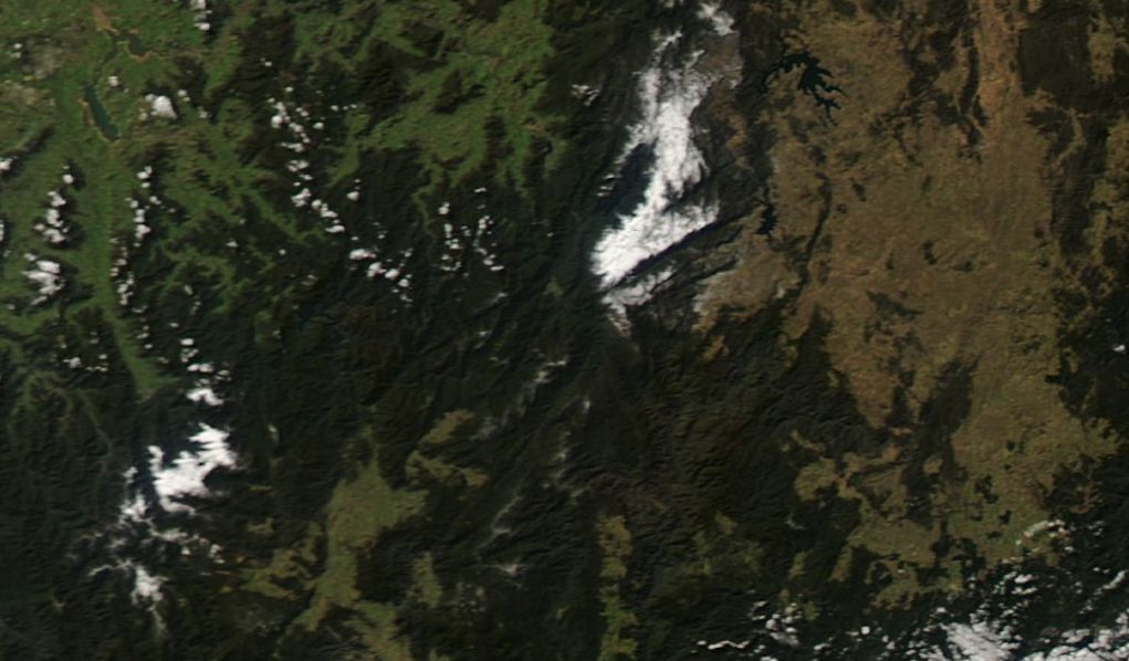
A satellite photo of South East Australia taken Wednesday 3 June 2015 (RAPID LANCE MODIS sets) shows snow covering the Snowy Mountains and the higher peaks of North East Victoria including Mt Bogong, Mt Feathertop, Bogong High Plains and Mt Hotham. Looking at this photo image, it can be seen that snow has fallen to areas around Jindabyne to the east of the Snowy Mountains.
The event occurred during Sunday and Monday 31 May and 1 June as a strong cold front passed through which resulted in snow falling to as low as 600 metres in elevation across parts of Victoria and including areas east of Melbourne.
News reports suggests 20 to 30 cm of snow falling at higher elevations.
In the wake of the cold front and with clear skies overnight, minimum temperatures have been dropping well below zero across many towns and regions away from the coast leading to frost outbreaks during the mornings. The coldest minimums have been occurring on the tablelands and ranges which include:-
Bathurst - Minus 4.5C recorded on the morning of the 2/6/2015 and minus 4.8C recorded on the morning of the 3/6/2015.
Corryong (NE Victoria) - Minus 4.1C recorded on the morning of the 3/6/2015.
Glen Innes - Minus 5C recorded on the morning of the 2/6/2015.
Goulburn - Minus 3.5C recorded on the morning of the 3/6/2015.
Orange - Minus 4.7C recorded on the morning of the 3/6/2015.
These are some examples. Canberra has recorded a minimum of minus 7C on the morning of the 2/6/2015 and minus 5.1C on the morning of the 3/6/2015.
These are cold mornings although this is leading to clear crisp sunny early winter days.
Similar minimum overnight temperatures are being forecast for the night 3/4 June including a forecast of minus 5C for Canberra, minus 4C for Glen Innes and minus 3C for Bathurst.
In addition to this, a few cold daytime maximum temperatures have also occurred including a maximum of 6.8C at Orange for the 2/6/2015 and 5C for Oberon on the 1/6/2015.
Another cold front will be crossing through Victoria on Thursday and Friday which will provide some additional snow to higher elevations while ending the current spell of very cold nights for some localities.
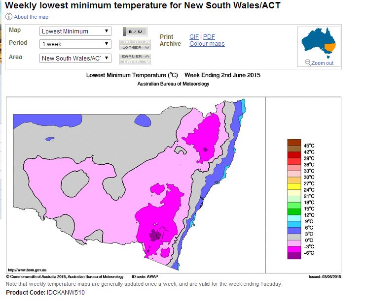
The minimum temperature plot for the week ending 2 June 2015 for New South Wales is attached showing the areas that has experienced the very cold temperatures.
Wow Harley! Amazing satellite images of the snow and charts!
Wow Harley! Amazing satellite images of the snow and charts!
The morning of 4 June 2015 saw further cold morning temperatures across some parts of south east Australia continuing the cold spell especially during the mornings. The following morning temperatures occurred:-
Canberra – A minimum of minus 6.4C occurred at 6.30 am and the temperature was still minus 0.3C at 9.15 am. Despite this, the maximum temperature reached 10.7C at 2.30 pm giving a range of 17.1C for the day between the minimum and maximum. At night with no cloud cover, the heat gained during the day is rapidly lost. Interestingly on Mt Ginini at over 1,700 metres in elevation, the minimum temperature reached was minus 3.2C at 3.30 am.
Cold air being more dense sinks and can pond in low lying areas and as a result, it can be colder in valleys under certain conditions than at higher elevations.
Cooma had a low of minus 7.4C at 6.30 am and minus 7.3C at 3.30 am. This came with dew points as low as minus 8.2C.
Goulburn had a low of minus 7.2C at 6 am being another cold location.
Bathurst had a low of minus 3.5C at 7.30 am.
Orange at 880 metres in elevation had a low of minus 4.3C at 7 am which came with a dew point of minus 5.4C.
Thredbo Top Station
The coldest location that can be found during this cold spell is minus 9C at Thredbo Top Station recorded at 1.30 am on the 3/6/2015 which came with dew points of minus 10.5C.
The attached plot for 3 June 2015 (New South Wales) is now available for “Mean minimum temperature” which is showing that the coldest locations with minimum mean temperatures were the ranges and tablelands although the Snowy Mountains were by far the coldest.
There is a cold front crossing Victoria and Southern New South Wales which is bringing showers, highland snow and wind. It would be expected that the very cold temperatures would contract to the higher elevations of the Snowy Mountains and NE Victoria as expected at this time of year during the passage of this cold front.