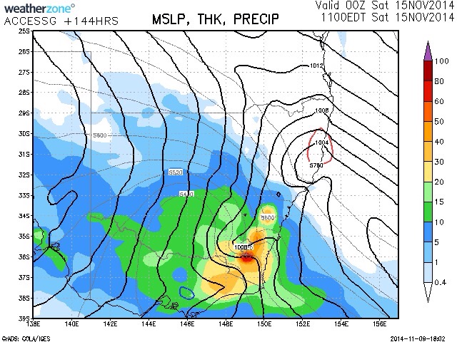
Both the Bureau and GFS models are in agreement for some useful falls of rain and a cold air mass entering the state by next weekend. Rainfall totals of the order of 60 to 80mm may be expected in some locations in extreme eastern Victoria and South - East New South Wales by Saturday morning. This system is exited to be preceded by a hot airmass with gusty North westerly winds affecting air from central Australia.
Once the system moves through, temperatures will drop rapidly. Meanwhile, it is more than likely that flooding may occur in the regions affected particularly the low lying regions. One to watch at this point.
Rain is needed in many parts of the country where lower than average precipitation has been recorded so far this spring and in some cases for longer. It seems possible that more follow up rain in the following week may also be on the cards.
Update: Models have downgraded this event with only the chance of precipitation Saturday night into Sunday as a not so vigorous system passes through.
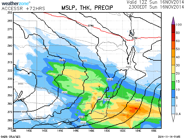
Now the models have again come through with significant rainfall across SE Australia during Sunday. This is anticipated as an upper trough rapidly moves across the state. Widespread falls of 20 to 30mm is expected across southern NSW and eastern Victoria.
Check out the rainfall progs for next weekend!
A rainfall event did unfold across North East Victoria and the southern inland of New South Wales from this system. The system also affected the southern part of the Central West slopes, eastern Riverina and the Snowy Mountains of New South Wales.
Rainfall was not as heavy as expected but the falls were useful considering that it has been dry.
I have looked at the rainfall totals from this event and the best falls are described as isolated in nature.
Mt Wombat in North East Victoria had the best fall of 63 mm.
In southern New South Wales, the following totals are evident:-
Thredbo 55 mm.
Geehi Airstrip 53 mm.
Tumut 52 mm.
Upper Gooborrogandra 50 mm.
Followed by:-
Hunters Hill 39 mm.
Tooma Dam 37 mm.
Khancoban 35 mm.
Anywhere east of the Hume Reservoir to the Snowy Mountains received from 25 mm to 49 mm being the hilly rugged area.
The eastern Riverina region received from 10 to 24 mm including:-
Albury Airport 24.4 mm.
Wagga Wagga 22 mm.
Lighter falls occur further west.
Much of North East Victoria received from 25 to 40 mm with Seymour receiving 50 mm.
Further east of the Snowy Mountains, rain shadows dominated.
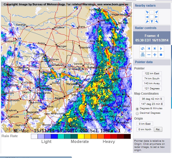
I have attached the radar image of early Sunday showing the main rain band passing through southern New South Wales. This system did produce isolated lightning flashes but no significant thunderstorm activity. This system had largely cleared early Sunday morning.