For the period 29 to the 31 January 2023, a number of significant rain and storm events impacted parts of New South Wales and portions of North East Victoria adjacent to the Murray River.
I was unable to chase Sunday afternoon due to work related commitments but I did manage to watch the thunderstorm event that unfolded across the outer northern areas of Sydney from the top of Rooty Hill.

Prior to 1.30 pm Sunday, much of the day was characterized as being a sultry. It was partly cloudy with temperatures reaching into the low 30s throughout much of Western Sydney. It was also humid. The development of cloud and thunderstorms with one cell to the south east of Sydney and a more significant cell to the outer North West of Sydney represented a cool change.
A significant thunderstorm passed across outer North West and northern Sydney delivering high rainfall. This was a slow moving storm cell and distant cloud to ground lightning was observed.
At Mangrove Mountain, rainfall topped 60.2 mm from the event.
Late thunderstorms also occurred into the Hunter Valley.
Significant rainfall southern New South Wales
However, while this event was occurring, an unexpected rainfall event occurred along the New South Wales / Victorian state border which was not in the forecast notes and not expected by weather models. During Sunday and into Monday morning, a local convergence zone stretching from Rutherglen, through Albury / Wodonga and east south east towards the Great Dividing Range resulted in high rainfall totals and local flooding. From this event:
- Rutherglen - 94.6 mm.
- Albury Airport - 132 mm (This was the wettest day for Albury since 1 April 1863 when 167 mm fell). Another 4.8 mm fell between 9 am and 11 am.
- Hume Dam - 134 mm.
- Beringama - 145 mm.
- Hunters Hill - 150 mm.
(All figures to 9 am Monday morning.)


The rain was having a “Train echo effect” and passing over the same area for many hours before the effect finally broke down Monday morning.

Places on either side and only 20 km away only received 20 mm. As indicated by a report in Weatherzone, such events are hard to predict as they are often localized to a very small narrow area. This event did lead to local flooding across affected areas.
Monday afternoon storm - Western Sydney
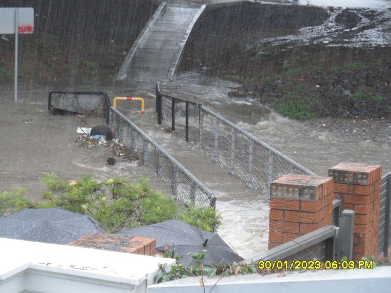
After another humid day across Sydney, a strong afternoon thunderstorm occurred across much of Western Sydney. A slow moving thunderstorm cell that was severe warned for heavy rain made slow progress across parts of the city. This had a major impact on the afternoon peak hour traffic and I witnessed significant flooding on the M4 Motorway near the Woodville Road on ramp where floodwaters were deep enough for a small car to float. The outside lane was impassible due to floodwaters.

Numerous roads around Auburn, Clyde, Granville and Parramatta were difficult to drive on due to the high intensity storm and flooding.
The photos attached taken by a work colleague shows the creek underneath the M4 Motorway close to Woodville Road being flooded in a very short time. Falls of 50 to 60 mm were common within this area.
Sydney City experienced 63 mm which contributed to 191.4 mm for the month of January which is a wetter start to 2023 than at the same period for 2022.
Given what occurred, this was certainly a dynamic period weather wise. The dynamic weather continued throughout the week ending Friday 3 February which saw a strong cold front pass across southern Australia. The event produced snowfalls to the higher elevations of New South Wales and Victoria and a significant thunderstorm and microburst event at Port Macquarie that caused significant damage across town Friday afternoon.

The photos of the storm were all taken at Rooty Hill but the photos of the flooded creek at Granville / Merrylands were taken by a work colleague - Sam Mitry with permission for use in this report.