

Barely 2 weeks after a major weather event impacted much of Australia’s east coast that brought flooding, 5 fatalities and a damage bill that appears to have topped $238 million to date, another event is expected to unfold across the same regions during Sunday and into Monday.
However this event is not expected to be as severe as the first one. A low pressure cell is expected to develop across inland Queensland and track south east and cross the coast to form another east coast low. The low may cross the coast south of Sydney during Sunday.
A large mass of rain bearing cloud has developed across inland Queensland around and to the west and south of Mt Isa which should track south east with the developing system.
Extensive rainfall is expected across much of eastern and northern New South Wales but not to the same intensity of what occurred on the 5 and 6 June.
It is becoming clear that the western and south western areas of New South Wales should miss the event altogether.
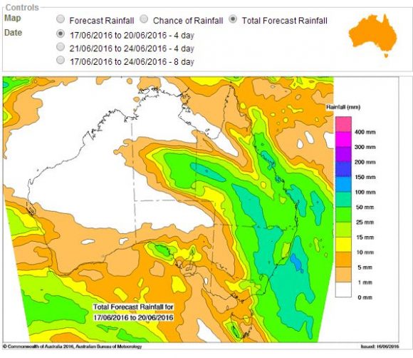
The Water and the Land model from the Bureau of Meteorology is suggesting a substantial region of New South Wales and Queensland to receive at least 25 to 50 mm with higher falls of 50 to 100 mm across some regions.
The rainfall model from Weatherzone identifies a large region of New South Wales to receive at least 60 to 90 mm from the event which extends into North East and Eastern Victoria. The same model would suggest falls of up to 120 mm to 150 mm for limited regions of inland Queensland.
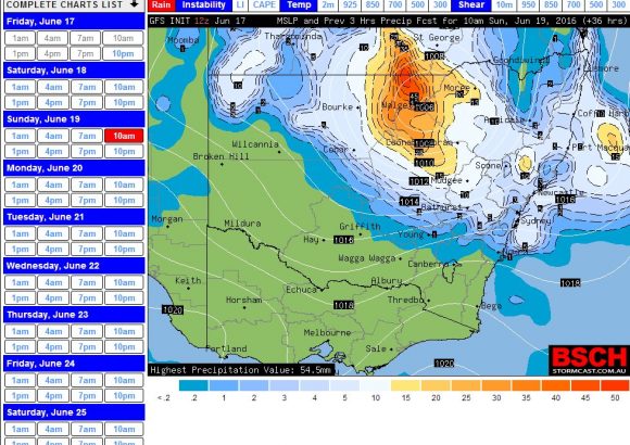
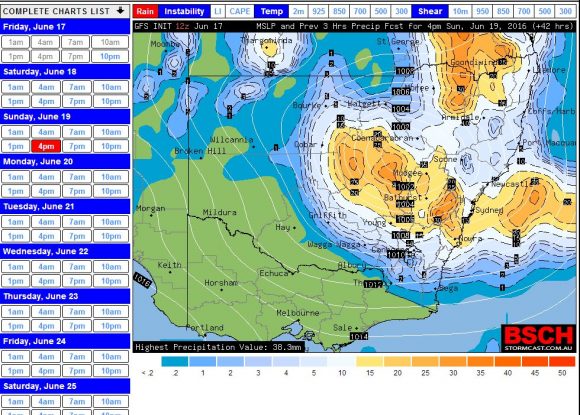
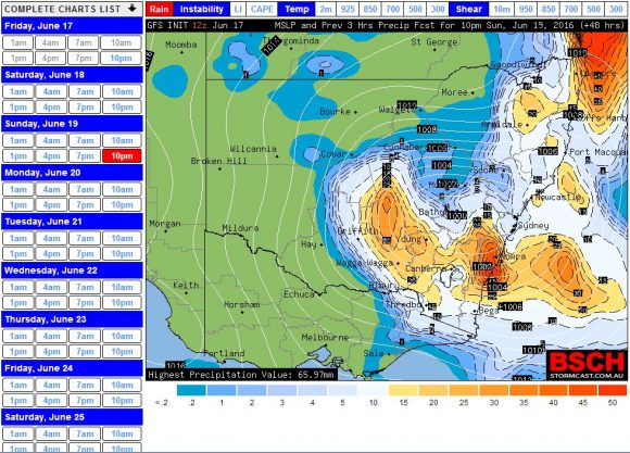
Models from BSCH indicate some heavy rain moving south east through New South Wales during Sunday to reach Sydney during Sunday afternoon and the South Coast into the latter part of the afternoon and evening.
There are weather warnings in place for minor to moderate flooding in several river systems including Tweed Valley, Richmond and Wilson River valleys, Bellinger, Nepean and Hawkesbury, Gwyder and Castlereagh Rivers.
There are also gale warnings for the Byron coast, Coffs Harbour, Macquarie Coast and Hunter Coast with strong wind warnings for coastal areas further south such as Sydney and the Illawarra.
There are also flood watches for certain rivers in North East Victoria being the Upper Murray, Mitta Mitta, Kiewa, Ovens and King Rivers but this would depend on the position of the low and how much rainfall occurs.
Flood watches also exist for certain rivers across East Gippsland such as the Cann, Mitchell, Tambo, and Snowy Rivers.
In Queensland, flood watches are in place for areas where rainfall figures are forecast to reach 50 to 80 mm such as the Georgina, Diamantina, Coopers Creek and Paroo River.
The weather system is expected to move relatively quickly through south east Australia.
Overnight 18/6/2016, some areas of inland New South Wales received some useful rainfall totals unrelated to the event described above. Orange received up to 36 mm and areas around Dubbo to Orange had falls of 25 to 37 mm being the highest falls across New South Wales to 9 am 18/6/2016.
For the 24 hours to 9 am 19/6/2016 moderate to heavy rain engulfed regions of inland Queensland. The heaviest falls were within the Longreach, Charleville and Blackalll regions being areas that have been suffering from drought. Rainfall topped 119 mm at Warsey Downs followed by 111 mm at Wahroongha and 109 mm at Mt Harden Alert.
Much of the Charleville area consisting of grazing properties had between 80 and 97 mm of rain for the period.
The extensive falls extended south into a portion of Northern inland New South Wales where Lightning Ridge had 61 mm, Goodooga had 56 mm and Angledool had 54 mm.
The rain has since reached the coast and has now settled into Sydney for the afternoon.
The satellite image of eastern Australia during Sunday 19 June from NASA’S MODIS satellite is showing an extensive cloud mass across Eastern Australia. Fortunately the weather system created less issues than the previous system and it moved through fairly quickly.
Heavy rain fell across Brisbane and portions of South East Queensland as shown in the attached rainfall plot for Brisbane. A narrow north to south path path is visible where significant falls occurred. Within this path, Warners Alert received 199 mm, Toowong Alert received 177 mm and Browns Creek Road Alert received 173 mm all to 9 am 20/6/2016. This would have caused flooding issues across low lying areas.
Within New South Wales, rainfall was not as significant as the previous event but there were still a few sizeable falls to 9 am 20/6/2016. Mullumbimby received 123 mm followed by 122 mm at Wilson’s Peak Alert (Right on the NSW / QLD state border).
Many centres along the coastal fringe received between 50 and 100 mm including 87 mm at Lowanna (NW of Coffs Harbour) and 71 mm at Currarang (South Coast).
Across Sydney, a period of heavy rain occurred but due to the rapid movement of the weather system, rainfall totals did not approach anywhere near the falls that occurred 2 weeks ago. Other than a few minor issues, no significant impact occurred. Rainfall across Sydney ranged from 12 mm to 62 mm with many weather stations receiving 20 to 40 mm. The highest total was 62 mm at Castle Cove.
Based on news storeys, there were at least 500 SES call outs across New South Wales mainly for leaking roofs and minor flooding within a few low lying areas but generally this event was no where near as severe as the previous system.