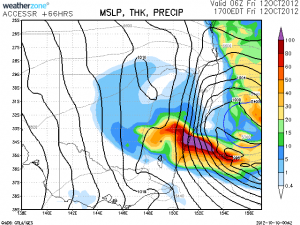
Is this the first serious rain event for October in Sydney for some years - wow! If this occurs, flash flooding will result! There will be areas in Sydney depicted to have in excess of 100mm of rain. I like this type of parttern!

21 thought on “Rain Event 11th -12th October 2012”
Leave a Reply
You must be logged in to post a comment.
100mm of rain for Sydney? Wow!
I'm interested to see which model gets this system right, there is a big variation between ACCESSR and GFS over the position of the low and subsequent rainfall.
Its interesting to see the variation in the models. The Weatherzone model really does show a rain event for Sydney. Yet the GFS suggests 10 to 25 mm for Sydney and an area south of Wollongong to Bega getting the heaviest falls. One BOM rain model suggests 50 to 100 mm for Sydney but another on Water and the Land suggests a 50% chance of 15 to 25 mm (Friday) especially for the southern suburbs and south coast. The variation is evident.
It seems the Bureau is already prompting for the Illawarra and South Coastal regions for flooding – well a Flood Watch.
Early morning rain with 6mm at Schofields. Clearing edge so we will see if thunderstorms will eventuate later.
The sky looks unsettled consistent with developing storms aloft above the low clouds.
The satellite image is quite spectacular showing a major cloud band stretching from northern Australia to central NSW.
There are some remarkably cold surface temperatures out west with the passage of the upper low. White Cliffs has dropped momentarily to 5.4 and Wagga and West Wyalong are both under 8.
The upper level low seems to be further inland at the moment near Wagga Wagga – expected to intensify on the South Coast tonight.
A very weak storm cell has passed just south of Blacktown. One sheet lightning flash and a rumble of thunder. Although when looking at the radar a stronger cell is moving SSE over Liverpool and away from Sydney. Just prior to sunset, I noted cumulo congestus clouds south and west and a low topped cumulonimbus cloud to the south. Ulladulla on the south coast of NSW has a rainfall total of 165 mm when I looked at 8.20 pm.
100mm of rain for Sydney? Wow!
I’m interested to see which model gets this system right, there is a big variation between ACCESSR and GFS over the position of the low and subsequent rainfall.
It seems the Bureau is already prompting for the Illawarra and South Coastal regions for flooding – well a Flood Watch.
The upper level low seems to be further inland at the moment near Wagga Wagga – expected to intensify on the South Coast tonight.
Its interesting to see the variation in the models. The Weatherzone model really does show a rain event for Sydney. Yet the GFS suggests 10 to 25 mm for Sydney and an area south of Wollongong to Bega getting the heaviest falls. One BOM rain model suggests 50 to 100 mm for Sydney but another on Water and the Land suggests a 50% chance of 15 to 25 mm (Friday) especially for the southern suburbs and south coast. The variation is evident.
Early morning rain with 6mm at Schofields. Clearing edge so we will see if thunderstorms will eventuate later.
The sky looks unsettled consistent with developing storms aloft above the low clouds.
There are some remarkably cold surface temperatures out west with the passage of the upper low. White Cliffs has dropped momentarily to 5.4 and Wagga and West Wyalong are both under 8.
A very weak storm cell has passed just south of Blacktown. One sheet lightning flash and a rumble of thunder. Although when looking at the radar a stronger cell is moving SSE over Liverpool and away from Sydney. Just prior to sunset, I noted cumulo congestus clouds south and west and a low topped cumulonimbus cloud to the south. Ulladulla on the south coast of NSW has a rainfall total of 165 mm when I looked at 8.20 pm.