As shown in the attached photograph, the sky on Sunday afternoon is providing clues in relation to another approaching weather change. Usually, the presence of alto cumulus and castellatus cloud is a sign of future thunderstorm activity within a region or a major weather change. The presence of such cloud is a sign of instability in the atmosphere.

Weather models and forecasts are clearly suggesting a significant weather change across much of New South Wales for the week commencing on Monday 21 February 2022 through to Saturday 26 February 2022.
The cumulative rainfall forecasts for Sydney are now within the range of 39 mm to 90 mm for the six day period, mainly from shower activity across each day. It appears for Sydney, Monday to Wednesday will be the wettest period for the city where between 29 mm and 60 mm of rainfall is suggested.
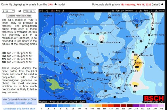
However further north of Sydney and even across the northern inland areas of New South Wales, there are forecasts being made for thunderstorm activity, especially on Monday. One model considered is showing the potential for significant rain and storm activity just to the north of Sydney including Newcastle for Monday afternoon / evening.
Rainfall models appear consistent around Sydney and the North Coast where forecasts are being made for falls within the range of 50 to 100 mm (Cumulative totals) although higher isolated falls of up to 125 mm cannot be ruled out should thunderstorms occur.
Some of this rainfall is forecast to penetrate well inland New South Wales, especially around Bourke and Walgett and areas west of Coonabarabran. When compared to January, February has been exceptionally dry to date for most of the inland. Lighter falls of 10 to 20 mm are also being made for much of the south west wheat sheep belt of New South Wales for the same forecast period.
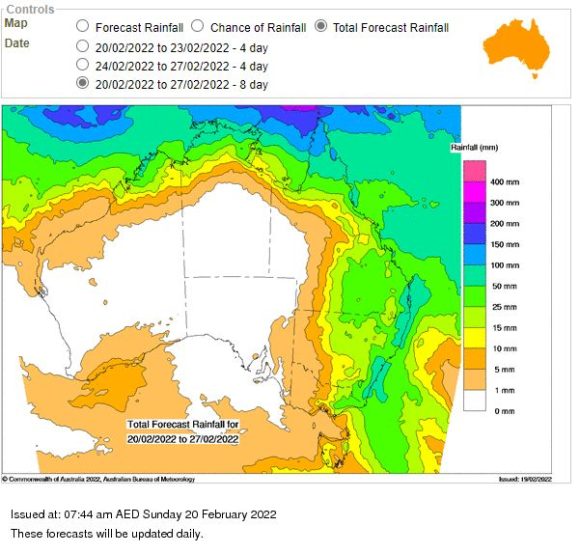
The rainfall plots shown are from the Water and the Land site and BSCH and both appear to be relatively similar in terms of where this event is expected to occur and likely cumulative rainfall totals.