Over the past week, there have been several rain / storm events across large regions of Australia which has continued a recent pattern of wet weather and flood events.
The events have impacted tropical Northern Territory where the monsoon has become active, northern Queensland, much of New South Wales and again spilling into portions of Victoria.
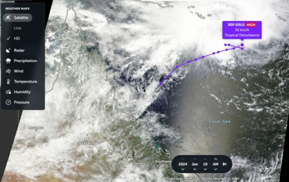
In addition to this, a new threat is now developing off the north east Queensland coast in which a tropical storm is beginning to take shape and is expected to develop into a tropical cyclone in coming days. The storm looks set to track south west and make landfall close to the regional city of Townsville. Should the event occur, it will only continue the series of storm events that has been occurring since December.
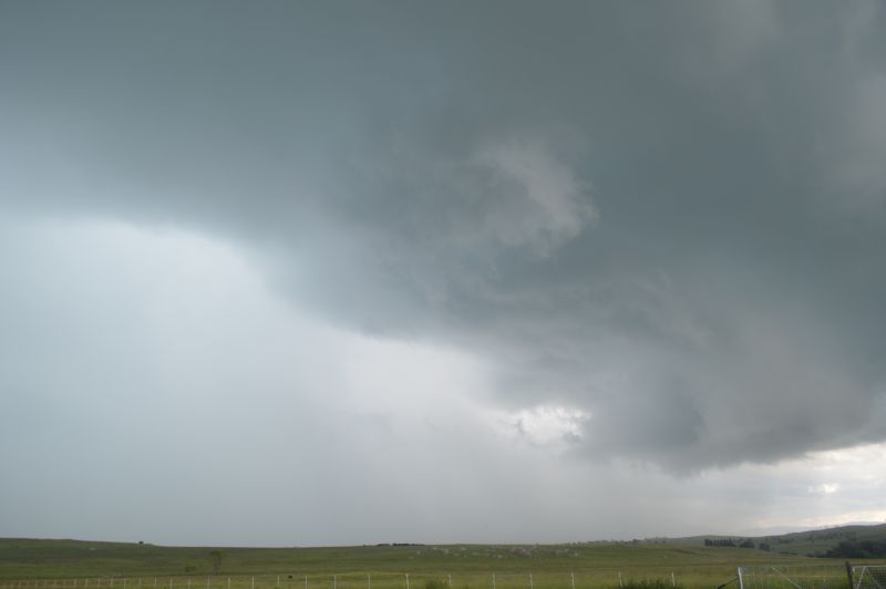
Note:- The feature image is from a recent storm chase at Braidwood New South Wales (January 2024) but provides an idea of the weather events occurring across larges areas of Australia at the present time.
The main events are described below.
Northern Monsoon becomes active (Northern Territory)
Over the past week, the northern monsoon certainly became active over the top end of Northern Territory delivering flooding rains across a wide swathe of the Top End. Almost every year, monsoon flood events characterize this part of Northern Territory. A monsoon low moved south but weakened south of Tennant Creek. The storms and associated rain events are a normal part of the weather cycle. Generally when this occurs, most rivers flood and remote communities would become isolated by flood waters.
Over the past week, the Darwin region received between 93 mm and 228 mm of rainfall. While rainfall is widespread, thunderstorms can and do deliver the heavier falls. The highest weekly cumulative rainfall to 9 am Saturday 20 January from this event includes:
- Port Keats Airport - 660 mm.
- Douglass River Research Farm - 372.6 mm.
- Central Arnhem Plateau - 365 mm.
- Bradshaw - 347.8 mm
- The Pines (Near Pine Creek) - 273 mm.
Generally falls of 100 to 300 mm were common across the Top End region and areas to the south (Base of the top end including the Katherine region.
Monsoon rains and heavy rainfall (North East Queensland)
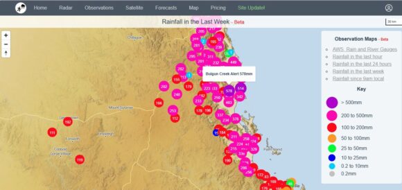
Another region to be impacted by heavy rainfall is north east Queensland around Cairns for the second time in recent weeks. Cumulative weekly rainfall (7 days to 9 am Saturday 20 January 2024) have approached 600 mm at isolated locations. Heaviest totals include:
- Bulgan Creek Alert - 578 mm.
- White Cliff Point - 515.8 mm.
- Bingil Bay - 514 mm.
- Daintree Village - 402 mm.
Cumulative totals of 100 to 300 mm have occurred around the city of Cairns.
New South Wales / Queensland Border (Plus Tweed Valley New South Wales)
This region has experienced a wet summer and again the past week has been no exception. Cumulative rainfall totals (7 days to 9am Saturday 20 January 2024) have generally approached 300 mm across the Tweed Valley including:
- Coolangatta / Tweed Heads - 347 mm (State Border).
- Uki (Tweed River) - 279 mm.
- Bray Park Water Treatment Plant - 272 mm.
Falls of 200 mm or greater have been common across the Tweed Valley.
North of Brisbane, the Sunshine Coast experienced cumulative falls of 100 to 241 mm.
Bellingen Valley (New South Wales)
Some very heavy rainfall totals have occurred especially during Monday and Tuesday 15 and 16 January in which daily totals approached 300 mm. This included 277 mm at Dorrigo Mountain, 269 mm at Bellingen and 257 mm at Thora Post Office. This was enough to cause flooding along the Bellinger River.
Cumulative weekly totals to 9 am Saturday 20 January 2024 are significant including:
- Lowanna - 431 mm.
- Dorrigo Mountain - 372 mm.
- Dorrigi - 341 mm.
- Bellingen Crystal Creek - 336 mm.
The 200 to 400 mm falls were mainly limited to the Bellinger Valley and amongst the hills west of Coffs Harbour City.
Sydney (New South Wales) Sunday and Monday
Further south, Sydney experienced a wet Sunday evening which extended into Monday with some heavy rainfall. Daily rainfall totals topped 100 mm at isolated areas around Parramatta by 9 am Monday 15 January 2024 including:
- North Rocks - 122 mm.
- North Parramatta - 104 mm.
- Baulkham Hills - 101 mm.
A fall of 136 mm occurred at Kurrajong Heights being the highest total.
Cumulative weekly totals across Sydney for the 7 day period ending Saturday 20 January 2024 are significant including:
- North Rocks (Muirfield Golf Club) - 206.5 mm.
- Northmead Bowling Club - 171.5 mm.
- Parramatta North (Masons Drive) - 170.6 mm.
- West Pennant Hills - 151 mm.
- Kings Langley - 145.5 mm.
- Shanes Park - 141 mm.
Generally, the 100 mm plus totals were limited to a narrow path approximately 20 km wide starting west of the Sydney Central Business District then north west to Richmond. Suburbs on either side of the path received much lower totals dropping to just 27 mm at Erskine Park and 29 mm at Fairfield City Farm.
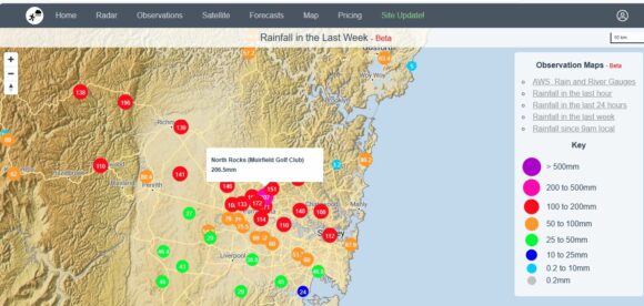
Of interest, I have a rain gauge and the cumulative totals from this have been tallied to 110 mm across the past seven days which appears to be consistent with the official rain gauges nearby.
Canberra (Australian Capital Territory)
Thunderstorm activity on the afternoon of Saturday 13 January produced significant rainfall totals of up to 71 mm at Lake Burley Griffin with 50 to 70 mm being common across other parts of the city.
Interestingly, cumulative weekly totals to 9 am Saturday reveals falls of 96.8 mm at Tuggeranong and 81.4 mm at North Canberra (Sullivan Creek). This is significant for Canberra as such high totals are generally rare.
North East Victoria (The high country)
Not as dramatic as elsewhere, but cumulative totals have topped 50 to 60 mm across the north east parts of Victoria but limited to the high country with most of this occurring on Tuesday / Wednesday.
Expected tropical cyclone (Not officially named at the time of writing)
Notwithstanding the above recent events, weather models are now identifying a new storm system to form off the Queensland coast which will only add to the storm events that have impacted Queensland since December 2023. Weather models appear to suggest that the storm will develop into a tropical cyclone and track south west towards the Queensland coast close to the city of Townsville late in the forecast period.
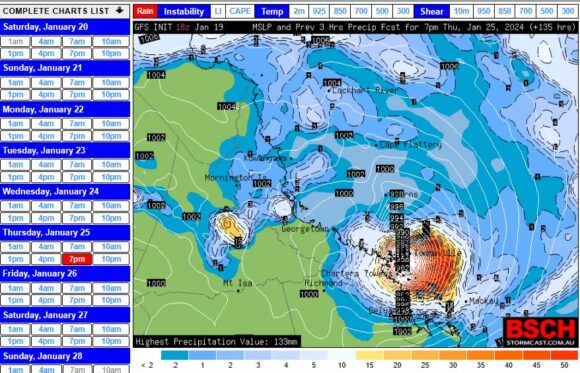
At the present time, it would appear that the area between Townsville (North) and Mackay (South) is most at risk although the BSCH model for late Thursday 25 January as shown would suggest that any landfall would be closer to Townsville rather than Mackay.
The impact of this storm would be substantial in terms of flooding, gales and storm surges and if it tracks directly over a built up area, the impact would be substantial.
CIMSS models now has the storm shown as “Investigation” and waters off the coast are at 30C providing a favourable environment for its development. The storm will be covered in separate future statements should the system develop as expected.
I have also attached a satellite image of the storm (Zoom Earth NASA) showing the storm in its early phases of development north east of the Queensland coast which is the area to watch in coming days.
