During the period of 9 to 14 January 2015 at least two major rainfall events unfolded across a significant portion of South Eastern Australia. In general this event swept south east during the period which has resulted in a number of weather phenomena being recorded.
This event has had many positives but also some negatives including:-
- The bush fire crises was eased in Victoria and South Australia.
- A flash flood or flood event occurred at Bendigo following a single rain event.
- Many areas have exceeded their normal January average rainfall.
As part of this system that swept through on Friday 9/1/2015, thunderstorms developed across parts of Western Sydney producing an isolated fall of 66 mm at Blacktown Dog Pound. This storm also affected power supplies across the Blacktown area.
On Saturday evening, a heavy rainstorm again swept through parts of Sydney producing another 30 mm deluge over Blacktown.
Thunderstorms and heavy rain events during the period boosted rainfall totals in some areas such as 167 mm at Fowlers Gap in far Western New South Wales (This is a cumulative figure for the week ending 12/1/2015). Other strong readings of 149.2 mm was recorded at Berridale and 117.6 mm at Tumbarumba Post Office.
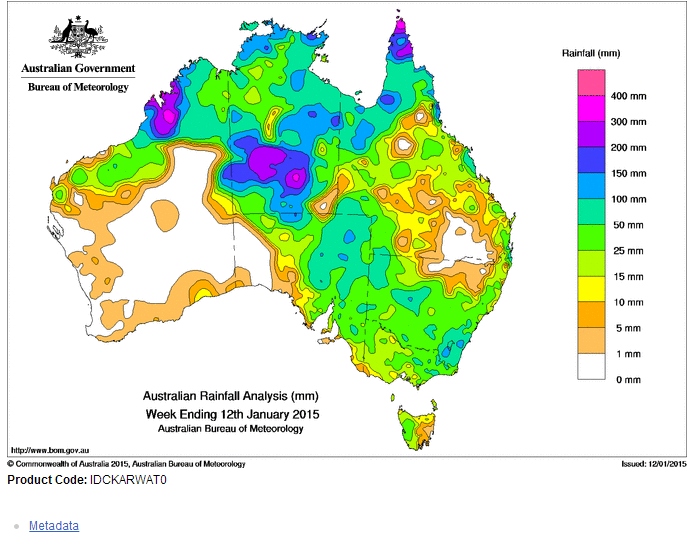
For the week ending 12/1/2015, the most significant rainfall fell in an area near and west of Alice Springs of Central Australia. In this regard, rainfall totals exceeded 200 mm and approached 300 mm for the region. Another area in North West Western Australia also received similar but substantial totals.
Rainfall covered most of New South Wales except the northern inland in areas such as Narrabri and Moree. In South East Australia and primarily in New South Wales, an area south and east of Canberra received cumulative totals of between 50 and 100 mm and smaller areas received higher cumulative total of 100 to 150 mm.
In western New South Wales, large areas received falls of 50 to 100 mm.
Even in Victoria, good falls have occurred across large areas of the state.
It is also identified that an area around Hobart in South East Tasmania received a drenching during the latter part of the period including 153 mm at Mt Wellington.
I have produced a number of plots and tables demonstrating where rainfalls occurred. I have produced individual tables for a number of events which builds an overview of which region received what, especially across New South Wales. I also include the Southern New South Wales event of the afternoon of the 13/1/2015 and the South East Tasmania event around Hobart.
I attached the plots showing the rainfall across Australia during the period. This is a cumulative plot for the week ending 12/1/2015.
The plots taken from the Bureau of Meteorology ‘Water and the Land” shows how widespread the event was.
I also attach the plot for the Murray Darling Basin region. I have done this to show that large swathes of the region received healthy totals which is unusual for this time of the year. Normally the summer period is rather dry but this event is significant for this region due to the widespread nature of the event.
I attach tables showing rainfall across regional New South Wales. The tables show the highest figures for the various regions. These are cumulative totals ending the week 12/1/2015.
I also attach a table showing the Southern New South Wales and North East Victoria event which concluded on the 14/1/2015.
The rainfall plot for Victoria for the 14/1/2015 shows two regions receiving strong totals being North East Victoria and a region south west of Geelong. The second table presented above reflects what the plot is showing.
During the latter part of the period, South East Tasmania received a drenching. I attach the final plot for the post being that for South East Tasmania and including Hobart. The heaviest totals include the following:-
Mt Wellington – 153 mm.
Leslie Vale – 147 mm.
Anywhere along the east coast of the island state had solid totals of 54 to 96 mm depending on location. It is interesting to see how the heaviest totals align with the coast.
This event appears to be the last to affect the country and it appears that more settled conditions will develop over the south east for the foreseeable period.
The rainfall event in and around Hobart 13 and 14 January 2015 was found to be more significant than first realized. A summary of the event is provided here which is taken from a report from ‘Weatherzone” titled “Hobart Weather – Highest Rainfall in three years for South east Tasmania” and dated 15/1/2015. It is identified that:-
1 – The event was caused by a deep low pressure system off NE Tasmania that drew moisture from the tropics.
2 – This was the heaviest rainfall for Hobart in three years since April 13, 2011 when 79 mm fell.
3 – Mt Wellington received the heaviest rainfall from the event.
4 – South of Hobart, falls of 80 mm occurred around the Huon Valley which may have impacted on cherry crops. This is the equivalent of two months of rain in one day. The rainfall may have damaged 40 to 50% of the regions cherry crops.
5 – There were 25 SES calls for help.
6 – Flooding occurred in the Parliament House where the library was flooded and historic books dating back to 1852 were damaged.
7 – Up to 130 mm fell around Kingston. South Arm and Taroona both received more than 100 mm of rain.
8 – A new rainfall record was set for the Taroona rain gauge where 102 mm occurred.
9 – Those that grow apples were rejoicing because the rainfall would boost their crops and the falls came at the right time.
This concludes this discussion.