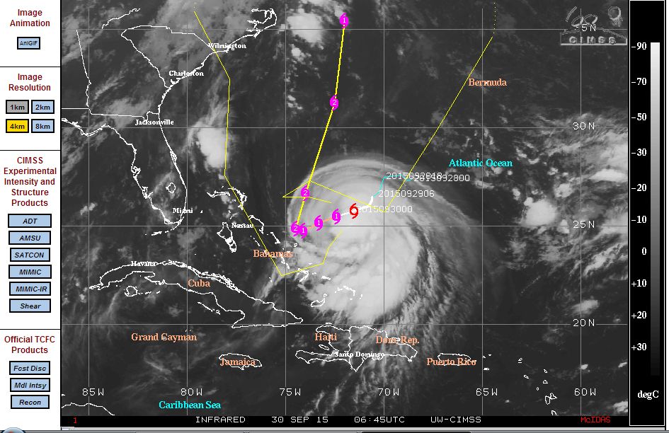
A new storm forming just north of the Tropic of Cancer and east of the Bahamas at latitude 25.6 degrees north and 72 degrees west have forecasters worried along the east coast of the United States. The storm is transitioning from a tropical storm into a Category 1 hurricane fast and is expected to complete the transition within the next 12 hours.
The storm is already named “Tropical Storm Joaquin” and the forecast models indicate some margin of error. The CIMSS forecast cone suggests the possibility of the system making landfall along the east coast of the United States.
The storm is well supported by seas surface temperatures of 28C to 30C although such temperatures drop sharply further north. Forecast models indicate the storm sustaining winds approaching 70 knots (Approximately 129 km/h) within 12 hours which is just above the threshold of a Category 1 hurricane.
The model indicates the storm reaching Category 2 strength within 36 hours with winds at the core reaching 80 knots or approximately 148 km/h and 90 knots or approximately 167 km/h within 72 hours. Some weakening is envisaged thereafter as the storm tracks further north.
The forecast model is suggesting the storm to track south west towards the Bahamas then make a sharp turn towards the north, north east. This is of concern because the storm would travel parallel to the east coast of the United States but remain out to sea for a period. Should the storm follow the forecast path, it would approach Long Island and eventually the Boston region. Sea surface temperatures in that region are much cooler than 27C thus the storm would weaken somewhat as it reaches higher latitudes.
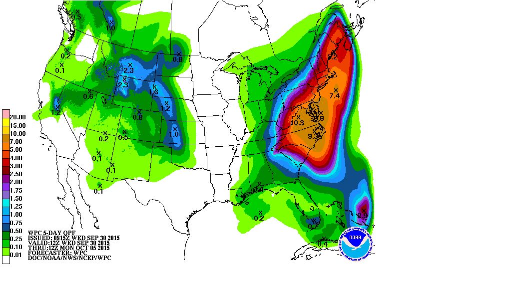
What is of concern the most is that another weather system over the eastern part of the United States is set to produce significant rainfall and storm events across the north east and east. There are heavy rain warnings in place and forecast models suggest as much as 175 mm falling within some areas. Models from the National Weather Service are showing a large area of the north east expecting to receive at least 100 mm with some areas across North Carolina, Virginia, Delaware and New Jersey forecast to receive upwards of 175 mm over coming days. Even New York City is forecast to receive as much as 125 mm over the next 5 days from the rain event.
The 5 day rain model is attached from NOAA which shows this.
The matter of concern is how will Tropical Storm / Hurricane Joaquin affect the region. The storm is forecast to move north and could interact with the system which will intensify rainfall amounts and flooding potential. It will be a busy time for forecasters as the two weather systems encroach one another.
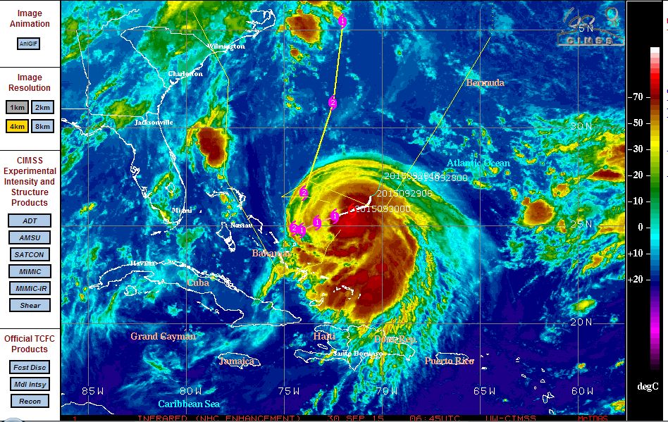
The CIMSS satellite photo of Joaquin shows an intense storm out to sea but with no eye and deep convection being a feature.
With the two storms close together, the first of the rains will be beneficial but too much rainfall will lead to flooding. It will be an interesting few days along the east coast of the United States due to the presence of the two weather systems close to one another.
CREDITS
1 - CIMSS - Satellite images and models acquired 29 and 30 September 2015.
2 - NOAA - Rainfall model acquired 29 September 2015.
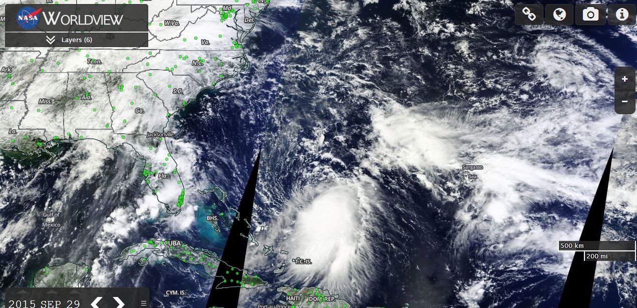
3 - NASA (Worldview with overlays including place names) acquired 29 September 2015.
Based on latest forecast models and forecast cones, it appears that eastern United States may be spared landfall from the Hurricane. The hurricane has intensified to a powerful category 4 storm over the Bahamas with air force reconnaissance investigations revealing winds of 117 knots at the surface. An aircraft fly through at 700 MB flight level has identified winds of 123 knots (Approximately 228 km/h). The threat of landfall which existed until recent hours appears to be decreasing.
The storm intensified to category 4 at latitude 22.9 degrees north and 74.2 degrees west and is battering the Bahamas Islands however, all the tracks and forecast models are showing the storm to move north to parallel the eastern coast of the United States. The storm should remain at to sea.
However, this does not mean eastern United States is spared heavy rain. A separate weather system is producing heavy rain and over the past 7 days rainfall totals have reached 150 to 200 along parts of the coastal regions with more to come. A flood issue exists and flooding is expected. This is likely to be covered by a separate thread because even without Hurricane Joaquin, this event is significant in itself.
Strong coastal surf and rainfall from the hurricane will still be an issue over coming days and significant rainfall is expected as the two weather systems prevail.