A major rain event across the states of Delaware, Maryland, New Jersey and Virginia have forecasters and authorities worried. As identified in another discussion thread, a significant weather event is unfolding across a large swathe of eastern United States of America in which days of heavy rain and storms is leading to a flooding emergency.
Until recently, there were fears that a major hurricane (Hurricane Joaquin) could make landfall across north Carolina which would worsen the situation. However after battering the Bahamas Islands, that storm has now peaked in intensity and starting to weaken. Hurricane Joaquin is moving north east and further away from coastal United States and no longer presents a threat. That storm should now decay over open ocean.
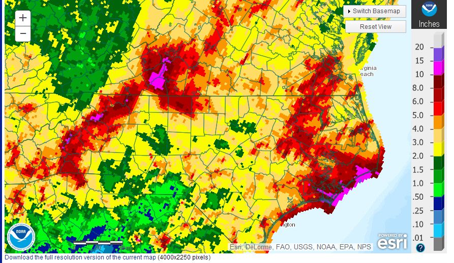
Notwithstanding this, the weather event impacting eastern United States for the 7 day period to Friday 2 October has already brought heavy rainfall in excess of 150 to 200 mm to many areas. The heaviest falls have been occurring over North Carolina and parts of southern Virginia where between 10 and 15 inches or 250 mm to 375 mm of rain has fallen during the past 7 days. In addition, a substantial area has received at least 50 to 100 mm during the past 7 days.
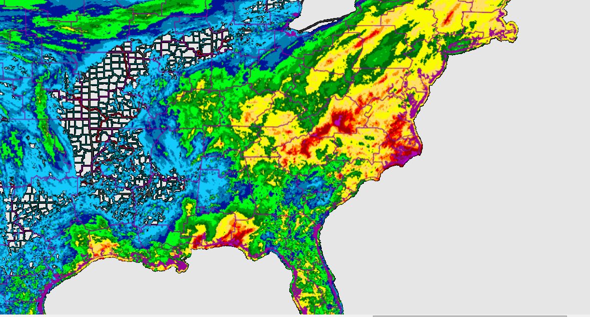
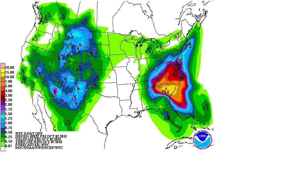
More concerning and as shown in the NOAA rainfall forecast plot for the next 5 days (Taken 2/10/15), a forecast of a further 10 to 15 inches (250 to 375 mm) of rain is being made for a majority of North Carolina with significant falls across a swathe of north east United States. Such rainfall would only worsen a flooding situation.
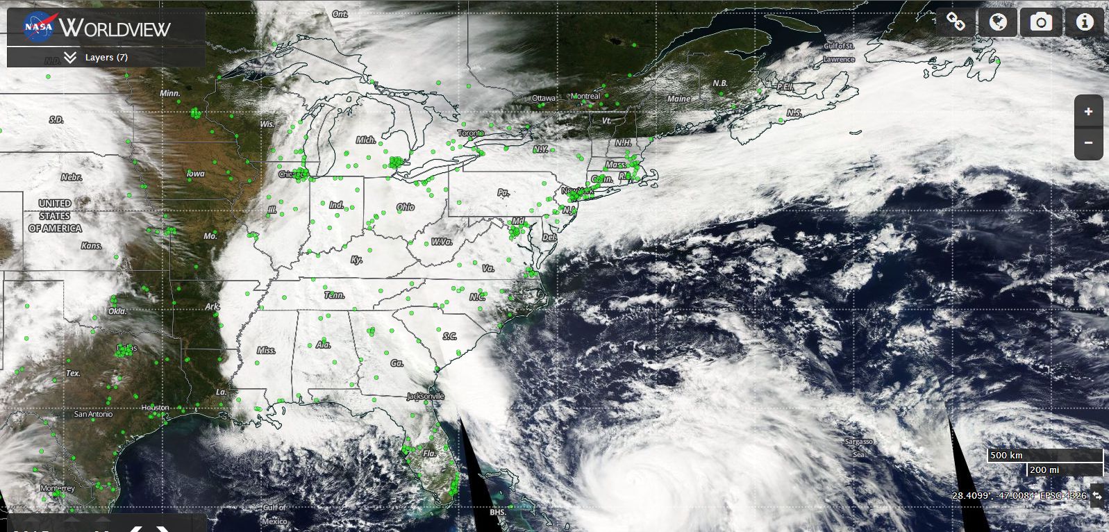
As shown on the attached MODIS Worldview satellite image of the eastern USA (3/10/15), even without the impact of Hurricane Joaquin making landfall, it can be seen that a large swathe of eastern United States is under heavy cloud which is producing so much rain over certain states. The cloud shown is impacting most eastern states.
Currently flash flood warnings and watches and coastal flood warnings are in place for areas of northern Georgia, South Carolina and North Carolina.
As an example “Record Rainfall and Life Threatening Flash Flooding” warning is issued for Moncks Corner (Berkeley County). The overview is suggesting a significant flooding event that is developing across southern South Carolina and portions of Eastern Georgia. “A powerful low pressure system over SE United States will slowly move NE across the area through Sunday. Several weather hazards accompany this storm most notably the potential for dangerous flooding from heavy rainfall and high tides” (National Weather Service 3/10/15).
An area around Charleston is forecast to receive 8 to 10 inches of rain through Sunday with Moncks Corner, Summervill and Walterboro being heavily affected. Residents in such areas are being warned for potential flooding. Already substantial rain has fallen in this area over the past 3 days.
The National Weather Service at Wilmington (North Carolina) has given some 24 hour rainfall at some locations in North Carolina 3/10/15:-
Bladen County
Elizabethtown (4 NNE) 6.68 inches.
Elizabethtown 5.44 inches
Rainage at William 4.6 inches.
Brunswick County
Calabash 9.04 inches - Converted to 229.6 mm.
Longwood 7.04 inches.
Sunset Beach 6.63 inches.
Leland 4.86 inches.
Horry County
Little River (16 inches) - Converted to 406.4 mm.
North Myrtle Beach 15.86 inches - Converted to 402.8 mm.
Buck Creek 8.22 inches - Converted to 208.8 mm.
This is showing some very significant rainfall of up to 406 mm falling across Horry County.
There are 61 river gauges showing flooding with four of those showing major flooding and 13 showing moderate flooding. If Virginia is used as a small sample, then major flooding is occurring at James River at Jamestown Scotland Ferry while 5 locations around Chesapeak Bay show moderate flooding.
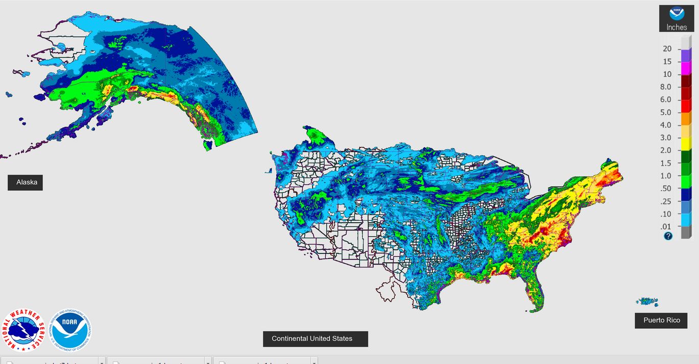
A rainfall plot generated on the 2 October for the 7 day period on the National Weather Service site demonstrates what is occurring in terms of rainfall. It shows the whole eastern United States as being wet.
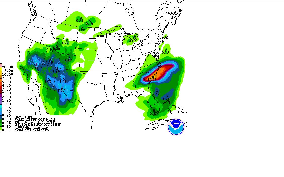
Notwithstanding such heavy rain, it appears the rain will ease within 3 days as longer range rainfall plots suggest rainfall easing after Day 3 (Quantitative Precipitation Forecasts) although not before another deluge of as much as 250 to 375 mm to limited locations occur.
CREDITS
1 - NASA (Worldview MODIS) Image with overlays (Modified to include location of urban centres and latitude and longitude) Acquired from NASA 3/10/15.
2 - NOAA (Rainfall plots) and rainfall forecast plots acquired 3 and 4 October 2015.
3 - National Weather Service USA (Rainfall figures) for 3 October 2015.
Some of the rainfall from the event is described as incredible with numerous rain gauges recording major rainfall totals. According to Accuweather records, the highest rainfall is 26.88 inches (Approximately 682 mm) at Cainhoy.
The National Weather Service has provided a detailed account of the rainfall that fell some of which are stated below. The figures are in inches but are converted to mm. The figures are for the period 12 am Friday 2 October to Tuesday 6 October 2015 for North Carolina which is within the area worst hit by the rainfall.
NORTH CAROLINA
Bladen county
Elizabethtown 11.73 inches or 297.9 mm.
Cape Fear 9.11 inches or 231.4 mm.
Brunswick County
Calabash 22.25 inches or 565 mm.
Leland 20.1 inches 510.5 mm.
Sunset Beach 20.09 inches or 510.2 mm.
Longwood 18.79 inches or 477.2 mm.
Varnumtown 16.4 inches or 416.5 mm.
Columbus County
Tabor City 14.69 inches or 372.1 mm.
Lake Waccoman 12.82 inches or 325.6 mm.
New Hanover County
Kure Beach 15.23 inches or 386.8 mm.
Bayshore 14.99 inches or 380.7 mm.
Florence County
Coward 5 NNW 17.99 inches or 456.9 mm.
Effingham 17.95 inches or 455.9 mm.
Florence 15.08 inches or 382 mm.
Georgetown County
Georgetown 21.13 inches or 536.7 mm.
Horry County
Longs 23.74 inches or 603 mm.
Myrtle Beach 21.9 inches or 556.2 mm.
Conway 18.81 inches or 477.8 mm.
Williamsburg County
Kingstree 24.75 inches or 628.6 mm.
Kingstree 10 NW 23.64 inches 600.5 mm.
So much rain fell that the equivalent of several months of rain fell at many locations and repairs will take months to complete. Flood waters will slowly recede leaving a major clean up to complete.
The event is labelled a 1 in 50 to a 1 in 200 year event depending on location. There are claims that some coastal locations may have had a 1 in 1,000 year event however this would depend on the accuracy of recording data and historical records and thus that is not confirmed.
As at 7 October 2015, media reports identify 17 fatalities from this weather event from vehicle accidents to drownings.
CREDITS
National Weather Service (Rainfall data) October 6 2015.
Accuweather (Rainfall data) 7/10/2015.