Michael,
Pity you missed the clear air strikes as they make pretty good pictures.
I have basically recovered from the mosquito bites I think. It was difficult to wear shoes.
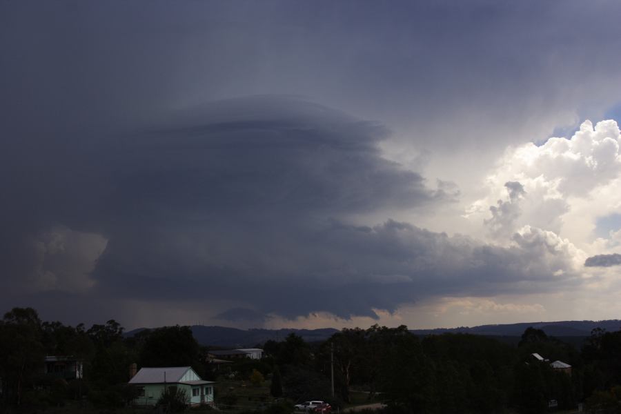
On another note, the hail at Lithgow yesterday as well as storm structure was apparently amazing! I thought why not include a picture here.
Here is a video footage of the event!
Jimmy
To tell the truth, we were still in Mt Victoria and wandering what next when we saw something unusual to our west – two boundaries were intersecting to our west under what seemed to be a weak cumulonimbus which obviously then exploded. I recall both David and I noticed this simulateneously and I walked to discuss if he had seen it and he had! Triple point was going to punch through the cap explosively!
Finally I am able to post this magnificent long lived supercell. This represents some of the best timelapse givent the storm was almost approaching us (myself, Dave Croan and Paul Graham). Even to this day, we look at this storm in awe. It was that close at producing a tornado over or near Lithgow and not far from our location.
And today is the anniversary of this event!
Six years ago today! This storm had the longest beaver tail I've ever seen!
I think it would be good to do some analysis on this event considering how significant it was.
Echoing Jeff's comment – It would be excellent to see some further analysis on this event, particularly given how lean the last few seasons have been!
I totally regret not dropping everything and leaving earlier for this storm chase! This is still the longest beaver tail I have ever seen and it stretched for probably 20km’s.
I went down to Hartley and tried to go back up to Bell but the road to Darling Causeway was blocked by a mud and rock flow. The area had seen a bad fire in the weeks earlier and the hills denuded of undergrowth couldn’t cope with the extreme rainfall.
The mammatus display from this storm from Sydney was phenomenal!
More mammatus
You know I was going through my old chase records and 2007 could possibly have been my last successful second chase season. I have photos from quite a few powerful storm events through February and March 2007.
Yeah – long and very thick! That was what got me – it shows in the video!
Furthermore, the dynamics behind storms with beaver tails are that they are undergoing conditions that could lead to tornadogenesis. The rotation was quite significant though perhaps just not sufficient for a tornado touchdown. There were a couple of wall clouds early on and it seems possible funnel cloud where we were in the region of rotation.