
In a remote area of the Indian Ocean, a tropical storm continues to intensify then weaken only to redevelop making forecasting very challenging.
The named storm is forecast to develop into a weak tropical cyclone over coming days. However only two days ago on February 14, a forecast was made for the storm to develop into a strong Category 3 storm on the Saffir Simpson Scale. That forecast is downgraded significantly and there is even the chance it may not properly transition into a tropical cyclone at all.
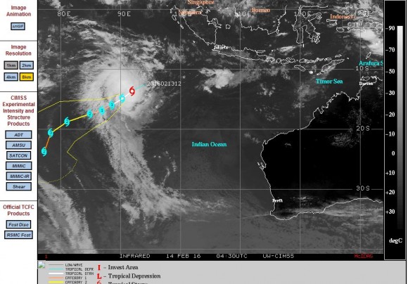
The named storm “Uhriah” developed relatively close but south west of Java (Indonesia) and travelled south west but is expected take a more southerly direction over coming days.
The storm has formed over waters of 29C which would support a tropical cyclone however it appears the storm has been significantly affected by sheer which at one stage, almost tore the storm apart. The storm has managed to redevelop after losing much of its structure. It sustains a small but intense core and an eye has been visible in satellite photos.
At the time of writing the storm is situated at latitude 17.9 degrees south and 84.7 degrees east placing it deep within the Indian Ocean with no imminent threat of landfall. It is possible that the storm will not make landfall during its lifespan.
It sustains winds of 55 knots or approximately 102 km/h near the core. It borders on the transition to a tropical cyclone and if it does so, then its maximum strength is expected to be a Category 1 storm throughout its life span with peak winds to 80 knots or 148 km/h.
What makes this storm interesting that despite the sheer that nearly pulls the storm apart, it has maintained some degree of structure over the past 3 or 4 days. Eventually the storm will weaken as it encounters colder waters further south.
CREDITS
1- CIMSS (Forecast plots for Tropical Storm Uhriah) dated 16/2/2016.
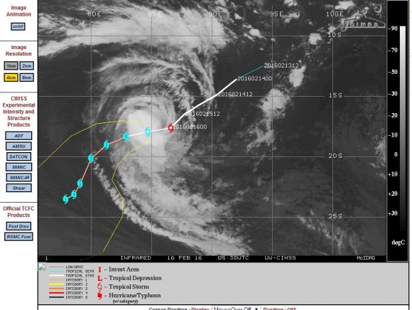
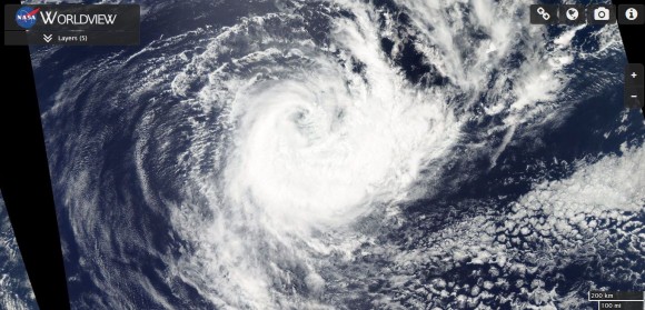
2 - NASA (MODIS Worldview satellite image of Uhriah) acquired 16/2/2016.
Further to the post of the 16/2/2016, tropical storm Uhriah appears to have moved into a more favourable environment over the past 24 hours and as such has transitioned into a strong Category 3 Tropical Cyclone quite suddenly.
It was only 24 hours previously that weather models were showing the storm struggling to develop and two days previously, the storm almost broke apart due to sheer.
The storm is tracking south west but with less sheer to contend with, the storm has consolidated and developed an eye over the past few hours.
Tropical Cyclone Uhriah is now the strongest storm of the summer season 2015/16 within the South Indian Ocean sustaining winds of 105 knots close to the core which is approximately 195 km/h.
Forecast models now suggest the storm to reach Category 4 on the Saffir Simpson Scale as follows:-
12 hours – Forecast winds to reach 120 knots or 222 km/h with peak gusts to 130 knots or 240 km/h.
24 hours – Forecast winds to reach 130 knots or 240 km/h with peak gusts to 145 knots or 268 km/h.
At 36 hours models suggest the storm to commence its final weakening phase as it encounters colder waters south of the Tropic of Capricorn.
This shows how difficult forecasting has been for this storm system. It appears that the storm will never make landfall due to its position far away from any landmasses.
This is shown in the attached model from CIMSS acquired 17/2/2016.