
A strong and vigorous monsoon low across the inland or base of the top end of the Northern Territory has forecasters concerned. On Christmas Eve, the low pressure cell was inland but south of Darwin.
It is forecast to move east then south east. There is the possibility of the low crossing the coast and transitioning into Australia's first tropical cyclone of the season.
If it does not it will certainly cause heavy to very heavy rainfall and certain flooding in low lying areas of the Gulf Country of Queensland and Northern Territory.
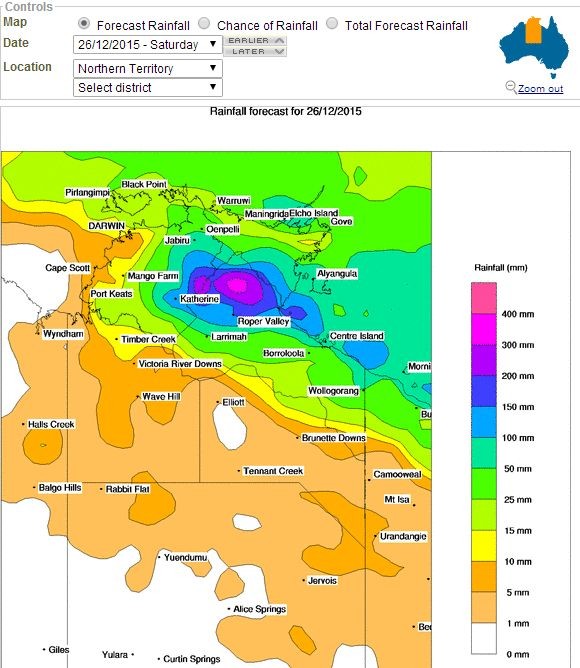
Rainfall models are forecasting in excess of 400 mm of rain from the event across some regions.
During Thursday and Friday, the monsoonal trough and low signaled its early intentions across the Top End where heavy rain and flooding occurred. Fortunately other than Darwin, most of the top end is uninhabited and hence the flooding is occurring across rural areas and within creek and river crossings.
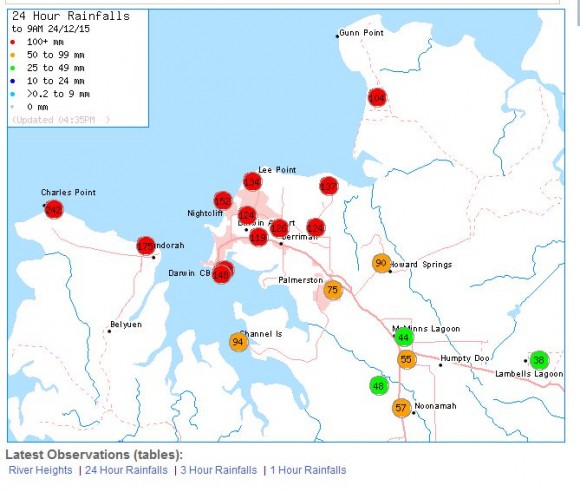
Up until 9 am 24/12/2015, 119.4 mm of rain fell at Darwin International Airport. A weather station at Dum In Mirrie recorded 235.8 mm. Other big rainfall totals include:-
Charles Point - 242 mm.
Adelaide River - 198 mm.
Wagait Beach - 175 mm.
Up until 3.00 am 25/12/2015, the following rainfall had been recorded:-
Upper Adelaide River 164 mm.
Port Keats 155 mm.
Dum In Mirrie 139 mm.
For Dum In Mirrie, this is 375 mm when combined which is easily enough for major flooding to occur.
The next four days will be difficult weather wise across the top end and Darwin. In particular, storms and very heavy rain is being forecast for large areas. For Darwin 30 to 80 mm is forecast for Christmas Day but heavier totals of 170 mm is not being ruled out during thunderstorm events.
The development of any tropical cyclone will also create further issues in coming days across the eastern top end. The storm has not been named at the present time but it is receiving very close attention.
To support this article, the following is provided:-
1 - Rainfall plot for Darwin to 9 am 24/12/2014 (Bureau of Meteorology).
2 - Forecast rainfall plot for the top end (Northern Territory) for the 26/12/2015 (Bureau of Meteorology Water and the Land).
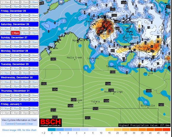
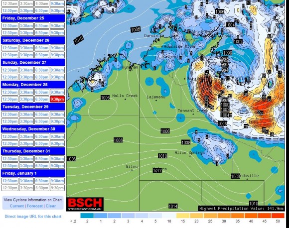
3 - Position of the monsoon low for 3.30 pm Saturday 26/12/2015 (BSCH).
4 - Forecast position of the low (Possible tropical cyclone) 3.30 pm 27/12/15 (BSCH).
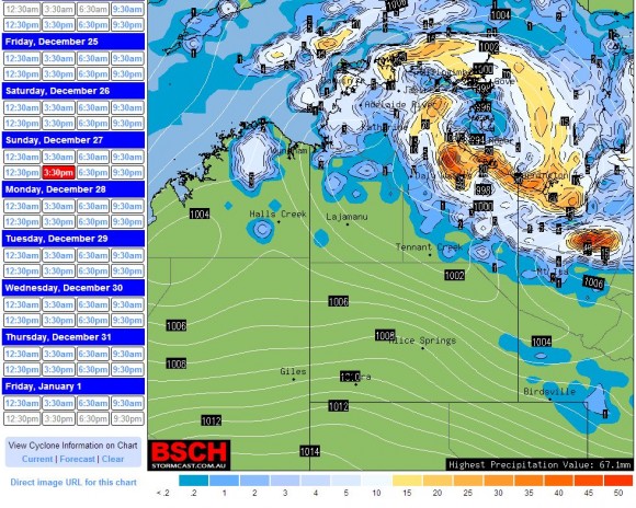
5 - Forecast position of the low (Possible tropical cyclone) 9.30 pm 28/12/15 (BSCH).
For the 24 hours to 9 am 25/12/2015, some very heavy rainfall has been recorded south west of Darwin from this system. This includes:-
Gourley – 339 mm.
Beeboom Crossing weather station – 310 mm.
Mango Farm – 226 mm.
Port Keats or Wadeye (South west of Darwin) – 220.4 mm.
Daly River Police Station – 190 mm.
Across Darwin city and its near hinterland, falls ranged from 38 mm at Channel Island to 113 mm at Charles Point.
This shows the strength of the monsoon trough and what this system is capable of doing.
It is still not clear whether this low will transition into a tropical cyclone or not. The low pressure cell is taking its time to cross the base of the Top End but it is moving slowly east.
Rainfall appears to be easing in Darwin.
If the low crosses the east coast then it could develop into a tropical cyclone. If not, it will remain a low pressure cell. This is still not certain.
The low pressure cell and associated cloud mass has dropped an incredible 570 mm of rain to Beeboom Crossing for the 48 hours until 9 am 26/12/2015. This is made up of 310 mm for the 25/12/15 and another 260 mm to 9 am 26/12/2015.
Other substantial rainfall totals to 9 am 26/12/15 includes:-
Bradshaw – 284 mm.
Gourley – 278 mm (This is an incredible 617 mm in 2 days).
Mathieson – 277 mm.
Mango Farm – 236 mm (48 hour total is 462 mm).
Bonalbo – 230 mm.
The Pines – 194 mm.
All the localities are south and south west of Darwin and such heavy rain has cut local roads and making vehicular access to the region difficult. The area is relatively flat with low lying ridges and there are no mountain ranges to modify rainfall. The slow movement of the low is contributing to such high rainfall totals.