Significant Rain Event - Death Valley Flash Flood Furnace Creek - Friday 5 August 2022
Occasionally over the years, I have described some of the extreme weather events that have occurred within an area called “Death Valley” situated in eastern California. These have generally been associated with extreme heat and heatwaves but none have been associated with heavy rain or flash floods.
However, on the morning of Friday 5 August 2022, a flash flood event impacted parts of the valley which has established a new weather record for Furnace Creek.
Death Valley Topographical Climatic Influence
Death Valley is situated in an area which is starved of rain. There are 4 mountain ranges to the west of the valley including the coastal ranges of California, the Sierra Nevada mountains which rises to over 4,000 metres in places, the Inyo Mountains and the Panamint Range. Telescope Peak overlooking the valley to the west forms the highest point of the Panamint range at 3,368 metres or 11,049 feet. By the time air reaches the valley, it is starved of moisture.
Death Valley is the driest location of North America and given location and topography, weather stations located here often record summer daytime temperatures of 50C and minimum overnight temperatures of 38C and 40C are recorded in most years. Summer rainfall is quite rare and heavy rainfall is even rarer, almost non existent.
Temperatures of 54C have also been recorded here in recent years.
There are weather stations at Furnace Creek (The Visitor Centre) and at Badwater Basin to the south.
My Photos from a trip in the Deathe Valley Region
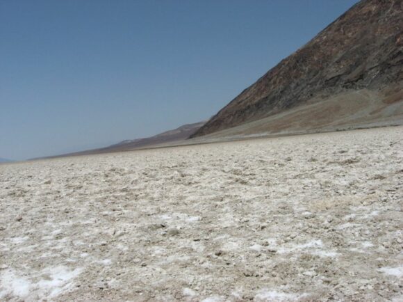
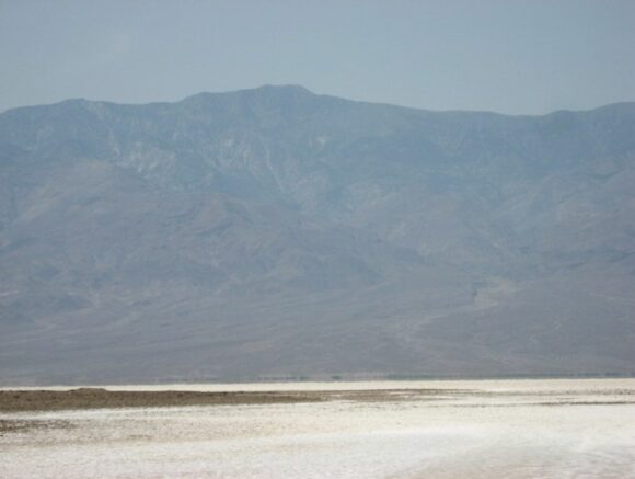
The photos attached to this post at Badwater Basin were taken in June 2007 during a visit to this inhospitable place. They show the topography, the geography and importantly, the lack of vegetation that exists. The views are to the north and west with the western view showing Telescope Peak in the distance.
On the day of the event...
On the morning of Friday August 5 2022, a rare flash flood / thunderstorm event occurred within this valley impacting the Furnace Creek Visitor Centre, Badwater Basin and surrounding areas. This event produced 37 mm of rain or 75% of the yearly average rainfall. While 37 mm of rain is not significant in itself, it is a major event within this area especially given that there is no vegetation to slow the water. Rainfall washed down into valleys as flash floods which damaged roads and visitors became trapped at the visitor centre.
Rainfall Totals and Data for Furnace Creek
This event has set a new August rainfall record for Furnace Creek and has come very close to the all time daily rainfall record of 1988 being 37.3 mm (Recorded April 15 1988).
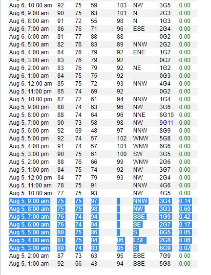
The weather station at Furnace Creek recorded the following:
3 am 0.5 mm.
4 am 1.5 mm.
5 am 1.27 mm.
6 am 4.3 mm.
7 am 10.66 mm.
8 am 15.24 mm
9 am 3.5 mm.
Total 36.9 mm.
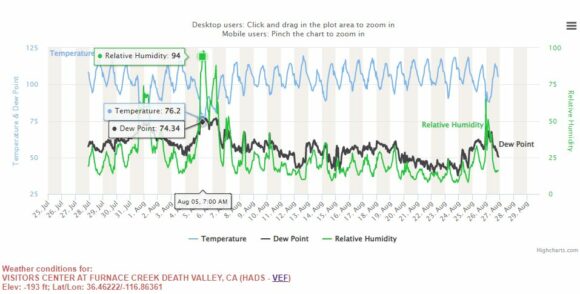
The event occurred between 3 am and 9 am (morning) with the heaviest rainfall occurring between 7 am and 9 am. This event resulted in a cooler than normal day with the maximum temperature peaking at just 33C for the day.
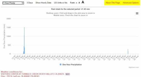
Interesting, there has been another minor rain event of 4.5 mm on Friday August 26. As such, it has been unusually wet for August 2022 especially given that the average August rainfall is less than 2 mm.
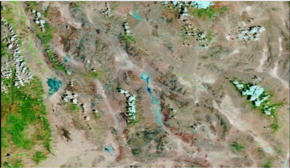
The NASA MODIS (Terra and Aqua) satellite image attached clearly shows floodwaters (Shown as light blue) ponding along the valley floor following the flash flood. Usually this is an alkaline salt pan of crusted salt which is shown by my photos and usually baked by the sun.
My photos attached shows the area where the water would have ponded following the flash flood being Badwater Basin.
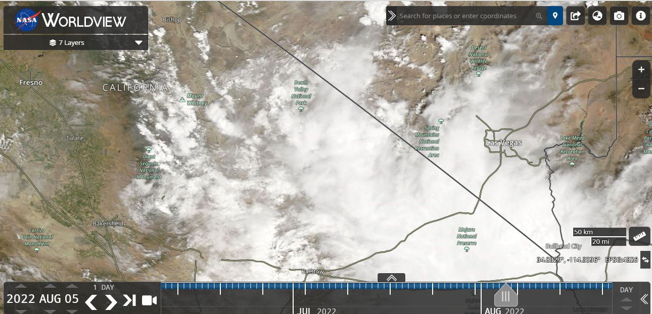
As shown on the NASA Worldview image of Friday 5 August 2022, much of the region was under cloud. Cumulonimbus cloud formations are identifiable south east of Death Valley at the time the image was taken.
Generally, this event was truly extreme in nature and demonstrates just how extreme the weather can be in Death Valley California.
Source
- National Weather Service (Furnace Creek Observations) August 2022.
- NASA Worldview Images and Satellite photos.
- Ground level photos taken on site in June 2007 being the location subject to the flooding and water ponding.
