 Storms have erupted over the ranges near Sydney and eastern NSW and are becomign widespread. The Bureau of Meteorology have issued severe storm warnings for Sydney region, Illawarra, Central Tablelands, Hunter and regions north and northeast of these areas. The lastest models have an upper trough approaching the region and the air ahead of it is sufficiently unstable to produce severe storms including hailstones but in particular heavy rainfall that may lead to flooding and strong winds being the main threat. Anyone travelling should stay alert to the latest warnings. For live coverage complete with live radar overlay, refer to the Early Warning Network. Some areas may experience rainfall of up to 60mm of rain in eastern NSW.
23 thought on “Severe storm warnings for Sydney and eastern NSW 1st February 2013”
Leave a Reply
You must be logged in to post a comment.
Sydney is about to get hit by an elevated bowing line. I am located near Penrith at the moment which should be impacted soon!
Another bow echo rapidly approaching from the north west near Putty. Raining here right now from redevelopment ahead of the original line!
Hi Jimmy, I was watching the cells near Oberon and was heading up the Mountains when they rapidly developed forward of the line and impacted Mt Boyce before I could get there. After looking at the radar and doppler you can clearly see the wind change reaching the storm line near Oberon right before its rapid intensification. Gotta watch those wind changes more carefully!
Yep definitely Jeff but in hindsight it is always easier to reflect – particularly when our target was further north in northern NSW. Personally, I am happy with the decision not to go as once again if you go there with the intension of seeing supercells and then get a squall line, you get a little cheesed off. Nevertheless, it seems we got to see via Matt Smith what was up there. Matt, can you post a couple of photographs when you get a chance.
Thanks.
I went up to Singleton to try and keep away from the southerly change passing through. Late morning and early afternoon, I saw stronger or quite reasonable cumulonimbus cloud towers build over the ranges to the west and south west. A few of these were solid and I was able to take some long distant photos of the cloud towers.
At Singleton, the winds were a very warm NW when I arrived. Late morning or near midday, a small thunderstorm passed over the town. This was an elevated storm and had a high base but a number of thunderclaps were heard. A few of these were moderately loud. Once that passed over, I could see the wind change impacting the eastern parts of the Hunter Valley and the associated low cloud with it off to the east and south.
New storm cells briefly developed on this wind change to the east and south but they collapsed very fast as the change moved through. Personally, I have never seen thunderstorm cells build then collapse so fast. It was pointless driving to these because once a cloud tower would build to a reasonable height, a rain shaft would develop and the cloud tower would rapidly decay.
However, I did have the benefit of having relatively clear skies without low cloud so I could see what was going on. I was fortunate enough to be far enough inland from the coast and did not experience the wind change till near 2 pm. At Singleton, the wind change brought a strong easterly wind and that started to tend back to the east north east after an hour.
I could clearly see a line of storms approaching from the west mid to late afternoon. While some low cloud built up between 2 pm and 4 pm, there were enough breaks for me to see what was going on. A squall line came through around 4 pm. This brought ocassional lightning and moderate rain and another wind change, back to the west then south west.
Initially there was not a significant number of lightning flashes but the amount did increase during the passage of the storm system. I chased this back to Maitland. It was interesting to see the rain intensity increase as I approached the coast. Near Maitland, I saw 3 cloud to ground lightning strikes to the east and these were the first seen during the whole day. Most lightning seen was within the cloud.
At Maitland, I did encounter some sustained moderate to heavy rainfall which was heavier than what I had at Singleton.
I then made my way back to Sydney passing through the last of the rain squalls which completed the day.
Today seems to have panned out as expected with earlier activity near and north of Sydney, then North West Slopes and Mid-North Coast and the further north beyond Narrabri and southern Queensland as I type. The northern storms were more likely to be strong wind producers nod shallow storms given the unusually warm temperatures aloft. Some good rainfall over the central coastal areas and adjacent ranges by this evening. Harley Pearman, I hope you don't mind producing a rainfall report for this event.
I will work on that. What I saw in the Hunter Valley just prior to the squall line coming through, storms were initially hit and miss and in some respects, one had to be right underneath the cloud tower to experience any downpour.
Once the main system came through, rainfall was more general and widespread but not heavy in all areas. I managed to chase the squall from Singleton to Maitland and I found much heavier rain around Maitland than at Singleton.
I could see the entire system stretching all the way to the north. I did not see a thick anvil cloud but just the leading edge of cirrus cloud which gradually thickened and numerous updraft cloud towers horizon to horizon making up the squall line. This was very hard to photograph due to some low cloud coming in from the east and some haze.
Some rainfall figures provided are:-
1 – Sydney 4.5 mm to 32 mm with 4.5 mm at Narrabeen to 32 mm at nearby Dee Why.
2 – 16 mm at St Marys, 24 mm at Penrith, 25 mm at Prospect, 27 mm at Observatory Hill and 30 mm around Campbelltown and Richmond.
Generally, most rainfalls vary between 16 and 30 mm for most of the city region.
Central Coast:- Some heavier falls occurred including a reading of 62 mm at Station Number 61383 being Gears (Wyong River) and 37 mm at Mangrove Mountain. I could tell heavier rain had fallen because I did encounter some water on the roadside of the F3 on my way home.
Maitland had 20 mm but only 11 to 13 mm around Singleton. There is a fall of 56 mm at Barrington. I did see a storm cell tower in this area but that collapsed rather quickly. Some of that must have been from the early afternoon storm in that area in addition to the main squall line later on.
Towards Tamworth, there is a rainfall reading of 78 mm at Weabonga although much lighter falls elsewhere.
There are big readings around Port Macquarie including 51 mm at Hastings River and 59 mm at Kooroowi but lighter falls elsewhere.
On the Central Tablelands much lighter falls of 5 to 9 mm occurred around Bathurst.
Here is a photo of the typical storms that developed in the Singleton area today.
Here is one more. In the lower portion of the picture above, the low cloud from that wind change can be seen. This looks like a robust storm but it did not last long. This was elevated above the wind change. Storm towers earlier in the day (Photo two).
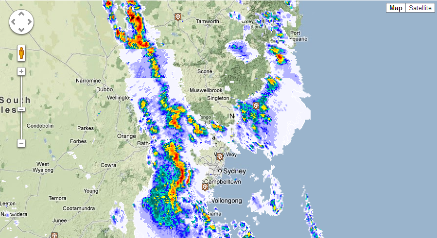
Another wave of storms are approaching due to the upper trough and associated cooler air coming through overnight.
Weatherzone Radar of the approaching line.
Another line forming on the convergence line west of Wellington.
Here is an image of the squall approaching Singleton from the west. This came in fast but I did not see significant lightning flashes in it at this stage.
I wish I was Standing on the coast at Forster right now! Would be a good chance of seeing waterspouts with such a strong system moving up the coast.
I’m not too worried about not heading up to Mullaley. There will always be better oppurtunitys’ for severe storms. I was a little anoyed though that I didn’t pay attention to the wind change yesterday when chasing locally. I would have left earlier otherwise and may have been in a better position to see some hail.
Overnight further rainfall from this event boosted rainfall totals. For the 24 hours from 9 am to 9 am 1 February 2013 to 2 February 2013, rainfall totals include:-
For Sydney region
1 – Blacktown 38 mm, Penrith 42 mm, Richmond 46 mm. The heaviest falls occurred over eastern and north eastern areas of Sydney with 52 mm at Observatory Hill and 64 mm at Bondi being the highest figure for the period.
Outside Sydney
2 – Other strong falls close to Sydney include 55 mm at Wallsend Bowling Club (Newcastle), 55 mm at Katoomba, 57 mm at Kulnura and 59 mm at Zig Zag (Clarence). A fall of 74 mm occurred at Gears Weather Station and 66 mm fell at Wollombi.
3 – A locality called Weabonga SE of Tamworth recorded 83 mm.
4 – On the Southern Tablelands, a weather station at Taralga recorded 55 mm
There were some significant falls in the lower Hunter region east and north east of Singleton where totals between 50 and 89 mm occurred. These include 88 mm at Barrington and 89 mm at Dungog. For contrast only 23 mm fell at Singleton.
The heaviest falls were concentrated south of the Mid North Coast, Lower Hunter, isolated areas around Tamworth, Central Coast, Sydney and Wollongong for this event.
To tell you the truth Jeff, what we have been seeing lately is crap anyway compared to the yesteryear! What has happened to all those giant hail events etc. Second season here we come – hopefully!
We haven't had a good second season in years. It can only get better though, can't get much worse then its been
"..can't get much worse then its been.." And we said this each of the previous years too!
I also chased on this day with Stephen Jarrett,and it was a challenge…
Upper Hunter was the plan to keep ahead of the southerly scud fest. Bathurst did cross my mind, as upper temperatures would be colder and hail a better chance. The plan was Scone at first where we would re access the situation. Mid level cloud developed rapidly in the Hunter from mid morning onwards, and it was a struggle to find blue sky. Towers rapidly formed in the clearer air on the blue mountains well before midday. From here the situation evolved really quickly with a storm near Dubbo rapidly becoming linear. We headed southwest to Merriwa as skies were much much clearer there. Already a line of anvils could be seen on the western horizon. We pushed half way to Mudgee ,and the line looked reasonable for a while to our southwest with nice greenage and healthy updrafts at the front end of the line( 1:10pm) Unfortunately the line rapidly got overtaken by its own outflow, and sadly, freezing cold outflow pushed 50kms ahead of the line.
We rushed back into the Upper Hunter wanting to keep ahead of the line as you just never know what might happen with the southerly( southeasterly/easterly in the Upper Hunter). I was tempted to let the line roll overhead, and see what the cool pool could do following the line, but I didn’t do this. Some 100kms later, we finially got ahead of the outflow near Scone! But then we rapidly got overtaken by the change! A nice looking storm could be seen from Scone developing to our southeast near Singleton at 3:30pm , this contained to brilliant updrafts and some interesting little base features. Unfortunately this was unreachable,so we pushed up to Murrundi to meet up with the squall which seemed to intensify on Murrundi itself, perhaps on the convergence of the change( 4:10pm) If anything the southerly was acting as a source of inflow keeping the gustfront nice and consolidated for a short time there, however given the source of inflow was so cold, the storm collapsed. From here we got heavy rain, and a few hail stones approaching 1cm… We also saw our first bolts of the day, well entreched in the core. The feature we did note today was the lack of lightning maybe because of the warmer upper temps( at the 300 and above) ?
All in all a dissapointment. Cap went too early, and virtually every storm had a linear nature to them… Quite probrably my worst chase of the season…
Hi Michael,
Sorry to hear of your disappointment. Jeff and I were tempted to chase and I was almost ready to call Jeff. I looked further and something was not right – those subtle signs on the models – the standout were the warmer upper level temperatures and the upper trough was too far back to have a major impact eg for sustained and violent supercells. Do I take the day off and lose money? This was what was stacked against me. I personally was not convinced but then again it is easy in hindsight. I also toyed with the idea of racing after school up to Mudgee on earlier runs prior to the one on the morning. I got stuck in the school carpark with a line of parents picking up their childen – that ended my hopes on a dash up the coast for instance or at least racing in front of the line to the SE suburbs.
Michael, after reading your post, the storm you were watching was west south west of Singleton and that was the one I was watching from Singleton. It was reasonably close to me but looking at my maps, I discovered I could not get to it as it was affecting areas with no roads.
That cell was producing good updraft towers at one stage but the wind change must have affected it. It eventually passed over me with the main storm front later on and rainfall was only moderate but not heavy. It was disappointing but at least I was able to see what was going on without the low cloud obscuring the whole sky.