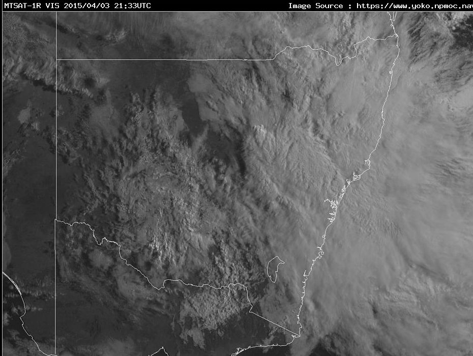
The satellite photo attached identifies a significant cloud mass occupying the eastern half of New South Wales as at 9 am / 10 am Saturday morning with some of that cloud spilling into the eastern central parts and parts of south west New South Wales. A moist onshore air stream and an eventual east coast low is creating this setup leading to a widespread rain event across the state of New South Wales. As identified in an earlier post, such a setup or rain event was anticipated.
The far west of the state and Victoria currently miss out on the rain event.
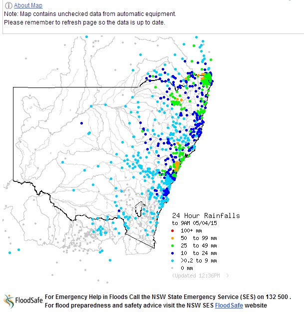
Rainfall is widespread and there are some isolated heavy rainfalls but it is interesting to note that to 9 am 4 April, rainfall is relatively uniform across the affected area.
Here in Sydney, the event started on the 3/4/2015 with light drizzle which tended to light steady rain during the afternoon. This continued overnight into Saturday morning. By 9 am 4/4/2015, the highest totals were:-
43 mm at Waitara.
39 mm at Hornsby.
35 mm at Chatswood.
32 mm at Richmond.
Across most of Sydney, rainfalls tended to be within the range of 10 to 30 mm with the higher totals of 30 to 40 mm around the hillier northern suburbs.
Further north on the Central Coast, some rainfall totals reached 50 to 99 mm for the same period including 87 mm at Blacksmith, 69 mm at Jilliby Creek, 66 mm at Wyee and 64 mm at Dora Creek.
Further north there are falls of 61 to 74 mm in and around Narribri (74 mm at Narribri and 73 mm at Narribri West).
On the north coast there is a very isolated fall of 175 mm at Bellingen and 90 mm at Dorrigo.
Given the size of the cloud mass covering New South Wales as seen in the satellite picture, it is clear this event will continue throughout Saturday with more rainfall to come.
The rain event continued throughout Saturday and eased during the evening. For the 24 hours to 5/4/2015, rainfall totals were not significant across Sydney. Generally:-
South west suburbs – rainfall ranged from 4 to 10 mm.
Eastern suburbs – rainfall ranged from 11 to 21 mm.
North east Sydney – rainfall ranged from 26 to 42 mm.
The highest rainfall totals across Sydney were:-
Terrey Hills – 42 mm.
Frenchs Forest – 38 mm.
Turramurra – 25 mm.
A big feature of this system for Sydney was the longevity rather than the heavy falls. For example the rain increased at Blacktown from around 3 pm Friday afternoon (Following light drizzle earlier) but eased late Saturday evening. Rainfall was steady where I live throughout this period with 21 mm and 9.6 mm falling (Cumulative total of 30.6 mm).
The Central Coast suburbs / cities including Gosford, Wyong, Erina, and Wyee saw the heaviest rainfalls. For the same period, the heaviest falls occurred at:-
Wyee Post Office – 89 mm.
Mount Elliot – 67 mm.
Jilliby Creek – 64 mm.
Kangy Angy – 59 mm.
Erina Heights – 58 mm.
Gosford 50 mm.
In terms of combined totals for Friday and Saturday, the Central Coast received the heavier falls with some places receiving more than 100 mm (Cumulative totals). For example, Wyee had a cumulative total of 155 mm while Jilliby Creek had a cumulative total of 133 mm.
Northern Tablelands – 9 am 5 April 2015:
Strong rainfalls occurred over parts of the Northern Tablelands during the period with an area around Glenn Innes receiving from 65 to 88 mm being the higher totals. Kings Plains received 95 mm being the highest total.
Inland South East Queensland – 9 am 5 April 2015:
A relatively small area inland and west from the Gold Coast also received significant enough totals with the highest being:-
Cannon Cove Alert – 162 mm (This is a very isolated heavy fall).
Boonah Alert – 108 mm.
Tarome – 107 mm.
Toohills Crossings – 102 mm.
Tarome Alert 101 mm.
Within this area, many places also received from 51 to 98 mm including Moongerah Dam HW Alert at 98 mm, Wards Road 94 mm and Knapps Creek on 89 mm.
The rain moved offshore rapidly overnight thus concluding the event. I have attached two relevant plots showing general totals to conclude the post.