Over recent days, weather models have been hinting at a number of rain events to impact much of coastal Southeastern Australia commencing Sunday 18 May and continuing through to Saturday 31 May.
Some of this should be questioned as models often change on a daily basis and the regions that are likely to be affected also change.
Over recent days, the GFS and various other models have hinted at significant rain events impacting Sydney, Newcastle and regions northwards towards Coffs Harbour. However, upon review of this, the same models have then been modified and expected rainfall totals have then decreased.
This is noted for Sydney in which between 0 and 30 mm is being forecast each day across Sydney for the next 6 days (Forecast made on Saturday) only to be revised to as much as 5 to 40 mm by Sunday morning.
The Saturday forecast would suggest cumulative totals of 6 mm to 105 mm between Sunday and Friday across the city but on Sunday morning, this is revised to cumulative totals of 12 to 110 mm for the same period.
This is not significant on a daily basis but it becomes more significant when added together.
Further north, the potential for heavier and higher cumulative totals increases and there appears to be concern for more significant rainfall totals within an area from Newcastle and the Hunter Valley northwards to Coffs Harbour.
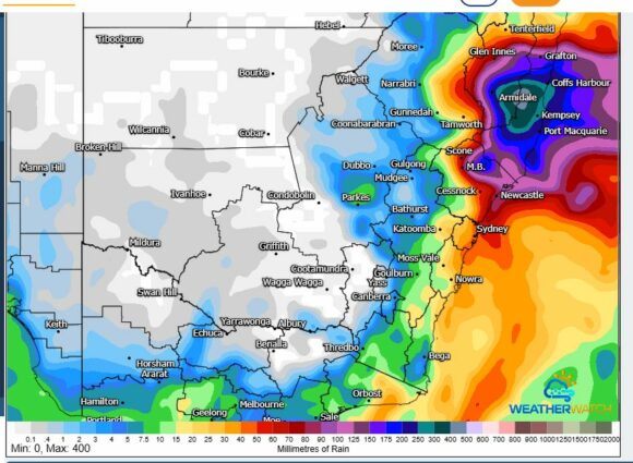
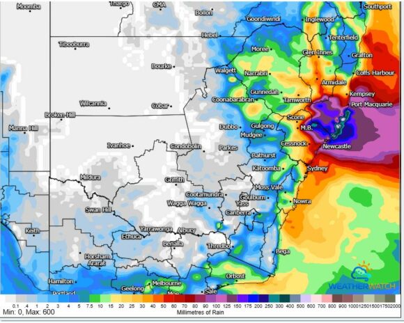
The GFS has been considered and it would appear at this stage that significant cumulative totals are earmarked for the Hunter Valley and an area between Port Macquarie and Coffs Harbour.
- The cumulative GFS model to the close of Wednesday is attached.
- The cumulative ACCESS G totals to Tuesday afternoon is also attached.
Both are showing a similar area to be impacted by higher rainfall totals of greater than 150 mm.


What is becoming clear is that a period is fast approaching in which persistent showery periods / rain periods across several days will be impacting the eastern parts of New South Wales with the heavier totals occurring across the Hunter Valley region, the north coast and regions north to Coffs Harbour.
The activity has potential to penetrate at times into the eastern inland regions of the state.
The potential for some flooding cannot be ruled out where the heavier totals occur.
Unfortunately, there is little to no chance of anything penetrating into the dry southwest region of the state where drought conditions are now taking hold.
Interesting when weather models are extended further into the future, some are showing potential for further rainfall across the south coast of New South Wales and potential for rainfall reaching into the southwest inland of the state including the dry regions around Albury and Wagga Wagga and beyond. At this stage, such forecasts should not be taken as any suggestion that drought breaking rains are on the immediate horizon because model ensembles do and will change.
The attached rainfall models only apply to Tuesday and Wednesday on the grounds that there is now reasonable reliability available across the next 3 to 4 days as to where the heavier rainfall totals are likely to occur.
