
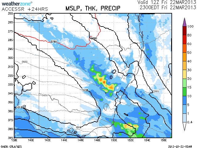
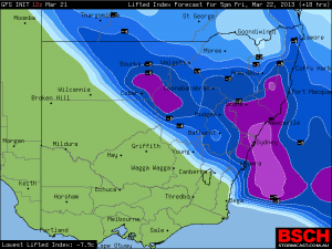
 Storms are again expected in eastern NSW today with some possibly severe. An upper level waves which affected Victoria yesterday is expected to impact the eastern part of the state in time for moist air and surface heating which should spawn the development of storms during the afternoon and evening.
Models are indicating some precipitation by late evening. The storm system will gradually head into northern NSW.
Warnings are already in place for the central NSW regions for central NSW already just issued.
TOP PRIORITY FOR IMMEDIATE BROADCAST.
SEVERE THUNDERSTORM WARNING.
for LARGE HAILSTONES, HEAVY RAINFALL and DAMAGING WIND.
For people in parts of the.
Central Tablelands,
North West Slopes and Plains,
Central West Slopes and Plains and.
Upper Western Forecast Districts.
Issued at 12:12 pm Friday, 22 March 2013.
Severe thunderstorms are likely to produce large hailstones, heavy rainfall that may lead to flash flooding and damaging winds in the warning area over the next several hours. Locations which may be affected include Mudgee, Dubbo, Coonabarabran, Wellington, Coonamble, Nyngan and Cobar.
TOP PRIORITY FOR IMMEDIATE BROADCAST
SEVERE THUNDERSTORM WARNING
for LARGE HAILSTONES, HEAVY RAINFALL and DAMAGING WIND
There already looks like a supercell north of Coonble
Did anything come out of that cell Jeff Brislane?
Don't know Jimmy, it certainly looked impressive on radar and the dew points were high out there.
I was so lazy being so busy and my mind is so much on the US that I have completely ignored the scrutinising of the data.