Almost every year, heavy rainfall and flooding occurs somewhere within the state of Queensland and the summer season of 2024/2025 is no different.
Occasionally multiple regions are impacted and on rarer occasions, such events impact coastal locations and inland locations at the same time.
During the period February and March 2025, heavy rainfall has been a feature and vast regions of the state have been impacted by significant rain events and even flooding.
During the period March 24 to March 29, an interesting picture is emerging from the most recent rain and flood event as follows:
- Daily rainfall figures have topped 100 mm and even 150 mm at various locations within the state on each and every day during the period.
- Falls of 200 mm and above have occurred on each day during the period March 24 to March 29.
- The city of Townsville received its third major rain event since early February.
- Major flooding has occurred at and around the city of Mackay.
- Rivers are in flood across the outback and small outback communities are or have been cut off by floodwaters.
If considered as one single event, then this could be regarded as the third major rain and flood event to impact the state since January.
Given the flatness of the country, the inland floods that are occurring will only recede slowly and much of the water will eventually drain into Lake Eyre (South Australia) and never reach the sea.
While much of the rain fell across eastern Northern Territory and Queensland during the period, some of this made its way into northern and eastern New South Wales during Friday and Saturday.
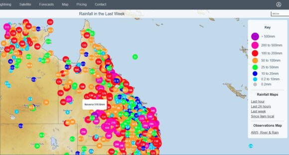
The event that started during Sunday was slow moving and is only crossing the coast 5 to 6 days later. As a result, rainfall accumulations during the period have topped 500 mm at isolated locations such as the 518.8 mm that fell at Navarra (Central Queensland) to 9 am Saturday. Numerous other locations have had 200 to 400 mm. Effectively, hardly any region of the state missed out.
Given the widespread nature of the event, a table is produced below which shows the most significant events occurring being:
- Those above 100 mm (Most significant):
- Those above 200 mm (Most significant).
| Date | Location | Rain - 100 mm | Rain 200 mm |
| 9 am Monday | Townsville City
Whites Creek. Annandale Alert. |
188 mm. 184 mm. |
|
| Adderley Station. | 201 mm. | ||
| Cottonbush Creek. | 142 mm. | ||
| 9 am Tuesday | Winton (Jundah Road). | 158 mm. | |
| Quilpie. | 130 mm. | ||
| Bellalie TM. | 129 mm. | ||
| Coastal QLD (South of Cairns) | |||
| Cardwell. | 239 mm. | ||
| Paluma. | 178 mm. | ||
| Mackade Sugarmill. | 165 mm. | ||
| Gairloch. | 110 mm. | ||
| 9 am Wednesday | Townsville City
The Pinnacles. |
151 mm. |
|
| Paluma. | 139 mm. | ||
| Inland regions | |||
| Winton (Jundah Road). | 242 mm. | ||
| Bogewong. | 230 mm. | ||
| Stonehenge TM. | 208 mm. | ||
| Navarra. | 207 mm. | ||
| Mountainview. | 164 mm. | ||
| 9 am Thursday | Wahroonga (SW Longreach) | 228 mm. | |
| Dillalah. | 177 mm. | ||
| Cooladdi Alert. | 165 mm. | ||
| Loddon Alert. | 140 mm. | ||
| 9 am Friday | Mackay city and region
Teemburra Dam. O,Connell TM. Mirani Township. Stafford Crossing. Dingo Beach. |
199 mm. |
275 mm. 225 mm. 213 mm. 200 mm. |
| Cedar Pocket Dam. | 139 mm. | ||
| Kin Kin Alert. | 130 mm. | ||
| Tin Can Bay. | 128 mm. | ||
| System moves into Northern NSW | |||
| Mullumbimby
(Upper Main Arm) |
119 mm. |
||
| Burringbar Road. | 112 mm. | ||
| 9 am Saturday. | Queensland
Dwanyilla Alert. Magnolia Alert. Bidwell. |
295 mm. 252 mm. 229 mm. |
|
| New South Wales
Walgett. Lightning Ridge. Wee Waa. Pilliga. |
158 mm. 154 mm. 140 mm. 114 mm. |
||
The number of locations that received 100 mm totals during Friday and into Saturday are too numerous to list here. Furthermore, there are whole regions that received falls of 50 to 99 mm for the same period.
The system has moved over coastal New South Wales producing a long period of light to moderate rainfall with falls of 20 mm to 44 mm to 9 am Saturday morning across Sydney.
Unfortunately, the same system barely made it into far southwest New South Wales or Victoria which is common for such events.

Attached is a weekly cumulative rainfall plot for the state of Queensland which shows the scale of the event across the state of Queensland and adjacent northern inland of New South Wales to 9 am Saturday morning.
