


As per a previous post on the Hurricane, Thursday morning of the 22/10/15, the storm was still developing and it was identified that rapid development to a Category 1 storm would occur. However, the forecast models did not at the time reveal that this would become a Category 5 hurricane.
It was also known that the storm would have a short life span given its location and likely path that it would take.
During Thursday, the storm rapidly intensified and by Friday it had developed into a powerful Category 5 storm. The storm made landfall over Colima and Jalisco states of Mexico. It is also known that cities in the area including Puerto Vallanta have escaped a major storm due to the mountainous terrain of the area.
The storm made landfall near Cuixmala and once landfall occurred, the storm rapidly lost its energy.
The eye of the storm made landfall in a sparsely populated area avoiding Puerto Vallanta and Manzonilla. While heavy rain and wind occurred in those centres, the infrastructure suffered relatively little damage.
The storm has passed over a weather station which appears to have survived the onslaught of the storm. Meso West operates a weather station being Station Number ID-CCXJI – Chamela Cuixmala just 10 miles or 16 km north west of where the eye passed over and some of the winds recorded are astounding as follows:-
Station Number CCXJI Latitude 19.49 N and 105.044 west at 90 metres above sea level for the 23 October 2015
PEAK WIND SPEEDS
6.30 pm 148.5 mph or 238.9 km/h from the north.
6.40 pm 133.4 mph or 214 km/h from the north north west.
6.50 pm 185 mph or 297.66 km/h from the north west.
The wind speed of 297.66 km/h is the highest recorded as sustained winds. It is not known what occurred between 7 pm and 7.30 pm as the station is not showing any wind data.
7.30 pm 162.3 mph or 265.65 km/h from the north north west.
7.38 pm 162.3 mph or 265.65 km/h from the north north west.
There are two other peaks at 162.3 mph at 7.51 pm and 7.57 pm but thereafter, peak sustained winds rapidly drop well below 100 mph and 80 miles per hour.
PEAK WIND GUSTS
The station has recorded some powerful peak wind gusts although three of these are suspect and could be disputed as follows.
5.50 pm wind speeds of 49 mph but a gust of of 138.6 mph being 79 km/h and 223 km/h.
6 pm wind speeds of 66.2 mph but a gust of of 160.9 mph being 106.5 km/h and 258.88 km/h.
6.10 pm wind speeds of 89 mph but a gust of of 210.9 mph being 143.2 km/h and 337.89 km/h.
The problem identified is that there are no peak wind gust readings from 6.19 pm to 7.50 pm. There appears to be missing data.
A wind speed plot prepared on the CIMSS site for the particular storm is attached. The plot unlike the observations appears to be complete and it suggests a single peak gust in the order of 185 miles per hour which is just under 298 km/h. The plot then suggests that winds eased back to around 70 miles per hour which is approximately 112 km/h, then increased back to 162 miles per hour (265.65 km/h) before rapidly waning in intensity.
The weather station also recorded a low pressure of 937.5 millibars at 6.40 pm and a minimum temperature of 22 degrees Celsius at 6.50 pm.
Notes for the wind plot:
Blue – Wind direction.
Red – Wind speed.
Green – Wind gusts.
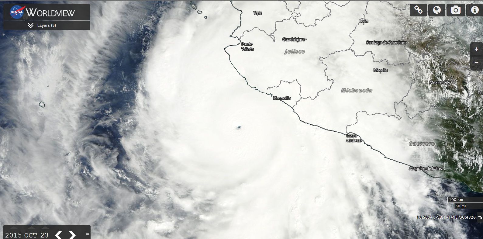
The powerful hurricane at peak intensity off the coast of Mexico is attached taken from NASA (MODIS Worldview) with place names overlaid. A feature of the storm is the tiny eye. The eye is unusually small given the size of the storm although it is visible.
The third image is the MODIS Worldview image showing the population centres along the coastline impacted by the storm. There are population centres along the coastline but it was fortunate that the eye came ashore missing the population centres north and south.
CREDITS
CIMSS (Wind data sets) acquired 24/10/2015.
Meso West – Weather station data from Weather Station CCXJI acquired 24/10/2015.
NASA (MODIS Worldview) images and overlays acquired 24/10/15.