
Following the passage of a cold front during Wednesday and Thursday 1 and 2 July that brought light snow to the high country of New South Wales and Victoria (2 to 10 cm at most), a cold air stream in its wake has resulted in some very cold nights being observed across south east Australia.
In particular, on the morning of the 3 July some cold locations and minimum temperatures include:-
Thredbo Top Station – Minus 7.7C at 3.30 am.
Goulburn – Minus 7.5C at 5 am.
Braidwood – Minus 6.7C at 7 am.
Falls Creek (NE Victoria) – Minus 6.4C at 6.30 am.
Rutherglen (NE Victoria) – Minus 4.6C at 7 am.
Cooma airport – Minus 3.1C at 5 am. However at 9 pm where conditions were calm, the temperature had plunged to minus 6C.
Albury Airport – Minus 1.8C at 7.30 am.
This has been ideal for snow making at the ski resorts following some light snow with the cold front.
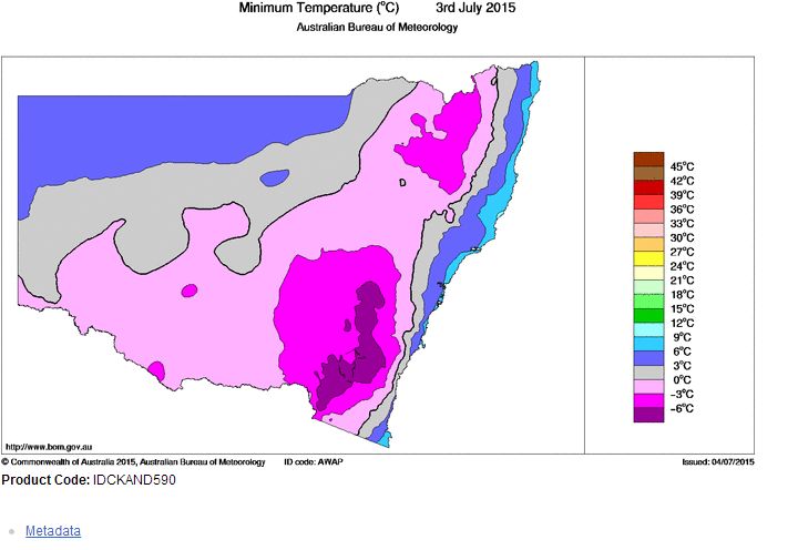
The attached plot generated at the Bureau of Meteorology – Water and the Land dated 4/7/2015 shows the minimum temperatures for the day across the state.
On the morning of the 4 July 2015, further cold weather occurred including:-
Falls Creek (NE Victoria) – Minus 5.5C at 3 am.
Canberra – Minus 5.5C at 6.30 am.
Braidwood – Minus 4.2C at 2 am.
Cooma – An interesting cold spell occurred here that commenced on the 3 July where at 6 pm 3/7/15, the recorded temperature had fallen to minus 0.2C. It fell to minus 6.2C at 9.30 pm under calm conditions. Overnight, a light but cold breeze developed that saw some warming occur where at sunrise 4/7/15, the temperature was at minus 2.8C. The temperature was minus 0.3C at 9.30 am. The temperature remained below 0 Celsius for 15.5 hours during the period which would have resulted in a significant frost.
Interestingly, the dewpoint at 9 pm was recorded at minus 8C.
Western Sydney
Western Sydney did not escape the cold where at Camden, the overnight minimum fell to minus 2.1C at 5.53 am and at Richmond, the minimum was 0C at 7 am (sunrise). At Blacktown, I saw light frost in open areas, early morning something which I have not seen for a few years. The minimum recorded temperature at Prospect was only 1.3C.
Daytime maximums were 14.6C at Richmond at 3.30 pm and 15.2C at Penrith at 3 pm which were below the average.
Tonight a forecast of minus 5 is being made for Canberra which under clear skies is likely to occur giving the city three very cold nights and mornings in a row to endure.
This morning Harley, I noticed when taking Kimberly to work that there was frost on my front lawn at Acacia Gardens. As I headed down the hill through Quakers Hill, the frost was gone. This was within the fog region. I have observed this a few times before. the normal case is that low lying areas are within the coldest zones locally. Condensation releases latent heat and therefore would have warmed up the localised area locally.
The two photos attached to the post is showing a morning frost in an open area at Bella Vista at sunrise Sunday 5 July. For the second morning in a row, frost was observed in Western Sydney which is indicative of a second cold night and something that I have not seen in many years.
The close up photo of the leaf shows the frost in greater detail. It is not heavy but significant enough to show how cold it was at 6.50 am Sunday morning.
Overnight minimums fell to 1.5C at Prospect. At Camden, a minimum of minus 1.1C was recorded at 7.18 am. At Richmond, a minimum of minus 1.2C was recorded at 7.05 am.
Again, very cold conditions were recorded across south east Australia especially on higher ground. The cold includes:-
Braidwood – A minimum of minus 4.7C at 7.30 am. The temperature fell to freezing level at 9 pm 4/7/15 when minus 0.4C was recorded and the temperature rose above freezing level after 9 am 5/7/15 when minus 0.7C was recorded. Evidence shows a period slightly more than 12 hours below freezing level.
At Cooma, a minimum of minus 4.6C was recorded.
At Canberra a minimum of minus 4.2C was recorded at 4.56 am.
Interestingly it reached 6C in Canberra at 3 pm which is indicative of a very cold day.
At Goulburn, a minimum of minus 4.9C was recorded at 7 am. During the period 3.30 am to 7.30 am, the temperature was at or below minus 4C which is a period of 4 hours.
This is showing a particularly cold spell during the period especially during the mornings and it is clear that frost has been common and most likely widespread.