A strong high pressure cell will now dominate much of eastern and south eastern Australia over the next four days. As a result, the days are expected to warm dramatically before a cooler change sweeps through south east Australia during Monday and Tuesday 14 and 15 September.
Northerly winds will become a feature and being warm and dry, the first outbreak of warm weather conditions will prevail across a large swathe of south east Australia.
It appears that the first 30C days for the new spring and summer season will occur within New South Wales with maximum temperatures being forecast to reach 30C at least for some inland north west towns. This should be limited in extent to places such as Bourke, Broken Hill and Wilcania.
Even across limited areas of coastal New South Wales, there are forecast maximum temperatures being made for 28C and 29C in places such as Wyong and Penrith.
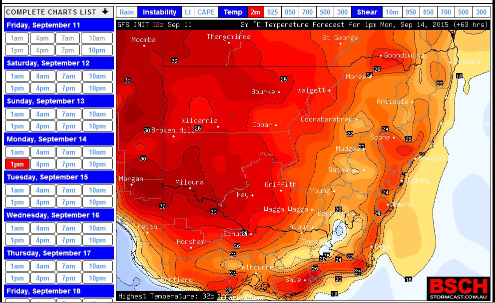
The attached temperature plots taken from the BSCH for Monday 14 September (1 pm on the 12Z Plot) shows potential for 30C temperature for far western New South Wales, western Queensland and the extreme north west of Victoria around Mildura.
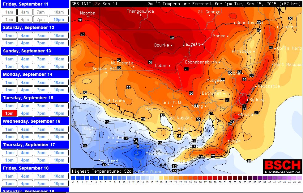
The attached temperature plot taken from the BSCH for Tuesday 15 September (1 pm on the 12Z plot) shows potential for 30C temperature for north western New South Wales and western Queensland. There will be a cool change moving across New South Wales throughout Tuesday but it will remain warm ahead of that change.
When viewing the plot more closely (The 12Z plot) even areas around Penrith in Western Sydney should experience maximum temperatures approaching 28C and maybe 29C. Tuesday appears to present the one and only chance where the first 30C maximum temperature for the season could potentially occur. If it did, it would likely be limited in extent.
Some maximum temperatures being made during the first warm outbreak includes:-
Adelaide - Saturday 27C and Sunday 29C.
Blacktown - Saturday 26C, Sunday 25C, Monday 26C and Tuesday 28C.
Cobar - Saturday 26C, Sunday 27C, Monday 28C and Tuesday 26C.
Bourke - Saturday 28C, Sunday 29C, Monday 31C and Tuesday 30C.
Broken Hill - Saturday 27C, Sunday 30C and Monday 31C.
Griffith - Saturday 23C, Sunday 26C and Monday 27C.
Melbourne - Sunday 24C.
Penrith - Saturday 27C, Sunday 26C, Monday 28C and Tuesday 28C.
Wagga Wagga - Sunday 24C and Monday 25C.
Wyong - Saturday 28C, Sunday 26C, Monday 28C and Tuesday 29C.
This provides some idea what is occurring. There are forecasts being made for some thunderstorm activity to occur with the cool change during Tuesday even through Sydney during the afternoon but any rainfall does not appear to be significant at this stage.
Over the past two days some reasonable warm weather has filtered into south east Australia. In particular on Sunday, 30C maximum temperatures occurred within New South Wales although limited to the far west of the state. The highest temperatures for Sunday were 31C at Fowlers Gap and Tibooburra and 30C at Whitecliffs.
On Monday, more 30C maximum temperatures occurred within New South Wales although limited to the far western areas of the state. These include 32C at Mildura and Wilcania, 31C at Tibooburra and 30C at Ivanhoe, Bourke and Broken Hill. This shows the change of seasons starting to occur and also shows that this is a strong burst of heat for early to mid September.
A cool change is now crossing through Victoria and New South Wales. On Tuesday, the warmth contracts east and there is a forecast of 29C to 30C maximum temperatures being made for Western Sydney within the area of Parramatta to Penrith, Liverpool and Richmond. It will be interesting to see whether the maximum highs are reached given the approach of the cool change later in the day.
Tuesday saw the last day of the four day warm spell across south east Australia. Today, a cooler wind change moved through much of southern and central New South Wales. Maximum temperatures ahead of the change were again above average.
In addition, Tuesday saw the third day in a row where 30C maximum temperatures were recorded somewhere within New South Wales. The highest maximum temperatures recorded were 31C at Bourke, Coonamble, Lightning Ridge and Walgett.
Here in Sydney where a very warm dry north west wind prevailed with mostly sunny conditions, the first 30C temperature for the season was also recorded. This occurred at Sydney Airport where 30.5C was recorded. Penrith came close on 29.9C, Sydney Observatory Hill at 29.8C, Holsworthy on 29.7C and Richmond on 29.6C were the other significant maximums for the day. Hence, the 30C mark was almost reached across a large swathe of Sydney.
Generally warm conditions occurred right along the New South Wales coast except for the South Coast region.
Cooler conditions will now prevail over south east Australia for several days as the wind change takes hold.