Video showing the wedge tornado as it maxed out rapidly! Although I have zoomed a little the relatively wide angle still shows just how massive this tornado was and we were at this point a few kilometres from the tornado!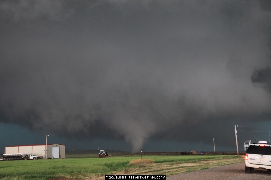
The El Reno tornado developed on a day exhibiting potent conditions - an environment with extreme CAPE and an explosive atmosphere. The tornado emerged from the mass of cloud and instantly began to produce vorticies! We were only about 1km from the tornado.
Progressive videos will be added over the coming days to show different stages of the tornado and associated event! This is now the most incredible and dynamic storm I have ever seen!
Unfortunately, this event took the lives of at least 4 storm chasers chasing the tornado, injured several others and also damaged or toppled vehicles of at least two other chaser teams who survived through shear luck their vehicle was not taken up into the tornado. This is the first time such a tragedy is know to have occurred in storm chasing history.
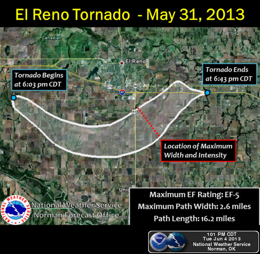
NWS Norman have now confirmed this to be the widest tornado in history.
This video shows well how the tornado seemed to be moving parallel to these chasers but was in fact heading towards them rapidly. They realise this like others quickly retreat.
This tornado ended up being 2.6miles wide – the widest in US history. This is certainly a historic storm. It claimed victims which included storm chasers. The track was unusual with a pivot or slingshot effect moving the tornado rapidly NE. The sudden expansion from about 1 mile wide to 2,6miles wide in 30 seconds – yes 30 seconds! made this tornado lethal for anyone who were very close. 2.6 miles wide is 4.2km in width. If you are close, you cannot even tell you are next to one apart from the inflow jets. The inflow jets recorded made it virtually impossible to drive. Scary for those who experienced such.
Hi Jeff, I watched the video here. Not sure if I saw Michael Thomas in the video:) Nevertheless, it was basically the path we followed. I am wandering though that the tornado was partially south of the road so wandering if they remained on W Reno Avenue or not. I will post more video tonight of us under the massive base!
I watched the video but I must of missed seeing me :) We were very close to where this was filmed. I think it is worth mentioning that the shed here – http://www.extremestorms.com.au/wp-content/uploads/2013/06/el_reno_tornado01.jpg was destroyed. At that time the tornado was moving SE.
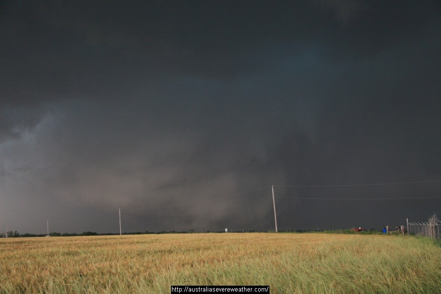
This event goes to show that not all tornadoes can be approached safely! I think with so many getting up extremely close to single vortex tornadoes there has probably developed a bit of complacency but this event should hopefully correct that. EF 5 multi-vortex wedge tornadoes of this magnitude should be given a much wider berth then 100-200 yards. This was a super supercell! It needs a whole new category!
Yes, I agree Jeff. A super supercell indeed. Quite fascinating seeing this storm develop. Everything really came together for a monster storm. My understanding of the situation was that the surface winds needed to back SE prior to initiation to really ramp up the tornado potential. This is exactly what happened. Prior to initiation, surface winds were ~ S'ly in the early afternoon. When the first storms went up, the surface winds had backed to the SE. Also notable was the increase in wind speed as the storms continued to develop. Just before the tornado formed, the base had lowered substantially and there was strong storm-scale rotation. Also important I suspect was the strong cap further south which allowed convection to remain constrained to the dryline/cold front intersection and east thereof. Amazing to see but tragic at the same time.
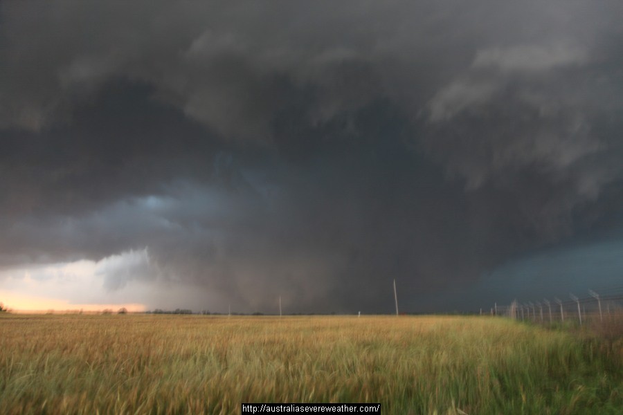
Jeff and Michael, this mega supercell displayed behaviour I personally have never witnessed previously. Typically what I look for are backing winds or already backed winds, lowering bases, capping, rotation etc. This process occurred at an accelerated rate like I have never seen before. The base LCL levels lowered considerably and the storm organised dramatically despite the high precipitation nature. The rotation developed and wall cloud organised quickly but became rain wrapped. The way the rotating base emerged out of the cloud was unique. This storm did not muck around at any point!
More video of the EF-5 widest tornado in history series – this time of our escape east! El Reno Tornado chasing the chaser and sheriff! Check our page here.
A quote from stormgasm is worth reading for this event!
The supercell developed in an extremely volatile environment with local environment effective-layer EHI (Energy Helicity Index) values between 18-23 (calculations performed by Juston Drake and Simon Brewer), which is ridiculous considering many past violent tornadoes have occurred in environments approaching the 10 effective-layer EHI value. EHI values are derived by a combination of environmental CAPE (energy) analysis and Helicity analysis (shear). The tornado and parent supercell were able to fully take advantage of the extreme atmosphere in Central Oklahoma and literally “blow up” south of El Reno becoming a figurative black hole causing everyone including storm chasers to run for their lives.