A strong high pressure cell located within the Tasman Sea is positioned in such a manner that will allow hot dry north westerly winds to prevail for a period of 4 to 5 days over southern and eastern Australia.
This should result in maximum temperatures for early October exceeding 30C for 4 to 5 days depending on location across a large swathe of southern Australia. The warm spell is expected to end during Tuesday and Wednesday as cooler air moves through.
The warm spell has commenced Friday with many inland western centres recording maximum temperatures reaching 30C to 33C with 33C being recorded at Lightning Ridge and Walget.
A big feature of this weather event is that it is widespread and is expected to reach coastal locations although places right on the coast such as Narooma and Ulludulla will not feel as much heat due to sea breezes prevailing.
Maximum temperatures of 30C are common in October including across Sydney however it is rare to have a period of 4 to 5 days in a row of such temperatures prevailing. This is expected to occur.
Another feature of this period is that temperatures are forecast to reach 38C and even 39C across limited regions of far south west New South Wales and far north west Victoria at places such as Mildura (Monday and Tuesday) and Balranald (Monday and Tuesday).
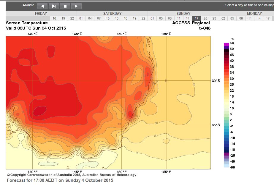
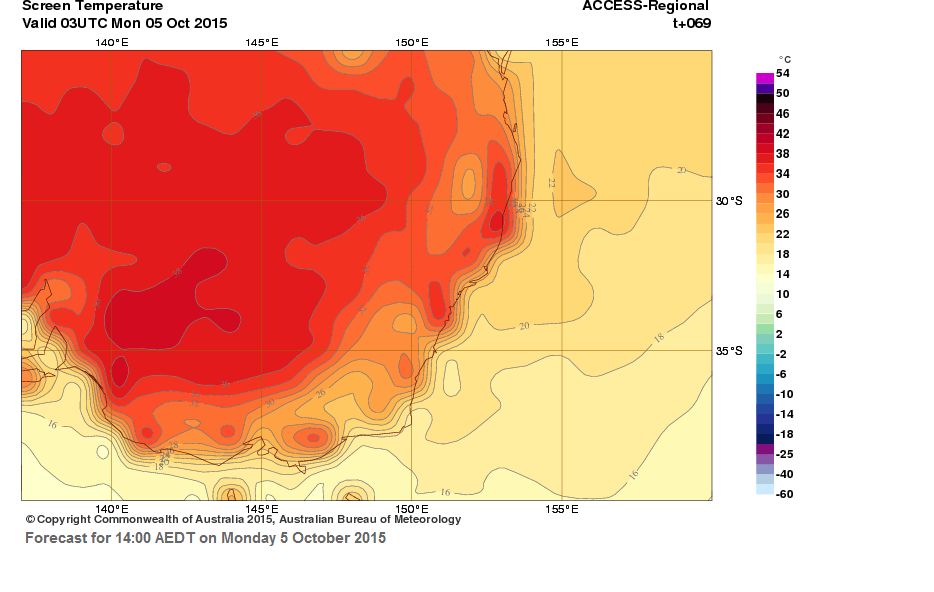
The Bureau of Meteorology (ACCESS Model) surface temperature for 2 pm for Sunday and Monday is showing the widespread nature of the heat expected to occur. The hottest regions on both days is likely to be far south west New South Wales (For southern Australia) and it is identified that western Sydney will heat up as well. A similar situation will prevail for Tuesday and at least for Wednesday although a cool change will be passing through that will end the current run of 30C temperatures.
Some forecast temperatures being made which provides an overview of what is occurring are:
Albury - Sat (29C), Sun (29C), Mon (31C), Tue (32C) and Wed (26C).
Balranald - Sat (35C), Sun (37), Mon (38C), Tue (38C) and Wed (26C).
Batemans Bay - Sat (32C), Sun (35C), Mon (32C), Tue (31C) and Wed (26C).
Blacktown - Sat (34C), Sun (35C), Mon (35C), Tue (34C) and Wed (34C).
Buladelah - Sat (32C), Sun (36C), Mon (37C), Tue (37C) and Wed (36C).
Dubbo - Sat (31C), Sun (33C), Mon (34C), Tue (34C) and Wed (34C).
Mildura - Sat (36C), Sun (37C), Mon (39C), Tue (38C) and Wed (26C).
Richmond - Sat (35C), Sun (36C), Mon (35C), Tue (36C) and Wed (35C).
Scone - Sat (31C), Sun (33C), Mon (34C), Tue (35C) and Wed (34C).
Sydney - Sat (28C), Sun (35C), Mon (30C), Tue (30C) and Wed (30C).
Wagga Wagga - Sat (30C), Sun (30C), Mon (32C), Tue (33C) and Wed (27C).
Based on this sample, the heat is expected to be widespread. The above places are chosen to show its widespread nature and to show that forecasts are being made for 38C at limited locations well away from the coast. Only the very coastal strip and elevated areas will not experience such warmth.
This will also impact northern Victoria but less so for southern areas of that state.
CREDITS
Bureau of Meteorology (ACCESS Model) acquired 2 October 2015.
Over the past two days, some warm temperatures have been felt across south east Australia as follows:-
Saturday 3 October 2015 (Some samples)
Pooncarrie 36C.
Fowlers Gap 35.7C.
Tibooburra 35.6C.
Penrith 34.8C.
Mildura 34.7C.
Narooma and Ulludulla 34C.
Sydney Olympic Park 33.7C.
Broken Hill and Richmond 33.6C.
Prospect 33.2C.
Batemans Bay 32C.
The warmth was widespread and reached the coast.
On Sunday 4 October 2015, the warmth was widespread as follows (Readings taken at 3 pm):-
Mildura 37.3C.
Ivanhoe and Wilcania 37C.
Moruya 36.6C (This was taken at 2.30 pm. A shallow but weak south east change moving along the south coast impacted temperatures in this region. At 4pm, the maximum temperature had plummeted to 21.8C as SSE winds passed through. That change has only impacted the south east coastal locations.
Broken Hill and Trangie 36C.
Deniliquin 35.8C.
Walgett 35C.
Dubbo 34C.
West Wyalong 32.5C.
For two days now, the warmth has been widespread and maximum temperatures have been reaching what has been forecast or close to the forecast maximums. Even in Sydney, much of the city has enjoyed two days in a row of 30C temperatures especially for those areas away from the effects of the sea breezes such as Parramatta, Blacktown, Penrith and Camden.
During Monday 5 October, some high maximum temperatures occurred across south east Australia. In particular, the following is noted:-
1 – An official maximum temperature of 40.1C has occurred at Nullabor (South west South Australia at 3.39 pm).
2 – There are places that reached 38C.
3 – The heat was widespread. across Victoria, South Australia and New South Wales.
4 – A temperature of 37.8C occurred at Sydney Olympic Park with is exactly 100F.
5 – Incredible as it seems, maximum temperatures on the south coast of New South Wales varied widely depending on location and impact of the sea breeze. For example, at Moruya, the maximum temperature reached 23.2C while at Nowra 35.9C occurred.
The event clearly marks 3 days in a row where it has reached 30C across much of Sydney.
The heat is coming ahead of a south west wind change which will begin to cross Victoria and New South Wales during Tuesday. Anywhere ahead of that wind change, it will be warm again for Tuesday.
Some maximum temperatures for Monday 5 October include:-
SOUTH AUSTRALIA
Nullabor 40.1C.
Ceduna 38.8C.
Port Augusta 37.8C.
Whyalla 37.5C.
VICTORIA
Walpeup 37.4C
Swan Hill 37.2C.
Mildura 37.1C.
Kyabram 34.8C.
Melbourne 33.3C.
Ballarat 29.7C.
NEW SOUTH WALES
Wilcannia 38C.
Sydney Olympic Park 37.8C.
Ivanhoe 37.3C.
Penrith 37.1C.
Deniliquin 36.3C.
Camden 36C.
Hay 36.2C.
Observatory Hill (Sydney) 35.6C.
Griffith 34.7C.
Sydney Harbour off Bradleys Head 27.5C.
This shows to some degree, the extent of the heat during Monday 5 October 2015.
The fourth and final day of this early October hot spell has come to a conclusion. In addition, a south to south west wind change is now crossing through Victoria and south western New South Wales. Many centres across the south east have now endured 4 consecutive days of 30C heat which is unusual for October due to it’s extent and longevity.
For Tuesday 6 October, much of Victoria endured an uncomfortable warm night before the final days heat or south west change whichever came first. In particular, a weather station at Cape Otway (Southern Victoria) recorded a minimum overnight temperature of 24.9C. At 8.30 am, the temperature was already 27.3C which was the maximum for the day. By 11 am, the temperature had fallen to 17.3C as the change took hold.
In Melbourne which has just experienced two consecutive days of 34C or higher, the maximum daytime temperature was 35C under a hot dry north west wind at 2.30 pm. By 4 pm, the temperature had fallen to 21.3C as southerly winds started to prevail. It is rare for Melbourne to have 2 days in a row of 34C during October.
Across Victoria at least ahead of that wind change Mildura reached 37.2C, Shepparton reached 35.6C and even Albury had 33.8C. These are high maximums for early October.
NEW SOUTH WALES
The maximum temperature for the day appears to be at Penrith where 38C was recorded at 2.30 pm and again at 3 pm. This makes it 2 days in a row of 37C or higher at Penrith.
Following that, a number of weather stations recorded 37C or slightly higher being:-
Ivanhoe 37.6C.
Wilcania and Homebush Bay (Sydney) 37.5C.
Hay 37.2C.
Moruya 37.1C (This is impressive considering the maximum temperature for October 5 was just over 23C).
White Cliffs and Walgett 37C.
Even at places such as Ulludulla, the maximum temperature reached 35.7C and Narooma reached 36C.
There are numerous centres across the inland and coast including Sydney where maximum 30C temperatures or more featured.
The cooler southerly change will continue to pass through New South Wales overnight and the heat will contract northwards and for Wednesday, will be limited in extent to more northern areas. It will now be a while before such temperatures return to the levels seen over recent days across the south east.