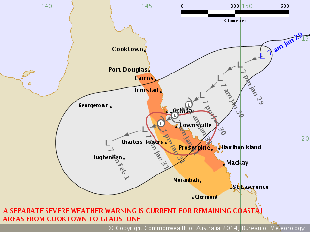
A Tropical Cyclone Watch has been issued by the Bureau of Meteorology for the Townsville region and nearby locations. Based on the forecast map, the most intense part of this developing tropical cyclone will pass north of Townsville as a Category 1. Very heavy rainfall, strong winds and flooding is anticipated from this event. A 1 metre storm surge is likely if this system develops.
Matthew Piper is in Townsville now and will get experience the tropical cyclone!
Matthew Piper is in Townsville now and will get experience the tropical cyclone!
Hot and muggy here in Townsville at the moment with increasing high level cloud from the north as the outflow of the developing cyclone moves over. Not much in the way of wind yet with just a moderate breeze where I live near Bushland Beach. Latest track map would have the worst part of the eye wall pass directly over me, but luckily it is only expected to be a cat 1 at this stage.
Hot and muggy here in Townsville at the moment with increasing high level cloud from the north as the outflow of the developing cyclone moves over. Not much in the way of wind yet with just a moderate breeze where I live near Bushland Beach. Latest track map would have the worst part of the eye wall pass directly over me, but luckily it is only expected to be a cat 1 at this stage.
So you live to the north of Townsville itself! How did you manage a direct path! Stay safe!
So you live to the north of Townsville itself! How did you manage a direct path! Stay safe!
Have just received a message on my phone from the council urging residents who live in the red storm surge zones to prepare their homes for inundation tomorrow (Red zone is flooded in a storm surge up to 1m above highest astronomical tide). We are luckily not in any of the storm surge zones, but heavy rain could still cause some local flooding issues near me.
Have just received a message on my phone from the council urging residents who live in the red storm surge zones to prepare their homes for inundation tomorrow (Red zone is flooded in a storm surge up to 1m above highest astronomical tide). We are luckily not in any of the storm surge zones, but heavy rain could still cause some local flooding issues near me.
Matthew Piper any more news – any pictures? How are you fairing as this approaches?
Matthew Piper any more news – any pictures? How are you fairing as this approaches?
Jimmy DeguaraTorrential rain and very strong winds at the moment. Unsure of rainfall amount, but would have to be at least 50mm I would say during the last half an hour. Everything alright though, but the worst is yet to come this evening as the cyclone passes either over or very near us. Could possibly reach cat 2 strength as it is developing fast.
Jimmy DeguaraTorrential rain and very strong winds at the moment. Unsure of rainfall amount, but would have to be at least 50mm I would say during the last half an hour. Everything alright though, but the worst is yet to come this evening as the cyclone passes either over or very near us. Could possibly reach cat 2 strength as it is developing fast.
The rainfall is being caused by a strong feeder band on the western side of the cyclone. It is hardly moving and is definitely going to cause some local flooding issues if it keeps up much longer.
The rainfall is being caused by a strong feeder band on the western side of the cyclone. It is hardly moving and is definitely going to cause some local flooding issues if it keeps up much longer.