Tropical Cyclone Nathan is one unusual cyclone. After crossing the Queensland coast Friday morning and breaking apart into a tropical depression over Cape York Peninsular, the storm continued to track west over land and entered the Gulf of Carpentaria during Saturday. The storm redeveloped and intensified again into a weak tropical cyclone.
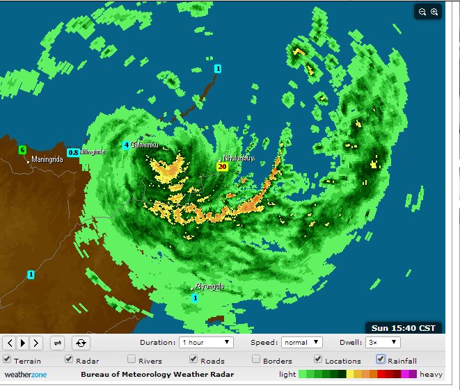
This tropical cyclone has now had three lives. The storm crossed the Northern Territory Coast near Nhulunbuy and has brought wind gusts to 95 km/h.
The local weather station recorded gales of between 93 km/h and 95 km/h from 9.30 am to 11.30 am 22/3/2015.
The storm is now partially over land and partially over water traversing west along the Northern territory coast. It is not a strong tropical cyclone but it is bringing with it thunderstorm activity.
The weather station at Nhulunbuy recorded a low pressure of 995.1 hectopascals at 10 am. Rainfall has not been heavy at this weather station being 20.2 mm from 9 am to the present time.
The weakened storm is now impacting Elcho Island where its local weather station is recording wind gusts to 80 km/h.
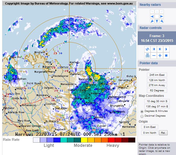
The attached radar image shows the shape of this storm as it passes west along the Northern Territory coastline.
Tropical Cyclone Nathan is certainly an unusual storm system. During 23/3/2015, this storm has traversed the northern coastline of the Arnhem Land (Northern Territory) barely maintaining an eye.
While there have been media reports suggesting winds reaching 140 or 150 km/h this storm is passing close enough to a number of weather stations which are providing accurate readings of what is occurring.
Elcho Island
This storm passed close enough to the weather station at Ngayawili (Elcho Island). A peak wind gust of 107 km/h was recorded at 7 pm 22/3/2015. Peak wind gusts exceeded 100 km/h from 6 pm (104 km/h) to 7.30 pm (100 km/h). Winds eased after this time.
A low pressure reading of 993.8 hectopascals was recorded at 6 pm.
Unknown, this station stopped recording after 10.30 pm but wind gusts were well under 100 km/h (74 km/h) last reading. It is unknown whether the weather station is damaged or not.
Milingimbi
The weather station recorded a peak wind gust of 104 km/h at 5.46 am from the SSE (Highest gust).
Rainfall – 98.4 mm to 9 am (23/3/2015) and another 61.6 mm to 5 pm (23/3/2015).
Maningrida
This weather station recorded a peak wind gust of 83 km/h at 10 am (23/3/2015) and 40 mm of rain to 5 pm.
Gove
Heavy ran of 161 mm is recorded to 9 am and another 64.8 mm to 5 pm (23/3/2015).
Heavy rain is a feature south of the eye but Arnhem Land is remote with few recording stations available.
The storm is now struggling to hold together as it is becoming embedded with monsoon cloud. As shown in the radar image, it still has an eye just north of Maningrida but it is barely holding together as a tropical cyclone. It should make landfall where it should end its life span.
The tropical cyclone crossed the coast of the Northern Territory and decayed. However during its decay, it unleashed some significant rainfall across remote areas of the Northern Territory top end. Heavy rainfalls for the period 24/3/2015 include:-
Milingimbi – 140 mm.
Yirrkala Tropical Gardens – 135 mm (Location is at Nhulunbuy).
Gove – 134 mm.
Nhulunbuy Trans – 121 mm.
In particular and when combined with the previous reading, the town of Gove received some 295 mm from this event.
It is likely that other heavy falls of similar nature occurred in this region but due to the remote location and lack of recording stations, such records will never be known.
This storm tracked south west towards Katherine during its final decay where some substantial falls were also recorded for the 24 hours to 25/3/2015 including:-
Fanny Creek – 261 mm.
Snowden Creek – 208 mm.
Birdie Creek – 164 mm.
Upper Katherine River – 163 mm.
Upper Waterhouse River – 143 mm.
Mount Staw – 136 mm.
Yeuralba Ridge – 128 mm.
This region is north east of Katherine but on the southern flanks of Kakadu National Park. The storm lost its intensity in this region during its final decay.