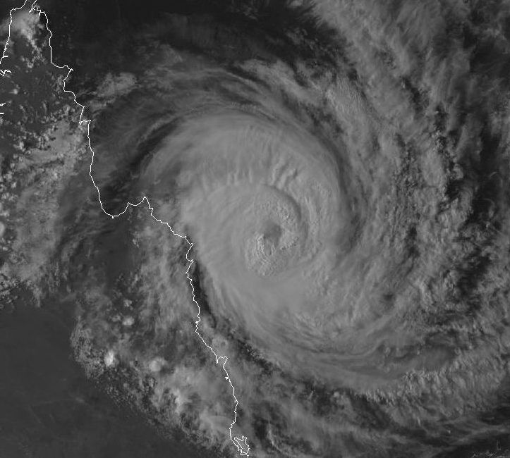
As seen in the satellite photo late 19 March 2015, Tropical Cyclone Nathan is now a well formed storm, highly compact and clearly edging closer to the Queensland Coast. Throughout Thursday, the first outer rain bands have reached the coast although rainfall totals are not high but that is expected to change overnight.
Models suggest the storm impacting an area near Cape Flattery and Bureau of Meteorology Models suggest landfall north of Cairns but near Cape Melville and or Cape Flattery during Friday.
Media reports are suggesting peak wind gusts to 195 km/h near its core with sustained winds of 140 km/h although such winds are yet to be recorded because the storm has not passed directly over a weather station.
The eye of the storm has passed some 60 km north of the Bougainville Reef Weather Station which has been recording wind gusts exceeding 100 km/h since 10 am 19/3/2015 with the highest wind gust to 111 km/h at 4 pm from the east south east. Since 2.43 pm, peak wind gusts here have reached from 104 km/h to 106 km/h. The storm is now NW of this weather station and moving west. At the present time, this has been the closest weather station to the core and these are the highest wind gusts recorded. This provides some idea as to what is occurring closer to the storm core.
It will be interesting to see what occurs over coming hours given that the outer edges of the storm has now reached the North Queensland Coast.
Given that is becoming a significant weather event for far North Queensland, I attach an image of the storm shown in Infrared. It is clear that this is a well developed storm but it is not large in area.
At approximately 3 am 20/3/2015 (Queensland time), the eye of the storm commenced landfall barely a few kilometres north of Cape Flattery (I estimated 2 to 5 km north of Cape Flattery). The Cape Flattery weather station is well within the eye wall and well positioned to obtain accurate wind speeds of the storm but assuming it is not damaged by the storm.
When analysing the data from this station, a maximum wind gust of 150 km/h was recorded at 2 am and a maximum peak wind gust of 152 km/h was recorded at 1.49 am.
There has been no recording of wind speeds in the 1 hour from 2 am to 3 am Queensland time (4 am Eastern Daylight Savings Time). I am unsure if the wind vane is still functioning or not but the rain gauge is still functioning and showing 67 mm of rain to 4 am (3 am Queensland time).
Whatever happens, the Cape Flattery Weather Station is the crucial weather station for this storm.
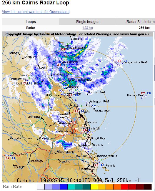
I attach the radar image at 4 am (EDST), 3 am Queensland time showing the eye wall commencing landfall. This is the better image given its location. The eye wall is just west of Lizard Island and barely north of Cape Flattery.
Note:- I have just looked again at Cape Flattery weather station again. The wind vane is still functioning and currently shows a maximum wind gust of 161 km/h at 2.30 am. Appears it was slow to update.
Hi Harley,
“Deep Breath”!
Nathan was looking like a well developed category 2 cyclone that was transitioning into a category 3 system as it made landfall, as you said Harley, barely a few kilometers north of Cape Flattery. I estimate the eye itself with calm winds was only about 10-15km north looking at the radar from Cairns. Olywn’s pressure dropped to 970 and it had gusts to 180km/h, Nathans pressure droppped to 990 with gust to 160km/h, that would obviously make it weaker than Nathan and therefore weaker than a category 3 system of which Olwyn was.
As with TC Olwyn, Nathan has grazed a weather station giving us accurate details of the intensity of the cyclone but unlike Olwyn which had reached category 3 when it passed by Learmonth, Nathan looks to have not quite made Category 3 intensity when it grazed cape flattery.
Given these observations which we have now set in stone from weather stations that were in the path of both storms, what the heck is the BoM doing rating it a category 4??? I’m totally lost trying top understand there logic as it is obviously not based on any kind of verifiable observation which we have from Cape Flattery. Do they really think that the intensity difference could be Cat2 to Cat 4 over a few kilometers? That is absurd and i’m no longer going to listen to any of their forecasts as they are obviously on some kind of agenda in the Queensland BoM to over inflate everything.
Regards Jeff.
The crucial readings from Cape Flattery are:-
1 – Highest wind gust of 161 km/h at 2.30 am.
2 – Lowest air pressure of 989.8 hectopascals at 2 am and 989.9 hectopascals at 2.30 am (Coinciding with the highest wind gusts recorded).
3 – Highest sustained wind speed was 120 km/h at 2.30 am.
As the storm made landfall, this storm weakened fast. At Cape Flattery, peak wind gusts eased back to 146 km/h at 2.43 am and 2.50 am and 128 km/h at 3 am. The last 100 km/h wind gust occurred at 3.30 am and winds eased thereafter.
I have seen various media reports suggesting winds reaching from 230 to 260 km/h however this is not verified. Jeff has alluded to the issue in his post above.
The storm did pass over Lizard Island and I have become aware that AIMS operate a recording station on this island. I have managed to locate it but it appears to be a Marine Observation device only. I could only find data for water temperature and no data for wind, air pressure and rainfall. Any assistance is helpful as I am not aware of any other recording device in the vicinity of this region or island.
Highest rainfall recorded for the 24 hours to 9 am 20/3/2015 were:-
Battle Camp – 166 mm (Inland south west of Cape Flattery).
Cape Flattery – 113 mm.
Cooktown region
Flaggy TM – 93 MM.
Beesbike – 84 mm.
Cooktown – 82 mm.
This system broke apart rapidly as it came onshore and large rainfall totals are sparse. It is now a rain depression over land.