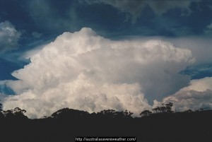
 On this day in 2000, I was in northern NSW chasing the region with a very favourable setup with surface lifted index values of -10. Of course, it was in the early days and little did I know at the time that winds can carry that very potent region further east! Well it mostly occurred on the Northern Tablelands beginning with Dorrigo (billiard sized hailstones at 11am!) and then Grafton region later. There were several storms in this region and northern NSW during this event and the day after! This storm was observed on the road east of Inverell and just prior to descending the escarpment. Quite impressive convection. An impressive cumulonimbus cell developed near Grafton and Ballina region with cloud to clear air lightning observed from both storms!
4 thought on “Supercell Mushroom Cloud – 4th November 2000”
Leave a Reply
You must be logged in to post a comment.
Can’t believe it was 12 years ago today! Supercell mushroom structure near Grafton.
Yes, and difficult to get off the NT and into the NRs if necessary. Is your previous photo the same storm? If so, how long before?
Michael, yes the photo I would suggest was probably within 10 or so minutes earlier. I also missed out on getting a nice shot looking down off the escarpment afterwards if the hail shaft. My rule now is stop and take the shot as you go!
Pretty amazing how much the structure improved in a short time! Yes you have to get the shots while you can especially on unfamiliar roads