
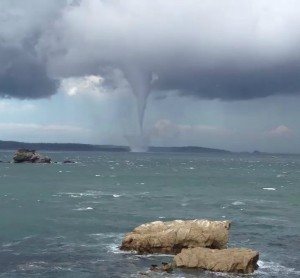
A tornado was observed and wodely filmed by on lookers on the South Coast region of Batehaven. This represents one of the most impressive tornadoes spawned by a supercell off the South Coast. Extensive video from several angles have provided ample visual documentation of this particular tornado of the storms's behavour and structure! The tornado was in a stove pipe stage for an extensive period of its life cycle. It seems to begin entering a rope out stage after more than 5 minutes.
23 thought on “Storms & Waterspout Tornado NSW South Coast 18 November 2012”
Leave a Reply
You must be logged in to post a comment.
Wow wow looks so much like the Sydney to Hobart Yatch Race spout from 2001! This storm season has really made up for the poor start!
Wow wow looks so much like the Sydney to Hobart Yatch Race
Wow thanks for that footage Kane! The dynamics do indicate tornado as Jeff suggested. The tornado was going to rope out in the final stages.Interesting to see the type of boundary that would have assisted in this development!
What a beast of a Tornado! I really wish I chased down there now but had things on. You really have to either live there and get lucky or chase every single storm system with an iota of potential.
Not only the tornado though, the cell itself is a beautiful textbook classic supercell, albiet probably low topped, but still a genuine classic supercell with what looks like a strong stovepipe tornado. Flipping awesome! I would give every storm chase ever to be even on the beach there, and even better if I was out in a boat!
I guess it was an atmospheric accident. You mentioned a dryline coming through Sydney that day. Perhaps the dryline came through down south as well and interacted with the NE flow and I wonder if there was boundary as well – in one of the videos you could see jets racing across the water. It may have created a triple point!
You never know Jimmy. This is easily the best tornado filmed in Australia for a few years and it goes to show that that area has a consistent history of these events. I will take these types of setups more seriously next time.
Jeff, it would have been awesome. But to tell you the truth, the area was not in a serious forecast risk until that morning or perhaps the day before. Imagine taking the risk of leaving 2000 to 3000 CAPE to a marginal situation? I do believe this was a very difficult event to predict.
Taken this afternoon near Batehaven.
I love this particular video as it shows more of the supercell structure and rotation!
More videos posted in here! This tornado is pretty serious! It could have produced F2 damage had it hit land!
Nice to see originality!
This one shows the morphology of the tornado including the beginning of the rope out stage!
I am aware my brother who lives in Batemans Bay watched this event. It appears from what my brother said to me, he and others being in the fire brigade were monitoring this event ready to respond to any incidents had it hit land. I am familiar with Batehaven Beach. Fortunately it occurred directly east of Batemans Bay out in the bay. Had it made landfall NE of town, it would have gone through forest and part of Murramarang National Park where few live. Quite spectacular. In all my years visiting my parents here, I never expected to see a weather event like that to occur.
Sorry about the added videos but each show one more feature not easily observed on another – this one is zoomed in and shows how the RFD pushes down behind the tornado!
That is true Jimmy, but Australia does get more tornadoes from low topped supercells in high shear/low cape environments. This tornado sounds similar to the merimbula tornado of many years ago and it would be interesting to compare events and setups. How also would this even compare to the tornado near cooma/nimmatabel a couple of years ago.
Just out of interest Jeff, where were you thinking of targeting had you the opportunity to chase on the Sunday?
What an insane event! I do recall another major waterspout/ tornado like this off Batemans Bay earlier this year, though it was further out to sea.But as was mentioned, there's no doubt this area is a little hot spot for these type of events. I was chasing on this particular day, but unfrtunately targeted the Ulladulla area, and then Baweley Point which is located roughly half an hour north of Batemans Bay. I did however witness the very interesting line that developed off Ulladulla and managed to keep backbuilding all the way up to coastal waters off Gosford and beyond. Some of the updrafts were spectacular, and once nightfall had arrived flashes every to two seconds were visable though very few ground strikes,,,
Michael, post the pictures of those storms on this thread thanks!
Jimmy, I would have chased from Bermagui to Bega and Merimbula so the far south coast. That way I would have options of heading up to the tablelands if things up there were more interesting. I doubt I would’ve been in position to see this tornado if I did chase down there as the region immediately around Batemans Bay has too many trees for my liking.